 Arctic SDI catalogue
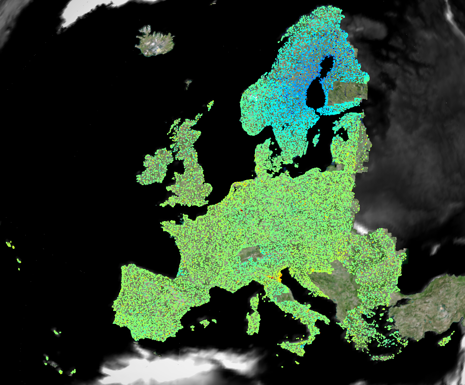
European Ground Motion Service: Basic 2019-2023 (vector), Europe, yearly, Oct. 2024
The European Ground Motion Service (EGMS) is a component of the Copernicus Land Monitoring Service. EGMS provides consistent, regular, standardised, harmonised and reliable information regarding natural and anthropogenic ground motion phenomena over the Copernicus Participating States and across national borders, with millimetre accuracy. This set of metadata describes the first product level of EGMS: Basic.
The EGMS Basic - provides InSAR displacement data provided in the satellite Line-of-Sight (LOS), with annotated geo-localisation and quality measures per measurement point. This product is generated from the interferometric analysis of Sentinel-1 radar images at full resolution. It contains line of sight velocity maps in ascending and descending orbits with annotated geolocalisation and quality parameters per measurement point. The Basic product is referred to a local reference point; therefore, ground motion measurements are meaningful only within a small subset of the full product. It is not possible to compare deformation from adjacent areas belonging to different processing units of the same level.
EGMS Basic is visualised as a vector map of measurement points colour-coded by average line-of-sight velocity and distributed to users in comma-separated values format. Each point is associated with a time series of displacement, i.e. a plot with values of displacement per acquisition of the satellite. The product is generated for both ascending and descending orbits.
The processing of the dataset has taken place in the period from March 2024 to October 2024.
Simple
- Date ( Creation )
- 2024-03-15
- Date ( Publication )
- 2024-10-29
- Edition
- 01.00
- Identifier
- copernicus_v_3035_20_m_egms-basic_p_2019-2023_v01_r00
- Unique resource identifier
- 10.2909/7eb207d6-0a62-4280-b1ca-f4ad1d9f91c3
Point of contact
- Maintenance and update frequency
- Annually
- GEMET - INSPIRE themes, version 1.0 ( Theme )
-
- Natural risk zones
- Keywords
-
- Continents, countries, sea regions of the world. ( Place )
-
- Norway
- Iceland
- EU27 (from 2020)
- United Kingdom
- Keywords
-
- GEMET ( Theme )
-
- risk reduction
- geo-referenced data
- infrastructure
- subsidence
- earth observation
- geological process
- urban area
- landslide
- built environment
- Spatial scope ( Theme )
- Temporal resolution ( Temporal )
-
- Weekly
- EEA Management Plan ( Theme )
-
- 2024 6.5.32
- Access constraints
- Other restrictions
- Other constraints
- no limitations to public access
- Use constraints
- Other restrictions
- Other constraints
-
The Copernicus component is governed by Regulation (EU) No 2021/696 of the European Parliament and of the Council of 28 April 2021 establishing the Union Space Programme and the European Union Agency for the Space Programme and repealing Regulations (EU) No 912/2010, (EU) No 1285/2013 and (EU) No 377/2014 and Decision No 541/2014/EU. Within the Copernicus component, a portfolio of land monitoring activities has been delegated by the European Union to the European Environment Agency (EEA) and the DG Joint Research Centre of the European Commission.
The Copernicus land monitoring products and services are made available on a principle of full, open and free access, as established by the Commission Delegated Regulation (EU) No 1159/2013 of 12 July 2013.
Free, full and open access to the products and services of the Copernicus Land Monitoring Service is made on the conditions that:
1. When distributing or communicating Copernicus Land Monitoring Service products and services (data, software scripts, web services, user and methodological documentation and similar) to the public, users shall inform the public of the source of these products and services.
2. Where the Copernicus Land Monitoring Service products and services have been adapted or modified by the user, the user shall clearly state this.
3. Users shall make sure not to convey the impression to the public that the user's activities are officially endorsed by the European Union.
- Aggregate Datasetindentifier
- 8889e0a7-a6df-47a8-b4e7-a9cb32cbbf6b
- Association Type
- Cross reference
- Spatial representation type
- vector Vector
- Distance
- 20 m
- Metadata language
- en
- Character set
- utf8 UTF8
- Topic category
-
- Geoscientific information
))
- Begin date
- 2019-01-01
- End date
- 2023-12-31
))
))
- Unique resource identifier
- EPSG:3035
- Unique resource identifier
- EPSG:32738
- Unique resource identifier
- EPSG:32740
- Unique resource identifier
- EPSG:32620
- Unique resource identifier
- EPSG:32622
- Distribution format
-
-
ascii (.csv, .txt, .sql)
(
)
-
ascii (.csv, .txt, .sql)
(
)
OnLine resource
- OnLine resource
-
EGMS Explorer
(
WWW:DOWNLOAD
)
Download (requires authentication)
- OnLine resource
- Product Information & Technical Documentation ( WWW:LINK )
- OnLine resource
- https://doi.org/10.2909/7eb207d6-0a62-4280-b1ca-f4ad1d9f91c3 ( DOI )
- Hierarchy level
- Dataset
Conformance result
- Date ( Publication )
- 2010-12-08
- Explanation
- See the referenced specification
- Statement
- The Basic product has been produced by means of harmonised and tested multi-temporal satellite interferometric techniques able to detect both persistent and distributed scatterer targets. Data are produced from Sentinel-1 images at full resolution with temporal sampling of 12 days. Data are automatically quality controlled vis-à-vis technical requirements during the production.
- File identifier
- 7eb207d6-0a62-4280-b1ca-f4ad1d9f91c3 XML
- Metadata language
- en
- Character set
- UTF8
- Hierarchy level
- Dataset
- Date stamp
- 2025-10-09T10:59:55.418754Z
- Metadata standard name
- ISO 19115/19139
- Metadata standard version
- 1.0
Overviews
Spatial extent
Provided by
