 Arctic SDI catalogue
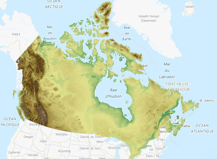
Canadian Digital Elevation Model, 1945-2011
This collection is a legacy product that is no longer supported. It may not meet current government standards.
The Canadian Digital Elevation Model (CDEM) is part of Natural Resources Canada's altimetry system designed to better meet the users' needs for elevation data and products.
The CDEM stems from the existing Canadian Digital Elevation Data (CDED). In these data, elevations can be either ground or reflective surface elevations.
A CDEM mosaic can be obtained for a pre-defined or user-defined extent. The coverage and resolution of a mosaic varies according to latitude and to the extent of the requested area.
Derived products such as slope, shaded relief and colour shaded relief maps can also be generated on demand by using the Geospatial-Data Extraction tool. Data can then be saved in many formats.
The pre-packaged GeoTiff datasets are based on the National Topographic System of Canada (NTS) at the 1:250 000 scale; the NTS index file is available in the Resources section in many formats.
Simple
- Date ( RI_366 )
- 2012-11-06
- Date ( RI_367 )
- 2015
- Presentation form
- modelDigital; modèleNumérique RI_393
- Status
- historicalArchive; archiveHistorique RI_594
- Maintenance and update frequency
- notPlanned; nonPlanifié RI_542
- Update scope
- dataset; jeuDonnées RI_622
- Keywords ( RI_525 )
-
- Canada
- Keywords ( RI_524 )
-
- Earth Sciences
- elevation
- relief
- geomatics
- Keywords ( RI_529 )
-
- GeoBase
- CDEM
- DEM
- CDED
- Government of Canada Core Subject Thesaurus Thésaurus des sujets de base du gouvernement du Canada ( RI_528 )
-
- Geographic information systems
- Geomatics
- Earth sciences
- Cartography
- Geography
- Geographic data
- Topography
- Use limitation
- Open Government Licence - Canada (http://open.canada.ca/en/open-government-licence-canada)
- Access constraints
- license; licence RI_606
- Use constraints
- license; licence RI_606
- Spatial representation type
- grid; grille RI_636
- Metadata language
- eng; CAN
- Metadata language
- fra; CAN
- Character set
- utf8; utf8 RI_458
- Topic category
-
- Elevation
))
- Begin date
- 1945
- End date
- 2011
- Reference system identifier
-
https://www.epsg-registry.org
/
EPSG:4617
/
8.6.2
- Date ( RI_366 )
- 2010-11-02
- Distribution format
-
-
WMS
(
1.3.0
)
- Specification
- Open Geospatial Consortium Inc., OpenGIS Web Map Service (WMS) Implementation Specification, Version 1.3.0, 2006-03-15, Reference number of this OGC® project document: 06-042 (https://portal.opengeospatial.org/files/?artifact_id=14416)
-
GeoTIF
(
N/A
)
- File decompression technique
- ZIP
-
ASCII Grid
(
N/A
)
-
WMS
(
1.3.0
)
- OnLine resource
-
Canadian Digital Elevation Model, Color Shaded Relief
(
OGC:WMS
)
Web Service;WMS;eng
- OnLine resource
-
Canadian Digital Elevation Model, Color Shaded Relief
(
OGC:WMS
)
Web Service;WMS;fra
- OnLine resource
-
Download directory to pre-packaged GeoTIFF files
(
HTTPS
)
Dataset;GeoTIF;eng,fra
- OnLine resource
-
Canadian Digital Elevation Model - Product Specifications
(
HTTPS
)
Supporting Document;PDF;fra
- OnLine resource
-
Cloud Optimized GeoTIFF of the CDEM
(
HTTPS
)
Dataset;GeoTIF;eng,fra
- OnLine resource
-
Cloud Optimized GeoTIFF of the CDEM hillshade
(
HTTPS
)
Dataset;GeoTIF;eng,fra
- OnLine resource
-
Canadian Digital Elevation Model - Product Specifications
(
HTTPS
)
Supporting Document;PDF;eng
- OnLine resource
-
CDEM product index (drag and drop the kmz file in Google Earth to localize your region of interest)
(
HTTPS
)
Supporting Document;KMZ;eng,fra
- OnLine resource
-
NTS Index (Use to identify the number of your area of interest)
(
HTTPS
)
Supporting Document;HTML;fra
- OnLine resource
-
NTS Index (Use to identify the number of your area of interest)
(
HTTPS
)
Supporting Document;HTML;eng
- OnLine resource
-
Documentation on the use of the Elevation API
(
HTTPS
)
Supporting Document;HTML;eng
- OnLine resource
-
Customized files and derived products in ASCII Grid format (Geospatial-Data Extraction tool)
(
HTTPS
)
Dataset;ASCII Grid;eng
- OnLine resource
-
Customized files and derived products in ASCII Grid format (Geospatial-Data Extraction tool)
(
HTTPS
)
Dataset;ASCII Grid;fra
- OnLine resource
-
Customized files and derived products in GeoTIFF format (Geospatial-Data Extraction tool)
(
HTTPS
)
Dataset;GeoTIF;fra
- OnLine resource
-
Customized files and derived products in GeoTIFF format (Geospatial-Data Extraction tool)
(
HTTPS
)
Dataset;GeoTIF;eng
- OnLine resource
-
Documentation on the use of the Elevation API
(
HTTPS
)
Supporting Document;HTML;fra
- Hierarchy level
- dataset; jeuDonnées RI_622
- Description
-
The source digital data for the CDEM are the existing Canadian Digital Elevation Data (CDED). The latter were extracted from the hypsographic and hydrographic elements of the National Topographic Data Base (NTDB) at the scale of 1:50 000, the Geospatial Database (GDB), various scaled positional data acquired by the provinces and territories, or remotely sensed imagery.
The horizontal reference system is the North American Datum of 1983 (NAD83 (CSRS)); the vertical reference system is the Canadian Geodetic Vertical Datum of 1928 (CGVD28)).
Metadata describing the source data and the product generation process is made available when extracting a CDEM mosaic.
- Date / Time
- 2013-04-01T00:00:00
- File identifier
- 7f245e4d-76c2-4caa-951a-45d1d2051333 XML
- Metadata language
- eng; CAN
- Character set
- utf8; utf8 RI_458
- Hierarchy level
- dataset; jeuDonnées RI_622
- Date stamp
- 2023-05-31T13:30:17
- Metadata standard name
- North American Profile of ISO 19115:2003 - Geographic information - Metadata
- Metadata standard version
- CAN/CGSB-171.100-2009
Overviews

Spatial extent
Provided by
