 Arctic SDI catalogue
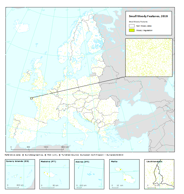
Small Woody Features 2018 (vector), Europe, 3-yearly, May 2023
Simple
- Date ( Publication )
- 2023-05-10
- Edition
- 1.0
- Identifier
- copernicus_v_3035_5_k_swf-2018_p_2017-2019_v01_r00
- Unique resource identifier
- 10.2909/7fd9d32e-8c2f-42b2-b959-c8e12b843821
Point of contact
- Maintenance and update frequency
- Continual
- GEMET - INSPIRE themes, version 1.0 ( Theme )
-
- Land cover
- Keywords
-
- Continents, countries, sea regions of the world. ( Place )
-
- EEA39
- Keywords
-
- GEMET ( Theme )
-
- land use
- land
- landscape alteration
- landscape
- land cover
- Spatial scope ( Theme )
- EEA topics ( Theme )
- Access constraints
- Other restrictions
- Other constraints
- no limitations to public access
- Use constraints
- Other restrictions
- Other constraints
-
The Copernicus component is governed by Regulation (EU) No 2021/696 of the European Parliament and of the Council of 28 April 2021 establishing the Union Space Programme and the European Union Agency for the Space Programme and repealing Regulations (EU) No 912/2010, (EU) No 1285/2013 and (EU) No 377/2014 and Decision No 541/2014/EU. Within the Copernicus component, a portfolio of land monitoring activities has been delegated by the European Union to the European Environment Agency (EEA) and the DG Joint Research Centre of the European Commission.
The Copernicus land monitoring products and services are made available on a principle of full, open and free access, as established by the Commission Delegated Regulation (EU) No 1159/2013 of 12 July 2013.
Free, full and open access to the products and services of the Copernicus Land Monitoring Service is made on the conditions that:
1. When distributing or communicating Copernicus Land Monitoring Service products and services (data, software scripts, web services, user and methodological documentation and similar) to the public, users shall inform the public of the source of these products and services.
2. Where the Copernicus Land Monitoring Service products and services have been adapted or modified by the user, the user shall clearly state this.
3. Users shall make sure not to convey the impression to the public that the user's activities are officially endorsed by the European Union.
- Spatial representation type
- vector Vector
- Metadata language
- en
- Character set
- utf8 UTF8
- Topic category
-
- Environment
- Imagery base maps earth cover
))
- Begin date
- 2017-01-01
- End date
- 2019-12-31
- Unique resource identifier
- EPSG:3035
- Distribution format
-
-
GDB
(
)
-
Geopackage
(
)
-
GDB
(
)
- OnLine resource
- Product Information & Technical Documentation ( WWW:LINK )
- OnLine resource
-
CLMS Website
(
WWW:DOWNLOAD
)
Download (requires authentication)
- OnLine resource
- https://doi.org/10.2909/7fd9d32e-8c2f-42b2-b959-c8e12b843821 ( DOI )
OnLine resource
- Hierarchy level
- Dataset
Conformance result
- Date ( Publication )
- 2023-05-10
- Explanation
- See the referenced specification
Absolute external positional accuracy
- Name of measure
- Minimum Mapping Width
Quantitative result
- Value
- 30
Absolute external positional accuracy
- Name of measure
- Minimum Mapping Unit
Quantitative result
- Value
- 0.02
- Statement
-
The HRL Small Woody Feature Vector Product is primarily based on a supervised classification of satellite image time-series from VHR_IMAGE_2018 acquired from May 2017 to September 2019.
Geometric specifications: For the linear elements no MMU is applied. For patchy structures of trees and scrub the MMU is > 200 m2 (size limit of 50 000m2). The MMW for linear structures/elements is < 30m. The MML for linear structures/elements is of > 30 m length. For Patchy structures no MML is applied.
The positional accuracy is less than 5 m.
Quality assurance follows the ISO 9001:2015 standards for Quality Management and comprises of dedicated procedures of quality checks (QA breakpoints) during implementation of the production chain, in order to keep persistent control over the various stages of production, assure fitness-for-purpose of the end-products and that all quality requirements are fulfilled. Priority has been given to the target thematic accuracy to be achieved by each product, as well as to the issues of product consistency (spatial, thematic, temporal) and homogeneity.
Quality Assessment: The quality assessment has been performed according to INSPIRE Data Specifications. The data quality elements considered are: (i) Completeness, (ii) Logical Consistency, (iii) positional accuracy, (iv) Thematic Accuracy, (v) Temporal quality and (vi) Usability.
Accuracy assessment approach: stratified random point sampling. Interpretation of sampling points has been performed on the best available reference data. The general accuracy level of the HRL SWF products shall be in the order of 80 % for Overall thematic Accuracy, User’s Accuracy and Producer’s Accuracy.
- File identifier
- 7fd9d32e-8c2f-42b2-b959-c8e12b843821 XML
- Metadata language
- en
- Character set
- UTF8
- Hierarchy level
- Dataset
- Date stamp
- 2025-10-09T11:00:07.646445Z
- Metadata standard name
- ISO 19115/19139
- Metadata standard version
- 1.0
Overviews
Spatial extent
Provided by
