 Arctic SDI catalogue
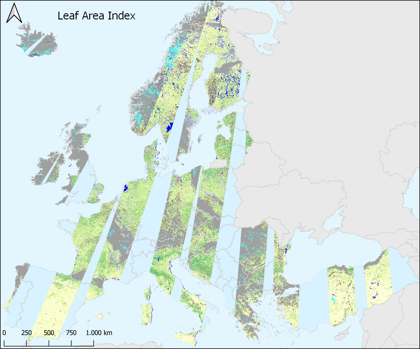
High Resolution Vegetation Phenology and Productivity: Leaf Area Index (raster 10m) version 1 revision 1, Sep. 2021
This metadata refers to the Leaf Area Index (LAI) dataset, one of the near real-time (NRT) Vegetation Index products of the pan-European High Resolution Vegetation Phenology and Productivity (HR-VPP), component of the Copernicus Land Monitoring Service (CLMS).
The Leaf Area Index (LAI) is defined as half the total area of green elements of the canopy per unit horizontal ground area.
The satellite-derived value corresponds to the total green LAI of all the canopy layers, including the understory which may represent a very significant contribution, particularly for forests.
The LAI dataset is made available as raster files with 10 x 10m resolution, in UTM/WGS84 projection corresponding to the Sentinel-2 tiling grid, for those tiles that cover the EEA38 countries and the United Kingdom and for the period from October 2016 until today, with daily updates.
Each file has an associated quality indicator (QFLAG2) to assist users with the screening of clouds, shadows from clouds and topography, snow and water surfaces.
Simple
- Date ( Publication )
- 2021-09-02
- Date ( Creation )
- 2021-09-02
- Edition
- 01.01
- Identifier
- copernicus_r_utm-wgs84_10_m_hrvpp-vi-lai_p_2016-now_v01_r01
- Maintenance and update frequency
- Continual
- GEMET - INSPIRE themes, version 1.0 ( Theme )
- Keywords
-
- Keywords
-
- GEMET ( Theme )
-
- leaf
- vegetation
- land
- plant ecology
- index
- plant production
- remote sensing
- Spatial scope ( Theme )
- Temporal resolution ( Temporal )
-
- Daily
- Continents, countries, sea regions of the world. ( Place )
-
- United Kingdom
- EEA38 (from 2020)
- EEA topics ( Theme )
-
- Biodiversity
- Agriculture and food
- Land use
- Access constraints
- Other restrictions
- Other constraints
- no limitations to public access
- Use constraints
- Other restrictions
- Other constraints
-
The Copernicus component is governed by Regulation (EU) No 2021/696 of the European Parliament and of the Council of 28 April 2021 establishing the Union Space Programme and the European Union Agency for the Space Programme and repealing Regulations (EU) No 912/2010, (EU) No 1285/2013 and (EU) No 377/2014 and Decision No 541/2014/EU. Within the Copernicus component, a portfolio of land monitoring activities has been delegated by the European Union to the European Environment Agency (EEA) and the DG Joint Research Centre of the European Commission.
The Copernicus land monitoring products and services are made available on a principle of full, open and free access, as established by the Commission Delegated Regulation (EU) No 1159/2013 of 12 July 2013.
Free, full and open access to the products and services of the Copernicus Land Monitoring Service is made on the conditions that:
1. When distributing or communicating Copernicus Land Monitoring Service products and services (data, software scripts, web services, user and methodological documentation and similar) to the public, users shall inform the public of the source of these products and services.
2. Where the Copernicus Land Monitoring Service products and services have been adapted or modified by the user, the user shall clearly state this.
3. Users shall make sure not to convey the impression to the public that the user's activities are officially endorsed by the European Union.
- Aggregate Datasetindentifier
- copernicus_r_utm-wgs84_10_m_hrvpp-vi-qflag2_p_2017-ongoing_v01_r01
- Association Type
- Cross reference
- Aggregate Datasetindentifier
- copernicus_r_utm-wgs84_10_m_hrvpp-vi-ndvi_p_2017-ongoing_v01_r01
- Association Type
- Cross reference
- Aggregate Datasetindentifier
- copernicus_r_utm-wgs84_10_m_hrvpp-vi-fapar_p_2017-ongoing_v01_r01
- Association Type
- Cross reference
- Aggregate Datasetindentifier
- copernicus_r_utm-wgs84_10_m_hrvpp-vi-lai_p_2017-ongoing_v01_r01
- Association Type
- Cross reference
- Spatial representation type
- Grid
- Distance
- 10 m
- Metadata language
- en
- Character set
- UTF8
- Topic category
-
- Environment
- Imagery base maps earth cover
- Climatology, meteorology, atmosphere
))
- Begin date
- 2016-10-01
- Unique resource identifier
- EPSG:32625
- Unique resource identifier
- EPSG:32626
- Unique resource identifier
- EPSG:32627
- Unique resource identifier
- EPSG:32628
- Unique resource identifier
- EPSG:32629
- Unique resource identifier
- EPSG:32630
- Unique resource identifier
- EPSG:32631
- Unique resource identifier
- EPSG:32632
- Unique resource identifier
- EPSG:32633
- Unique resource identifier
- EPSG:32634
- Unique resource identifier
- EPSG:32635
- Unique resource identifier
- EPSG:32636
- Unique resource identifier
- EPSG:32637
- Unique resource identifier
- EPSG:32638
- Distribution format
-
-
GeoTIFF
(
1.0
)
-
GeoTIFF
(
1.0
)
- OnLine resource
- WEkEO portal ( WWW:LINK-1.0-http--link )
- OnLine resource
-
CLMS_HRVPP_VI_LAI_10M
(
OGC:WMTS
)
CLMS_HRVPP_VI_LAI_10M
- OnLine resource
-
Harmonized Data Access (WEkEO)
(
WWW:LINK-1.0-http--link
)
Harmonized Data Access (WEkEO)
- OnLine resource
- OpenSearch API ( OGC:OpenSearch )
- OnLine resource
- Product information ( WWW:LINK-1.0-http--link )
- OnLine resource
- Product user manual ( WWW:LINK-1.0-http--link )
- OnLine resource
-
CLMS_HRVPP_VI_LAI_10M
(
OGC:WMS
)
CLMS_HRVPP_VI_LAI_10M
- OnLine resource
- Download (requires authentication) ( WWW:LINK-1.0-http--link )
- Hierarchy level
- Dataset
Conformance result
- Date ( Publication )
- 2010-12-08
- Explanation
- See the referenced specification
- Statement
- Comprehensive information about the product and its documentation can be accessed by following the links provided in the Links section.
- File identifier
- 8174a95b-29ad-4d9c-95e7-a1e0a6d94aca XML
- Metadata language
- en
- Character set
- UTF8
- Hierarchy level
- Dataset
- Date stamp
- 2024-02-06T16:46:00.964Z
- Metadata standard name
- ISO 19115/19139
- Metadata standard version
- 1.0
Overviews
Spatial extent
Provided by
