 Arctic SDI catalogue
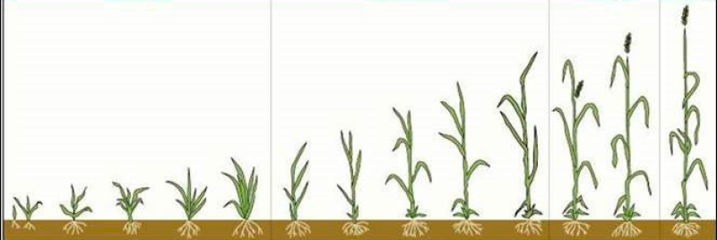
Crop Development Stage
Crop development stage in a numerical scale. All living organisms move from one stage of development to the next over time. For annual crops, it life cycle (growing season) completed within a year. Crop water use differs from one stage to another mostly due to the differences in the amount of green leaves, thus crop stage is closely related to its water consumption and water stress condition. Crop stages are mostly controlled by growing season heat accumulation and regulated by day-length crop some crops. The crop stages provided here are determined by a biometeorlogical time scale model (Robertson, 1968) for cool season crops (wheat, barley etc.) , and a Crop Heat Unit (Brown and Bootsma, 1993) algorithm for warm season crops (corn and soybean etc.).
Simple
- Date ( RI_367 )
- 2018-06-01
- Date ( RI_366 )
- 2018-06-01
- Status
- completed; complété RI_593
- Maintenance and update frequency
- asNeeded; auBesoin RI_540
- Government of Canada Core Subject Thesaurus Thésaurus des sujets de base du gouvernement du Canada ( RI_528 )
-
- Agriculture
- Crops
- Use limitation
- Open Government Licence - Canada (http://open.canada.ca/en/open-government-licence-canada)
- Access constraints
- license; licence RI_606
- Use constraints
- license; licence RI_606
- Spatial representation type
- grid; grille RI_636
- Metadata language
- eng; CAN
- Topic category
-
- Farming
- Begin date
- 1976-12-01
N
S
E
W
))
- Reference system identifier
- http://www.epsg-registry.org / EPSG:4326 /
- Distribution format
-
-
TIFF
(
2.0
)
-
TIFF
(
2.0
)
- OnLine resource
-
Data Product Specification (English)
(
HTTPS
)
Supporting Document;PDF;eng
- OnLine resource
-
Data Product Specification (French)
(
HTTPS
)
Supporting Document;PDF;fra
- OnLine resource
-
Pre-packaged GeoTIF files
(
HTTPS
)
Dataset;GeoTIF;zxx
- File identifier
- 84d1ff0d-4689-466c-b792-f860a1fb1603 XML
- Metadata language
- eng; CAN
- Character set
- utf8; utf8 RI_458
- Parent identifier
- Crop Health Indices 7f835844-3774-4323-b20e-a898c9f20136
- Hierarchy level
- series; série RI_623
- Date stamp
- 2026-02-25T12:25:17
- Metadata standard name
- North American Profile of ISO 19115:2003 - Geographic information - Metadata
- Metadata standard version
- CAN/CGSB-171.100-2009
Overviews

thumbnail
large_thumbnail
thumbnail_fre
large_thumbnail_fre
Spatial extent
N
S
E
W
Provided by

Associated resources
Not available