 Arctic SDI catalogue
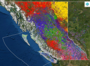
BC Tree Species Map/Likelihoods (2015)
Dominant Species Map 2015
The data represent dominant tree species for British Columbia forests in 2015, are based upon Landsat data and modeling, with results mapped at 30 m spatial resolution. It is developed within the framework of Canada’s National Terrestrial Ecosystem Monitoring System (NTEMS). The map was generated with the Random Forests classifier that used predictor variables derived from Landsat time series including surface reflectance, land cover, forest disturbance, and forest structure, and ancillary variables describing the topography and position. Training and validation samples were derived from the Vegetation Resources Inventory (VRI), from a pool of polygons with homogeneous internal conditions and with low discrepancies with the remotely sensed predictions. Local models were applied over 100x100 km tiles that considered training samples from the 5x5 neighbouring tiles to avoid edge effects. An overall accuracy of 72% was found for the species which occupy 80% of the forested areas. Satellite data and modeling have demonstrated the capacity for up-to-date, wall-to-wall, forest attribute maps at sub-stand level for British Columbia, Canada.
BC Species Likelihood 2015
The tree species class membership likelihood distribution data included in this product focused on the province of British Columbia, based upon Landsat data and modeling, with results mapped at 30 m spatial resolution. The data represent tree species class membership likelihood in 2015. The map was generated with the Random Forests classifier that used predictor variables derived from Landsat time series including surface reflectance, land cover, forest disturbance, and forest structure, and ancillary variables describing the topography and position. Training and validation samples were derived from the Vegetation Resources Inventory (VRI) selecting from a stratified pool of polygons with homogeneous internal conditions and with low discrepancies when related to remotely sensed information. Local models were applied over 100x100 km tiles that, to avoid edge effects, considered training samples from the 5x5 neighbouring tiles. An overall accuracy of 72% was found for the species which occupy 80% of the forested areas. As an element of the mapping process, we also obtain the votes received for each class by the Random Forest models. The votes can be understood as analogous to class membership likelihoods, providing enriched information on land cover class uncertainty for use in modeling. Tree species class membership likelihoods lower than 5% have been masked and converted to zero.
When using this data, please cite as: Shang, C., Coops, N.C., Wulder, M.A., White, J.C., Hermosilla, T., 2020. Update and spatial extension of strategic forest inventories using time series remote sensing and modeling. International Journal of Applied Earth Observation and Geoinformation 84, 101956. DOI: 10.1016/j.jag.2019.101956 ( Shang et al. 2020).
Simple
- Date ( RI_367 )
- 2020
- Date ( RI_366 )
- 2020
(250) 363-6004
https://cfs.nrcan.gc.ca/employes/vue/mwulder
- Hours of service
- email only please
- Status
- onGoing; enContinue RI_596
- Maintenance and update frequency
- asNeeded; auBesoin RI_540
- Keywords
-
- National Terrestrial Ecosystem Monitoring System (NTEMS)
- Government of Canada Core Subject Thesaurus Thésaurus des sujets de base du gouvernement du Canada ( RI_528 )
-
- Forests
- Use limitation
- Open Government Licence - Canada (http://open.canada.ca/en/open-government-licence-canada)
- Access constraints
- otherRestrictions; autresRestrictions RI_609
- Use constraints
- intellectualPropertyRights; droitsPropriétéIntellectuelle RI_607
- Other constraints
- Les données représentant les espèces d’arbres dominantes des forêts de la Colombie-Britannique en 2015 sont fondées sur des données Landsat et leur modélisation, dont les résultats sont cartographiés à une résolution spatiale de 30 m. La carte a été produite par l’algorithme de classification des « forêts aléatoires » appliqué à des variables prédictives calculées à partir de séries chronologiques d’images Landsat, notamment la réflectance de la surface, la couverture terrestre, les perturbations forestières et la structure de la forêt, ainsi qu’à des variables accessoires décrivant la topographie et la position. Les échantillons d’entraînement et de validation ont été tirés de l’Inventaire des ressources végétales (Vegetation Resources Inventory), sélectionnés parmi un ensemble stratifié de polygones présentant des conditions internes homogènes et divergeant peu par rapport aux données de télédétection. Des modèles locaux ont été appliqués à des carrés de 100 km x 100 km et, pour éviter les effets de bordure, tenaient compte des échantillons d’entraînement pour les 5 x 5 carrés voisins. Pour les espèces d’arbres qui occupent 80 % de la superficie forestière, l’exactitude globale s’est chiffrée à 72 %. L’étude montre que les données satellitaires et leur modélisation peuvent servir à produire des cartes complètes et à jour des attributs forestiers à l’échelle des sous peuplements en Colombie Britannique (Canada).
- Spatial representation type
- grid; grille RI_636
- Metadata language
- eng
- Topic category
-
- Geoscientific information
- Begin date
- 2015
- End date
- 2015
))
- Reference system identifier
- http://www.epsg-registry.org / EPSG:3978 / 1.0
- Distribution format
-
-
GeoTIF
(
1.0
)
-
GeoTIF
(
1.0
)
(250) 363-6004
https://ca.nfis.org/index_eng.html
- Hours of service
- email only please
- OnLine resource
-
A nationwide annual characterization of 25 years of forest disturbance and recovery for Canada using Landsat time series
(
HTTP
)
Supporting Document;HTML;eng
- OnLine resource
-
BC_tree_species_map_2015
(
OGC:WMS
)
Web Service;WMS;fra
- OnLine resource
-
BC_tree_species_map_2015
(
OGC:WMS
)
Web Service;WMS;eng
- OnLine resource
-
Update and spatial extension of strategic forest inventories using time series remote sensing and modeling
(
HTTP
)
Supporting Document;PDF;eng
- OnLine resource
-
BC Tree Species Map/Likelihoods 2015
(
HTTPS
)
Dataset;ZIP;eng
- File identifier
- 8dddaa7f-c60d-4802-a662-2930c5aeedb8 XML
- Metadata language
- eng; CAN
- Character set
- utf8; utf8 RI_458
- Hierarchy level
- dataset; jeuDonnées RI_622
- Date stamp
- 2026-02-17T10:07:00
- Metadata standard name
- North American Profile of ISO 19115:2003 - Geographic information - Metadata
- Metadata standard version
- CAN/CGSB-171.100-2009
(250) 363-6004
https://cfs.nrcan.gc.ca/employes/vue/mwulder
- Hours of service
- email only please
Overviews


Spatial extent
Provided by
