 Arctic SDI catalogue
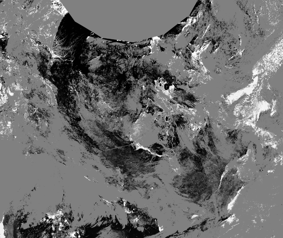
Daily NDVI and Snow Mask Composite Products from VIIRS SNPP
The dataset includes two data products derived from the Visible Infrared Imaging Radiometer Suite (VIIRS) imager operated by the US National Oceanic and Atmospheric Administration (NOAA) onboard Suomi National Polar-Orbiting Partnership (SNPP) satellite:
1) Normalized Difference Vegetation Index (NDVI)
2) Snow Mask (Snow) with supplementary information about data quality and scene identification
Each product, NDVI and Snow, has been derived at two spatial resolutions:
1) I-band resolution for 250-m spatial grid (VIIRS image bands I1 and I2)
2) M-band resolution for 500-m spatial grid (VIIRS moderate resolution bands M5 and M7)
Datasets are produced with a daily temporal frequency, i.e. one file per day. The study area with the size of 5,700 km × 4,800 km covers Canada and neighboring regions (Trishchenko, 2019). The VIIRS time series are produced from VIIRS /SNPP imagery at CCRS from January 1, 2017.
Simple
- Date ( RI_367 )
- 2022-07-19T14:06:00
- Date ( RI_366 )
- 2022-01-01
- Status
- completed; complété RI_593
- Maintenance and update frequency
- biannually; semestriel RI_538
- Keywords ( RI_528 )
-
- Vegetation
- Snow
- Normalized Difference Vegetation Index, NDVI
- Government of Canada Core Subject Thesaurus Thésaurus des sujets de base du gouvernement du Canada ( RI_528 )
-
- Satellite images
- Remote sensing
- Use limitation
- Open Government Licence - Canada (http://open.canada.ca/en/open-government-licence-canada)
- Access constraints
- license; licence RI_606
- Use constraints
- license; licence RI_606
- Spatial representation type
- grid; grille RI_636
- Metadata language
- eng; CAN
- Topic category
-
- Imagery base maps earth cover
- Begin date
- 2017-01-01
- End date
- 2022-06-30
))
- Reference system identifier
- / unknown /
- Distribution format
-
-
GeoTIF
(
Unknown
)
-
GeoTIF
(
Unknown
)
- OnLine resource
-
Abstract - Daily NDVI and Snow Mask Composite Products from VIIRS SNPP
(
HTTPS
)
Supporting Document;DOCX;eng
- OnLine resource
-
Abstract - Daily NDVI and Snow Mask Composite Products from VIIRS SNPP
(
HTTPS
)
Supporting Document;DOCX;fra
- OnLine resource
-
2022 I-band 250m
(
HTTPS
)
Dataset;GeoTIF;zxx
- OnLine resource
-
2022 M-band 500m
(
HTTPS
)
Dataset;GeoTIF;zxx
- OnLine resource
-
2021 I-band 250m
(
HTTPS
)
Dataset;GeoTIF;zxx
- OnLine resource
-
2021 M-band 500m
(
HTTPS
)
Dataset;GeoTIF;zxx
- OnLine resource
-
2020 I-band 250m
(
HTTPS
)
Dataset;GeoTIF;zxx
- OnLine resource
-
2020 M-band 500m
(
HTTPS
)
Dataset;GeoTIF;zxx
- OnLine resource
-
2019 I-band 250m
(
HTTPS
)
Dataset;GeoTIF;zxx
- OnLine resource
-
2019 M-band 500m
(
HTTPS
)
Dataset;GeoTIF;zxx
- OnLine resource
-
2018 I-band 250m
(
HTTPS
)
Dataset;GeoTIF;zxx
- OnLine resource
-
2018 M-band 500m
(
HTTPS
)
Dataset;GeoTIF;zxx
- OnLine resource
-
2017 I-band 250m
(
HTTPS
)
Dataset;GeoTIF;zxx
- OnLine resource
-
2017 M-band 500m
(
HTTPS
)
Dataset;GeoTIF;zxx
- File identifier
- 90882264-f1e1-45e2-8e29-84b41f4d65e3 XML
- Metadata language
- eng; CAN
- Character set
- utf8; utf8 RI_458
- Hierarchy level
- dataset; jeuDonnées RI_622
- Date stamp
- 2022-10-28T15:49:22
- Metadata standard name
- North American Profile of ISO 19115:2003 - Geographic information - Metadata
- Metadata standard version
- CAN/CGSB-171.100-2009
Overviews
Spatial extent
Provided by
