 Arctic SDI catalogue
Marine Seismic Survey Profiles (MSSP) (WMS)
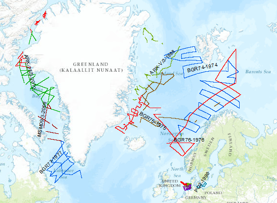
During the period from 1974 to 2010 various cruises from BGR acquired seismic lines worldwide. The aim of these marine expeditions was a detailed survey of the geological structure.
Simple
Identification info
- Alternate title
- MSSP (WMS)
- Date ( Creation )
- 2015-01-01
- Identifier
- 4b34d51c-2b1a-421b-8659-dbb31a43c0f9
- Status
- Completed
Point of contact
Federal Institute for Geosciences and Natural Resources
Stilleweg 2
,
Hannover
,
30655
,
Germany
- GEMET - Concepts, version 2.4 GEMET - Concepts, version 2.4 ( Theme )
-
- raw material
- Rohstoff
- marine geology
- Meeresgeologie
- geophysics
- Geophysik
- GEMET - INSPIRE themes, version 1.0 GEMET - INSPIRE themes, version 1.0 ( Theme )
-
- geology
- Geologie
- Keywords ( Theme )
-
- two-dimensional seismic reflection
- zweidimensionale Reflektionsseismik
- seismics
- Seismik
- MSSP
- infoMapAccessService
- Keywords ( Place )
-
- North Sea
- Nordsee
- Baltic Sea
- Ostsee
- Arctic Ocean
- Arktis
- North Atlantic
- Nordatlantik
- Barentssea
- Barentssee
- Norwegian Sea
- Norwegische See
- Labrador Sea
- Labradorsee
- Baffin Bay
- Baffin Bucht
- Laptev Sea
- Laptevsee
Resource constraints
No information provided.
Resource constraints
No information provided.
Resource constraints
No information provided.
Resource constraints
No information provided.
Resource constraints
No information provided.
Resource constraints
No information provided.
Resource constraints
No information provided.
Resource constraints
No information provided.
Resource constraints
No information provided.
Resource constraints
No information provided.
Resource constraints
No information provided.
Resource constraints
No information provided.
- Classification
- Unclassified
- Use limitation
- Allgemeine Geschäftsbedingungen, siehe https://www.bgr.bund.de/AGB - General terms and conditions, see https://www.bgr.bund.de/AGB_en. Die bereitgestellten Informationen sind bei Weiterverwendung wie folgt zu zitieren: Datenquelle: MSSP, (c) BGR, Hannover, 2015
- Access constraints
- Copyright
- Service Type
- view
- Service Version
- OGC:WMS 1.3.0
N
S
E
W
))
Coupled Resource
- Operation Name
- GetMap
- Identifier
- b2c0c25b-1a34-42cb-bcfb-8314a7e3bb6e
- Coupling Type
- Tight
Contains Operations
- Operation Name
- GetCapabilities
- Distributed Computing Platforms
- WebService
- Connect Point
- https://services.bgr.de/wms/marineseismik/mssp/?
Contains Operations
- Operation Name
- GetMap
- Distributed Computing Platforms
- WebService
- Connect Point
- https://services.bgr.de/wms/marineseismik/mssp/?
- Operates On
- Reference system identifier
- / 4326 /
- Distribution format
-
-
png
(
n/a
)
-
jpeg
(
n/a
)
-
gif
(
n/a
)
-
png
(
n/a
)
- OnLine resource
- https://services.bgr.de/wms/marineseismik/mssp/?REQUEST=GetCapabilities&SERVICE=wms&VERSION=1.3.0
- OnLine resource
-
Karte im BGR-Geoviewer
Karte im BGR-Geoviewer
- Hierarchy level
- Service
Conformance result
- Date ( Publication )
- 2010-12-08
- Explanation
- siehe dazu die angegebene Durchführungsbestimmung
- Statement
- The described lines are the routes of the research vessel. Along these lines profiles are surveyed by a high-resolution multichannel seismic system and stored in SEG Y format, which are available at BGR as processed (migrated/stacked) or raw data.
- File identifier
- 97d436ad-0076-4b32-8d4f-4353e8f3ae01 XML
- Metadata language
- en
- Character set
- UTF8
- Hierarchy level
- Service
- Hierarchy level name
- Geophysik
- Date stamp
- 2020-07-14
- Metadata standard name
- INSPIRE Metadata Implementing Rules: Technical Guidelines based on EN ISO 19115 and EN ISO 19119
- Metadata standard version
- V. 1.2
Overviews
Spatial extent
N
S
E
W
Provided by

Associated resources
Not available