 Arctic SDI catalogue
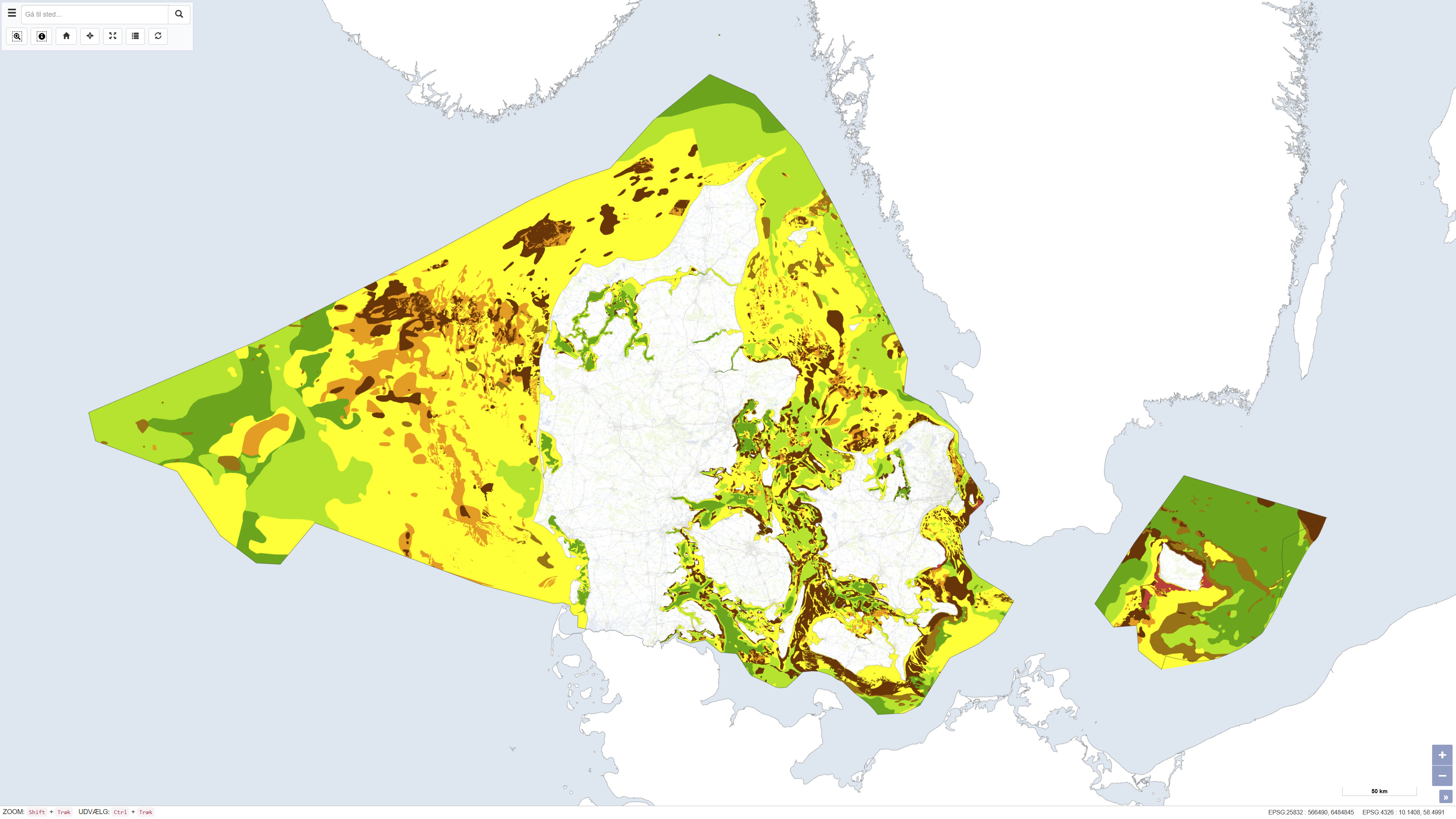
Seabed Sediment Map of Denmark
The seabed sediment map shows the distribution of seabed sediments in Danish waters and represents an integrated interpretation of sediment types within the upper approximately 0.5 metres of the seabed. Sediment classes are defined based on grain-size composition and reflect an average of the surface sediments. Glacial till is classified as a mixed sediment, while sedimentary bedrock indicates areas where deposits several million years old are exposed on the seabed.
The map was updated in 2020 and builds upon the previous version from 2014, with newly mapped areas added at full level of detail. The dataset provides a nationwide overview of seabed sedimentary conditions and is used, among other purposes, for raw material mapping, marine spatial planning, and environmental assessments.
Simple
- Date ( Publication )
- 2020-01-01
- Identifier
- dk.geus / dk_seabed_sediment_map
- Presentation form
- Digital map
- Purpose
- The purpose of the dataset is to provide a coherent and updated overview of the distribution of seabed sediments in Danish waters. The map is suitable for use in marine raw material mapping, marine spatial planning, environmental management, research, and as a scientific basis for analyses of physical and biological seabed conditions.
- Status
- Completed
- Maintenance and update frequency
- As needed
- Keywords ( Theme )
-
- Dataset
- Marine geology
- Seabed sediments
- Raw materials
- Denmark
- ArcGIS
- QGIS
- Forskningsemner Forskningsemner ( Theme )
- Geografisk Geografisk ( Place )
- Access constraints
- Other restrictions
- Use constraints
- Other restrictions
- Other constraints
- CC BY 4.0
- Spatial representation type
- Vector
- Denominator
- 500000
- Metadata language
- Da
- Character set
- UTF8
- Topic category
-
- Geoscientific information
- Begin date
- 2020-01-01
- End date
- 2020-12-31
))
- Supplemental Information
- The dataset represents a generalised interpretation of seabed surface sediments based on available data and expert assessment. The map is not subject to continuous updates and should be used in conjunction with local surveys and more recent data for detailed analyses.
- Reference system identifier
- ETRS 89 / UTM 32N (EPSG:25832)
- Distribution format
-
-
WMS
(
)
-
WMTS
(
)
-
REST
(
)
-
WMS
(
)
- OnLine resource
-
Download
(
WWW:DOWNLOAD-1.0-http--download
)
Download dataset from GEUS' Dataverse
- OnLine resource
-
Interactive webmap
(
WWW:LINK-1.0-http--link
)
Interactive map displaying the dataset.
- OnLine resource
-
Seabed sediment map – Geoviden 2014, No. 2
(
WWW:LINK-1.0-http--link
)
Article describing the previous 2014 version of the seabed sediment map and its scientific basis.
- OnLine resource
-
New digital seabed sediment map
(
WWW:LINK-1.0-http--link
)
GEUS publication presenting the background, methodology, and applications of the digital seabed sediment map.
- OnLine resource
-
Seabed surface sediments
(
WWW:LINK-1.0-http--link
)
GEUS webpage providing general information on seabed surface sediments and their relevance for raw material mapping.
- OnLine resource
-
Havbundssediment
(
ESRI:REST
)
ArcGIS REST Service
- OnLine resource
-
Denmark_Havbundssediment
(
OGC:WMTS-1.0.0-http-get-capabilities
)
ArcGIS WMTS Service
- OnLine resource
-
Marinsediment
(
OGC:WMS-1.3.0-http-get-capabilities
)
ArcGIS WMS Service
- Hierarchy level
- Dataset
- Statement
- The map is primarily based on seismic and acoustic background data calibrated using seabed sediment samples. Data coverage varies significantly across Danish waters, and interpretations therefore rely extensively on interpolation between data points. Geological knowledge of sedimentary formation processes, together with detailed bathymetric data, has been used to delineate sediment boundaries. In addition, biological information on the distribution of benthic algae, eelgrass, and mussels has been incorporated as supplementary evidence, as these organisms provide indirect indications of seabed substrate. The 2020 version represents an update of the 2014 map, with newly mapped areas added at full mapping detail.
- File identifier
- 98e75789-2512-4961-8985-e23d91ef4dd7 XML
- Metadata language
- Danskda
- Character set
- UTF8
- Hierarchy level
- Dataset
- Date stamp
- 2026-02-11T13:21:05.808082Z
- Metadata standard name
- ISO 19115:2003/19139
- Metadata standard version
- 1.0
Overviews
Spatial extent
Provided by
