 Arctic SDI catalogue
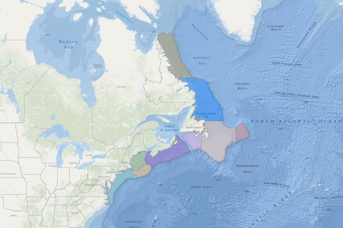
Ecosystem Production Units in the Northwest Atlantic Ocean
Pepin et al. (2014) stated that three nested spatial scales were identified as relevant for the development of ecosystem summaries and management plans: Bioregion, Ecosystem Production Unit (EPU), and Ecoregion. A bioregion is composed by one or more EPUs, while an EPU consists of a combination of ecoregions, which represent elements with different physical and biological characteristics based on the analytical criteria applied. Pepin et al. (2014) reported on the consolidation of data and analyses of ecoregion structure for the continental shelf areas from the Labrador Sea to the mid-Atlantic Bight and provided recommendations on the definition of EPUs in the NAFO Convention Area.
The results of two K-means clustering analyses (one geographically constrained and one un-constrained) and expert knowledge (including and considering location of ecoregions, knowledge of the distribution of major marine resources and fish stocks, and geographic proximity for delineation/definition of potential management units) served as guides for evaluation by NAFO’s (North Atlantic Fisheries Organization) working group on ecosystem science and assessments (WG-ESA). The final consensus from the discussions identified eight (8) major EPUs that can serve as practical candidate management units (from the 50 m isobaths, where research vessel data were available, seaward to the 1500 m isobaths) that consist of the Labrador Shelf (NAFO subareas 2GH), the northeast Newfoundland Shelf (subareas 2J3K), the Grand Banks (subareas 3LNO), Flemish Cap (subarea 3M), the Scotian Shelf (subareas 4VnsWX), Georges Bank (parts of subareas 5Ze and 5Zw), the Gulf of Maine (subarea 5Y and part of 5Ze) and the mid-Atlantic Bight (part of subarea 5Zw and subareas 6ABC). Southern Newfoundland (subarea 3Ps) was not included in the original analysis because fall survey data were unavailable. However, it was later added as an EPU after additional analysis of the fish community structure and trends using survey data from the spring, which indicated that this area is heavily influenced by the surrounding EPUs (NAFO 2015).
The proposed candidate management units correspond to the EPUs that define major areas within the bioregions which contain a reasonably well defined food web/production system. The working group noted that the consensus solution represents a compromise that aims to define management units based on the boundaries of existing NAFO subareas that are appropriate for estimation of ecosystem and fishery production.
References:
NAFO. 2015. Report of the 8th Meeting of the NAFO Scientific Council (SC) Working Group on Ecosystem Science and Assessment (WGESA). 17-26 November 2015, Dartmouth, Canada. NAFO SCS Doc. 15/19.
Pepin, P., Higdon, J., Koen-Alonso, M., Fogarty, M., and N. Ollerhead. 2014. Application of ecoregion analysis to the identification of Ecosystem Production Units (EPUs) in the NAFO Convention Area. NAFO SCR Doc. 14/069.
Simple
- Date ( RI_367 )
- 2014
- Date ( RI_366 )
- 2014
- Status
- completed; complété RI_593
- Maintenance and update frequency
- asNeeded; auBesoin RI_540
- Government of Canada Core Subject Thesaurus Thésaurus des sujets de base du gouvernement du Canada ( RI_528 )
-
- Ecology
- Boundaries
- Production
- Environment
- Oceans
- Classification
- unclassified; nonClassifié RI_484
- Use limitation
- Open Government Licence - Canada (http://open.canada.ca/en/open-government-licence-canada)
- Access constraints
- license; licence RI_606
- Use constraints
- license; licence RI_606
- Spatial representation type
- vector; vecteur RI_635
- Metadata language
- eng; CAN
- Character set
- utf8; utf8 RI_458
- Topic category
-
- Biota
- Environment
- Boundaries
- Geoscientific information
- Oceans
- Begin date
- 2014
- End date
- 2014
))
- Reference system identifier
- http://www.epsg-registry.org / EPSG:4326 /
- Distribution format
-
-
SHP
(
unknown
)
-
SHP
(
unknown
)
- OnLine resource
-
Data Dictionary
(
HTTPS
)
Supporting Document;CSV;eng,fra
- OnLine resource
-
Ecosystem Science and Assessment Working Group Report
(
HTTPS
)
Supporting Document;PDF;eng
- OnLine resource
-
Ecosystem Production Units in the Northwest Atlantic Ocean
(
HTTPS
)
Dataset;SHP;eng,fra
- OnLine resource
-
Ecosystem Production Units Report
(
HTTPS
)
Supporting Document;PDF;eng
- OnLine resource
-
Ecosystem Production Units in the Northwest Atlantic Ocean
(
ESRI REST: Map Server
)
Web Service;ESRI REST;eng
- OnLine resource
-
Ecosystem Production Units in the Northwest Atlantic Ocean
(
ESRI REST: Map Server
)
Web Service;ESRI REST;fra
- File identifier
- 9a515ef8-0e2a-479e-9b25-55658eae30be XML
- Metadata language
- eng; CAN
- Character set
- utf8; utf8 RI_458
- Hierarchy level
- dataset; jeuDonnées RI_622
- Date stamp
- 2025-02-06T12:39:55.524Z
- Metadata standard name
- North American Profile of ISO 19115:2003 - Geographic information - Metadata
- Metadata standard version
- CAN/CGSB-171.100-2009
Overviews
Spatial extent
Provided by
