 Arctic SDI catalogue
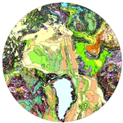
Geological map of the Arctic, 1:5 000 000
Simple
- Date ( RI_367 )
- 2011-02-01
- Date ( RI_366 )
- 2011-02-01
- Edition
- 2159A
- Presentation form
- mapDigital;carteNumérique RI_391
- Name
- A-Series Map
- Issue identification
- 2159A
- Other citation details
- Harrison, J C; St-Onge, M R; Petrov, O V; Strelnikov, S I; Lopatin, B G; Wilson, F H; Tella, S; Paul, D; Lynds, T; Shokalsky, S P; Hults, C K; Bergman, S; Jepsen, H F; Solli, A, 2011.Geological map of the Arctic / Carte géologique de l'Arctique. Geological Survey of Canada, "A" Series Map 2159A, 9 sheets; 1 DVD, doi:10.4095/287868
- Purpose
- Identified applications of the map and database include 1) providing a new geological, physiographic, and tectonic compilation and database context for all Precambrian and Phanerozoic map units that can be shown at 1:5 000 000 scale in the Arctic polar region; 2) documenting and understanding the spatial relationships between mineral/energy resources and
- Status
- completed; complété RI_593
- Maintenance and update frequency
- notPlanned; nonPlanifié RI_542
- GSC Keywords Vocabulary - Thesaurus Thésaurus - vocabulaire de mots-clé de la CGC ( RI_528 )
-
- geology
- Areal geology, maps and charts
- Bedrock Geology
- earth sciences
- NRCan - GSC - Place - Keywords list Liste de mots-clés - RNCan - CGC - Lieu ( RI_528 )
-
- Arctic
- Government of Canada Core Subject Thesaurus Thésaurus des sujets de base du gouvernement du Canada ( RI_528 )
-
- Geology
- Geological maps
- Use limitation
- No constraint
- Use limitation
- Open Government Licence - Canada (http://open.canada.ca/en/open-government-licence-canada)
- Access constraints
- license; licence RI_606
- Use constraints
- otherRestrictions; autresRestrictions RI_609
- Spatial representation type
- vector; vecteur RI_635
- Denominator
- 5000000
- Metadata language
- eng; CAN
- Character set
- utf8; utf8 RI_458
- Topic category
-
- Geoscientific information
- Environment description
- ArcGIS
))
- Begin date
- 2006-01-31
- End date
- 2011-01-31
- Reference system identifier
- http://www.epsg-registry.org/ / EPSG:3995 / 6.14
- Distribution format
-
-
FGDB/GDB
(
unknown
)
-
FGDB/GDB
(
unknown
)
voice; 1 (800) 6612638
- Transfer size
- 1091
- OnLine resource
-
Geological map of the Arctic, 1:5 000 000 - French
(
HTTPS
)
Dataset;HTML;fra
- OnLine resource
-
Carte géologique de l'Arctique, 1:5 000 000 - Anglais
(
HTTPS
)
Dataset;HTML;eng
- OnLine resource
-
Geological map of the Arctic, 1:5 000 000 - English
(
HTTPS
)
Dataset;HTML;eng
- OnLine resource
-
Geological map of the Arctic, 1:5 000 000 - French
(
HTTPS
)
Dataset;HTML;fra
- OnLine resource
-
Geological map of the Arctic, 1:5 000 000 - ESRI REST Service - English
(
ESRI REST: Map Service
)
Web Service;ESRI REST;eng
- OnLine resource
-
Geological map of the Arctic, 1:5 000 000 - ESRI REST Service - French
(
ESRI REST: Map Service
)
Web Service;ESRI REST;fra
- OnLine resource
-
Geological map of the Arctic, 1:5 000 000 - WMS Service - English
(
HTTPS
)
Dataset;WMS;eng
- OnLine resource
-
Geological map of the Arctic, 1:5 000 000 - WMS Service - French
(
HTTPS
)
Dataset;WMS;fra
- OnLine resource
-
Geological map of the Arctic, 1:5 000 000 - dataset - English
(
HTTPS
)
Dataset;FGDB/GDB;eng
- OnLine resource
-
Geological map of the Arctic, 1:5 000 000 - dataset - French
(
HTTPS
)
Dataset;FGDB/GDB;fra
- OnLine resource
-
Geological map of the Arctic, 1:5 000 000 - MXD file ArcMap - French
(
HTTPS
)
Supporting Document;MXD;fra
- OnLine resource
-
Geological map of the Arctic, 1:5 000 000 - MXD file ArcMap - English
(
HTTPS
)
Supporting Document;MXD;eng
- Hierarchy level
- dataset; jeuDonnées RI_622
- Description
-
Title: Dataset creation -- Description: Development of the Geological map of the Arctic and its related database was led by a Geological Survey of Canada (GSC) team based in Ottawa and Calgary, with the active participation of scientific and technical staff from the geological surveys of Russia, the United States, Norway, Sweden, and Denmark. Project work began in February 2006, and a draft version of the map was presented at the 2008 International Geological Congress (IGC) in Oslo, Norway. A preliminary version of the map was then published as GSC Open File 5816 in November 2008. Updates, revisions, and finalization of the digital files underlying the geological map were completed during 2009-10,
leading to the release of the final paper and digital versions on February 1, 2011.
There were many challenges in undertaking a map compilation of this magnitude both technically and geologically. It was important for the compilers to analyze the implications of variables such as map scale, level of attribution, data formatting, classification schemes, and map coverage to implement a coherent and uniform approach to the project. Examples of some of these challenges are given below, with specific details and the rationale for how the polar map compilation was achieved presented in sections 2 to 5.
Some of the technical challenges included the conversion of numerous paper regional maps to digital data, and converting existing diverse digital products to a common database standard. Building a custom topographic base map was necessary to resolve issues of proper registration of geology to shorelines, ice caps, and bathymetric contours. Hundreds of source maps had to be simplified from a wide variety of source scales. Authors were required to create and manage lists of published and unpublished source materials, and credit the more than 50 minor and major project participants.
Map coverage for the extent of the polar region was fairly complete, although some unmapped areas within Canada and offshore required some additional interpolative tools including geophysics, Landsat imagery, and bathymetry to complete the data.
The geological challenges faced were as diverse as agreeing to what constitutes a geology map, what to show, how to show it, and how to build the database. Geologists from some countries needed convincing that rock types could be displayed at 1:5 000 000 scale; others insisted on including surficial (sand, gravel, clay) materials. Agreement on several other features had to be found, including the use of standard terms for geological time periods, definition of map units in the deep ocean basins where Quaternary cover is widespread on the seafloor, and the importance of plate tectonic features. Interpretive inconsistencies along map boundaries (between and within countries) had to be resolved. For the geology of the Russian Arctic, the challenge was to augment the compositional description of supracrustal and lower grade metamorphic units, normally identified by age range only on the smallest scale maps.
A particularly challenging aspect to compiling a map of this scale and extent was to develop a method and rationale for the reclassification of thousands of geological units. A normalized numeric coding scheme was developed to reclassify and generalize the highly variable source-map features while maintaining as much original attribute detail as possible. A second goal was to add new interpretations and attribution at the circumpolar scale through building and querying the spatial distribution of geological features within the database.
Producing a meaningful legend proved to be another challenge due to fundamental differences in the source data and representation of Phanerozoic and Precambrian geology. This led to the design of two different but complementary legends and global-correlation charts. Precambrian units were classified by tectonic domain, providing a basis for correlation of map units within a global tectonic context with alphanumeric map labels emphasizing individual compositional settings and numbered in terms of global relative maximum age from oldest to youngest. Phanerozoic units were grouped by geographic region, providing a basis for documenting the correlation of map units through geological time with each alphanumeric map label implying a unique age and setting with selected compositional variation expressed by a pattern overlay on top of colour.
Collaboration and communication among international contributing authors was complex, given language differences, geographic distance, and at times, transient conflicting scientific interpretations. Ultimately, with patience and compromise, consensus was achieved with the final circumpolar map and database product.
The map compilation database was created using ESRI® ArcGIS® Desktop version 9.3.1. The main geological spatial database is provided in ESRI file geodatabase format, and accompanying layer and style files and fonts are provided for visualization of geological feature classes within ArcMapTM and ArcReaderTM software.
The ArcMap project file (.mxd) and file geodatabase were created under version 9.3.1 and are not backwards compatible with older versions of the software.
ESRI ArcReader software and published map format (.pmf) files are provided to allow users without access to ArcGIS software to view and identify feature attributes within the map database.
All feature classes within the file geodatabase have been exported as shapefiles (.shp) for use with other geographic information system (GIS) software.
Other supplementary files in this release include .pdf versions of the published paper map, legend, and correlation charts (5 sheets).
- Date / Time
- 2011-02-01T00:00:00
- Description
- Multiple sources, data from the geological surveys of Canada, Russia, the United States, Norway, Sweden, and Denmark
- File identifier
- 9f4aacbb-42eb-be93-f0a0-9a30cf6d658f XML
- Metadata language
- eng; CAN
- Character set
- utf8; utf8 RI_458
- Hierarchy level
- dataset; jeuDonnées RI_622
- Date stamp
- 2024-12-11T14:45:29
- Metadata standard name
- North American Profile of ISO 19115:2003 - Geographic information - Metadata
- Metadata standard version
- CAN/CGSB-171.100-2009
- Dataset URI
- https://doi.org/10.4095/287868
Overviews
Spatial extent
Provided by
