 Arctic SDI catalogue
Northern East Greenland’s research history and place names
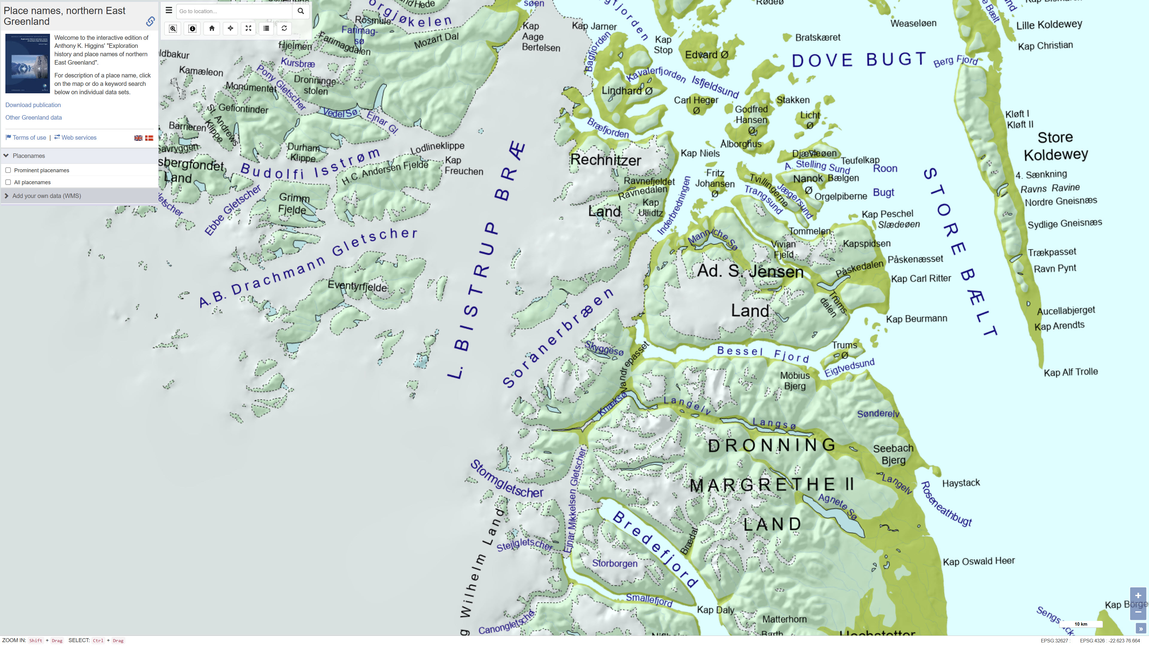
The dataset contains place names and associated historical and explanatory information for Northern East Greenland based on the book Northern East Greenland’s research history and place names by A.K. Higgins, published by GEUS in 2010. The dataset includes geographic locations of place names together with their explanations and historical background.
The original maps and place name information have been converted to a web-based GIS format, allowing users to search for place names via free-text search and view their spatial distribution on an interactive map. The dataset forms part of the web-based presentation of Northern East Greenland’s place names and research history.
Simple
- Date ( Publication )
- 2012-11-26
- Identifier
- dk.geus / grl_place_names_northeast_greenland_higgins
- Presentation form
- Digital map
- Purpose
- The purpose of the dataset is to provide digital access to place names and their historical explanations for Northern East Greenland, supporting research, education and dissemination of geographical and cultural-historical knowledge.
- Status
- Completed
- Maintenance and update frequency
- As needed
- Keywords ( Theme )
-
- Dataset
- Place names
- Northeast Greenland
- Cultural history
- Geographical names
- Database
- Forskningsemner Forskningsemner ( Theme )
- Geografisk Geografisk ( Place )
- Access constraints
- Other restrictions
- Use constraints
- Other restrictions
- Other constraints
- CC BY 4.0
- Other constraints
- The dataset is based on a published source and should be used with proper attribution. Interpretations and descriptions reflect the content of the source publication.
- Spatial representation type
- Vector
- Denominator
- 100000
- Metadata language
- en
- Character set
- UTF8
- Topic category
-
- Geoscientific information
- Location
))
- Supplemental Information
- The dataset was developed as part of the dissemination of place names and research history of Northern East Greenland and forms part of GEUS’ web-based map services.
- Reference system identifier
- WGS 84 / UTM 24N (EPSG:32624)
- Distribution format
-
-
WMS
(
)
-
WFS
(
)
-
SHP
(
)
-
GeoJSON
(
)
-
WMS
(
)
- OnLine resource
-
Interactive webmap
(
WWW:LINK-1.0-http--link
)
Interactive map displaying the dataset.
- OnLine resource
-
Exploration history and place names of northern East Greenland
(
WWW:LINK-1.0-http--link
)
Higgins, A.K. (2010): Northern East Greenland’s research history and place names. Geological Survey of Denmark and Greenland.
GEUS (2012): Launch of web-based interactive map of Northern East Greenland’s place names.
- OnLine resource
-
Place names in northern East Greenland
(
WWW:LINK-1.0-http--link
)
Catalogue of place names in northern East Greenland
- OnLine resource
-
Exploration history and place names of northern East Greenland
GEUS Bulletin Vol. 21: Exploration history and place names of northern East Greenland
- OnLine resource
-
grl_ne_higgins_placenames
(
OGC:WMS-1.3.0-http-get-capabilities
)
WMS for NE Greenland Higgins Placenames
- OnLine resource
-
ms:grl_ne_higgins_placenames
(
OGC:WFS-1.0.0-http-get-capabilities
)
WFS for NE Greenland Higgins Placenames
- OnLine resource
-
Download
Download dataset as shapefile
- OnLine resource
-
Download
Download dataset as GeoJSON
- Hierarchy level
- Dataset
- Statement
-
The dataset is derived from the publication Northern East Greenland’s research history and place names by A.K. Higgins, published by GEUS in 2010. The original place name information and associated maps were compiled as part of historical and geographical research and published in printed form.
For the present dataset, the place name information and maps have been digitised and converted to a web-based GIS format. Geographic locations of place names have been captured and linked to descriptive and historical information from the original publication. The dataset reflects the content and interpretations presented in the source publication.
- File identifier
- a1e6adf9-009f-4ae5-bb83-c10a2ee465da XML
- Metadata language
- Danskda
- Character set
- UTF8
- Hierarchy level
- Dataset
- Date stamp
- 2026-03-02T12:10:06.303243Z
- Metadata standard name
- ISO 19115:2003/19139
- Metadata standard version
- 1.0
Overviews
Spatial extent
Provided by
