 Arctic SDI catalogue
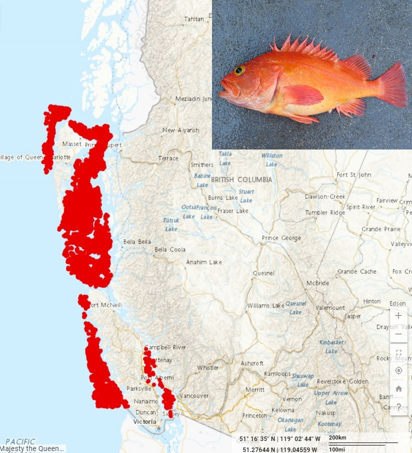
Groundfish Synoptic Bottom Trawl Surveys
Catch, effort, location (latitude, longitude), relative abundance indices, and associated biological data from groundfish multi-species bottom trawl surveys in Queen Charlotte Sound (QCS), Hecate Strait (HS), West Coast Vancouver Island (WCVI), West Coast Haida Gwaii (WCHG) and the Strait of Georgia (SOG), British Columbia.
Introduction
This is a set of long-term and coordinated surveys that together cover the continental shelf and upper slope of most of the British Columbia coast. The objectives of these surveys are to provide fishery-independent abundance indices of all demersal fish species available to bottom trawling and to collect biological samples of selected species. The surveys follow a random depth-stratified design and the sampling units are 2 km by 2 km blocks.
The synoptic bottom trawl surveys are conducted by Fisheries and Oceans Canada (DFO) in collaboration with the Canadian Groundfish Research and Conservation Society (CGRCS), a non-profit society composed of participants in the British Columbia commercial groundfish trawl fishery. The Queen Charlotte Sound and West Coast Haida Gwaii surveys are conducted under collaborative agreements, with the CGRCS providing chartered commercial fishing vessels and field technicians, while DFO provides in-kind contributions for running the surveys including personnel and equipment. The Hecate Strait, West Coast Vancouver Island, and Strait of Georgia surveys are conducted by DFO and have typically taken place on the Canadian Coast Guard research vessel W.E. Ricker. In years when the W.E. Ricker has not been available, the Hecate Strait and West Coast Vancouver Island surveys have taken place on chartered industry vessels.
Simple
- Date ( RI_366 )
- 2018-01-25
- Date ( RI_368 )
- 2020-06-03
- Date ( RI_367 )
- 2018-07-13
- Date ( RI_368 )
- 2022-11-15
- Date ( RI_368 )
- 2023-08-23
- Status
- onGoing; enContinue RI_596
- Maintenance and update frequency
- annually; annuel RI_539
- Keywords ( RI_525 )
-
- Pacific Ocean
- North Pacific
- British Columbia
- Queen Charlotte Sound
- Keywords ( RI_528 )
-
- Bottom Trawl
- Groundfish
- Fishery Independent Data
- Relative Abundance
- Relative Biomass
- Canadian Groundfish Research and Conservation Society
- CGRCS
- Collaborative Agreement
- Commercial Species
- Stock Assessment
- Government of Canada Core Subject Thesaurus Thésaurus des sujets de base du gouvernement du Canada ( RI_528 )
-
- Fisheries
- Oceans
- Resources management
- Marine biology
- Fish
- Surveys
- Classification
- unclassified; nonClassifié RI_484
- Use limitation
- Open Government Licence - Canada (http://open.canada.ca/en/open-government-licence-canada)
- Access constraints
- license; licence RI_606
- Use constraints
- license; licence RI_606
- Spatial representation type
- textTable; texteTable RI_637
- Metadata language
- eng
- Character set
- utf8; utf8 RI_458
- Topic category
-
- Biota
- Oceans
- Begin date
- 2003-01-01
- End date
- 2021-12-31
))
- Reference system identifier
- https://epsg.io / EPSG:4326 /
- Distribution format
-
-
CSV
(
1
)
-
HTML
(
1
)
-
CSV
(
1
)
- OnLine resource
-
Reference Information - Synoptic Bottom Trawl Surveys
(
HTTPS
)
Supporting Document;HTML;eng,fra
- OnLine resource
-
Strait of Georgia Synoptic Bottom Trawl Survey
(
HTTPS
)
Supporting Document;HTML;eng,fra
- OnLine resource
-
Hecate Strait Synoptic Bottom Trawl Survey
(
HTTPS
)
Supporting Document;HTML;eng,fra
- OnLine resource
-
Queen Charlotte Sound Synoptic Bottom Trawl Survey
(
HTTPS
)
Supporting Document;HTML;eng,fra
- OnLine resource
-
West Coast Vancouver Island Synoptic Bottom Trawl Survey
(
HTTPS
)
Supporting Document;HTML;eng,fra
- OnLine resource
-
West Coast Haida Gwaii Synoptic Bottom Trawl Survey
(
HTTPS
)
Supporting Document;HTML;eng,fra
- OnLine resource
-
Data Dictionary
(
HTTPS
)
Supporting Document;XLSX;eng,fra
- File identifier
- a278d1af-d567-4964-a109-ae1e84cbd24a XML
- Metadata language
- eng; CAN
- Character set
- utf8; utf8 RI_458
- Hierarchy level
- series; série RI_623
- Date stamp
- 2026-07-07T15:51:23.481585Z
- Metadata standard name
- North American Profile of ISO 19115:2003 - Geographic information - Metadata
- Metadata standard version
- CAN/CGSB-171.100-2009
Overviews
Spatial extent
Provided by
