 Arctic SDI catalogue
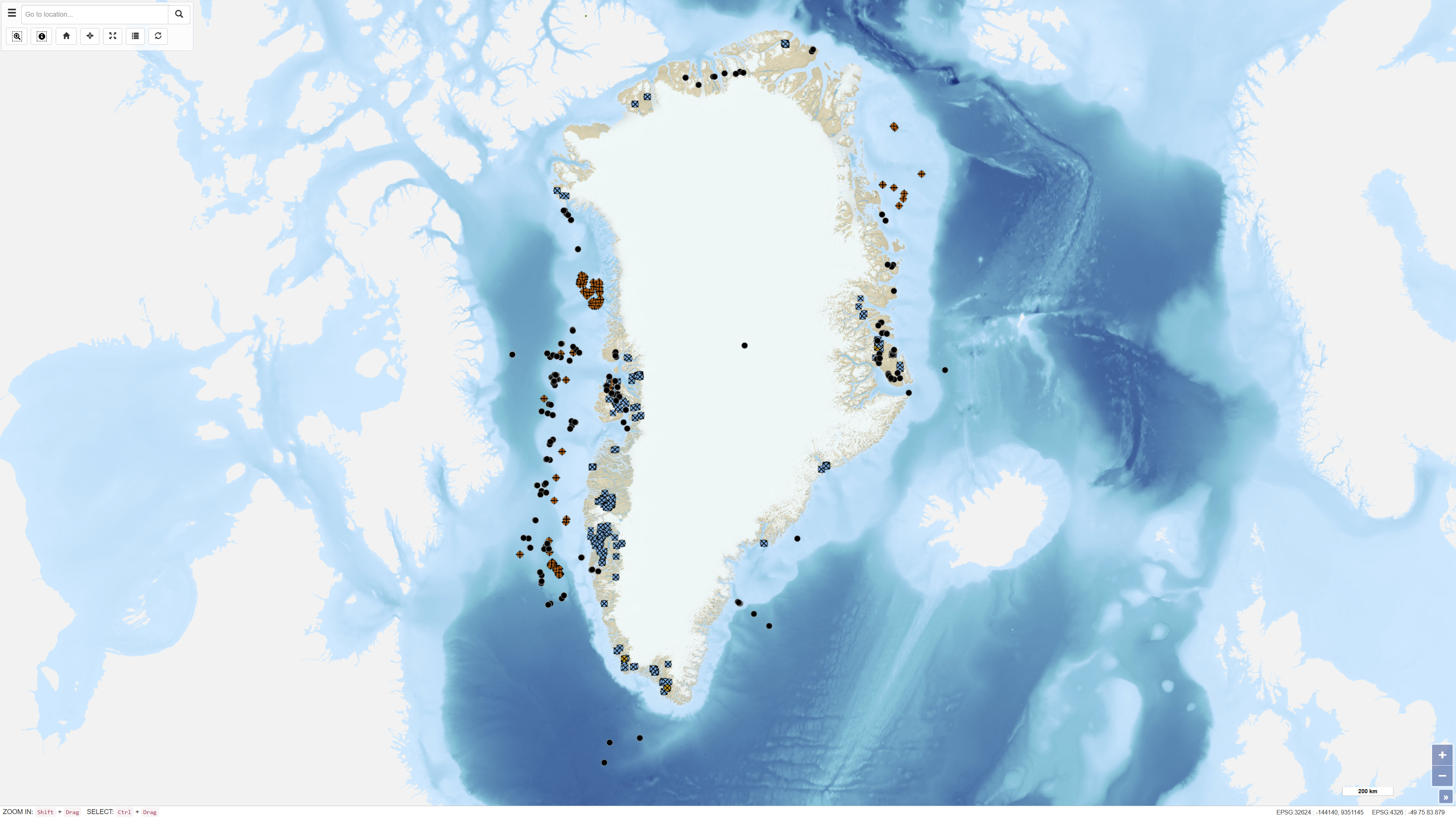
Boreholes in Greenland
Simple
- Date ( Publication )
- 2022-01-01
- Identifier
- dk.geus / grl_drillholes_locations
- Presentation form
- Digital map
- Purpose
- The purpose of the dataset is to provide a consolidated geographic overview of drillholes in Greenland and to support data discovery, documentation and planning related to geological research and resource exploration.
- Status
- On going
- Maintenance and update frequency
- As needed
- Keywords ( Theme )
-
- Dataset
- Boreholes
- Mineral Exploration
- Oil and Gas Exploration
- Greenland
- Database
- Forskningsemner Forskningsemner ( Theme )
- Geografisk Geografisk ( Place )
- Access constraints
- Other restrictions
- Use constraints
- Other restrictions
- Other constraints
- CC BY 4.0
- Other constraints
- The dataset is a reference dataset compiled from existing registrations in the GREENCORE and SAMBA databases. It does not contain complete borehole logs or primary measurement data. Users must ensure appropriate citation when using the dataset and consult the original sources for detailed technical information. GEUS assumes no liability for interpretations or decisions based on the dataset.
- Spatial representation type
- Vector
- Denominator
- 500000
- Metadata language
- en
- Character set
- UTF8
- Topic category
-
- Geoscientific information
- Begin date
- 1948-01-01
))
- Supplemental Information
- The dataset functions as an index and reference dataset representing generalised drillhole locations. Coordinates and associated information may vary in precision depending on the original source. The dataset does not constitute a legal definition or detailed technical documentation of individual drillholes. For detailed information on drilling operations, core descriptions or technical data, the original sources must be consulted.
- Reference system identifier
- WGS 84 / UTM 24N (EPSG:32624)
- Distribution format
-
-
WMS
(
)
-
WFS
(
)
-
SHP
(
)
-
GeoJSON
(
)
-
WMS
(
)
- OnLine resource
-
Download
Download dataset as shapefile
- OnLine resource
-
Interactive webmap
(
WWW:LINK-1.0-http--link
)
Interactive map displaying the dataset.
- OnLine resource
-
totalcore
(
OGC:WMS-1.3.0-http-get-capabilities
)
WMS for Drillhole localities
- OnLine resource
-
Inspection of drill cores
(
WWW:LINK-1.0-http--link
)
GEUS offers the possibility to inspect cores from deep wells at our corestore equipped with display facilities.
- OnLine resource
-
Grønlands undergrunds- og sivningsdata
(
WWW:LINK-1.0-http--link
)
Here you can find information about boreholes, geophysical surveys and geochemical studies related to petroleum exploration and associated activities in Greenland
- OnLine resource
-
ms:totalcore
(
OGC:WFS-1.0.0-http-get-capabilities
)
WFS for Drillhole localities
- OnLine resource
-
Download
Download dataset as GeoJSON
- Hierarchy level
- Dataset
- Statement
- The dataset was established through the integration of two primary data sources. The first source is the GREENCORE database, previously used for registration of mineral exploration drill cores stored at the former Bureau of Minerals and Petroleum drill core facilities in Greenland, now under the Government of Greenland (MMR). The second source consists of Greenlandic boreholes from the SAMBA database, including hydrocarbon exploration wells and other drill cores stored at the GEUS core repository in Copenhagen. The dataset represents a compilation of existing registrations and does not contain primary drilling data or complete borehole logs.
- File identifier
- aa58e8d0-8c2c-4e71-af8f-f52dbb856f2c XML
- Metadata language
- Danskda
- Character set
- UTF8
- Hierarchy level
- Dataset
- Date stamp
- 2026-03-19T14:16:38.273519Z
- Metadata standard name
- ISO 19115:2003/19139
- Metadata standard version
- 1.0
Overviews
Spatial extent
Provided by
