 Arctic SDI catalogue
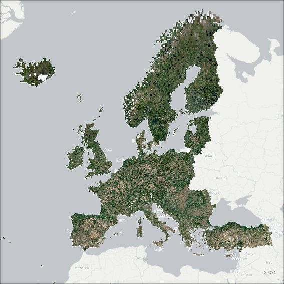
Pan-European Very High Resolution Image Mosaic 2021 - True Colour (2 m), July 2024
The pan-European Very High Resolution (VHR) Image Mosaic 2021 is a seamless mosaic of the VHR 2021 dataset.
The input data consists of a mix of Pleiades, SuperView, Worldview, Kompsat-3, Kompsat-4, Geoeye, SPOT, Deimos-2, Vision-1 and TripleSat images. To enhance the appearance of the input imagery, a histogram stretch was applied, cutting off the lowest and highest 0.1 percent of the histogram values and stretching the remaining values to fit the 16-bit pixel depth. For each input image, only selected areas were used to create the mosaic, and the rest was masked out to exclude areas with clouds and their shadows. Color balance was achieved using a second-order method, which modifies all input pixels toward a set of multiple points derived from a two-dimensional polynomial parabolic surface, ensuring a seamless mosaic.
For several water bodies, especially large lakes, the final result exhibited a patchy surface pattern due to presence of sun glint on the satellite images. A post-processing methodology was implemented to recalculate the digital values to produce a seamless appearance surface of some of these major lakes: Vänern and Vättern (Sweden), Oulu (Finland), Peipus (Estonia), Geneva (Switzerland/France), Constance (Switzerland/Germany/Austria), Garda and Bolsena (Italy), Skadar (Montenegro/Albania), Prespa (North Macedonia/Albania/Greece), Beysehir, Iznik and Van (Turkey). The applied methodology consisted of creating individual mosaics with the images comprising only the mentioned lakes (a mosaic per lake), calculating Normalized Difference Vegetation Index (NDVI) for shoreline extraction, and color balancing each mosaic individually with all land surfaces masked out, using only pixels belonging to the water category. This approach allowed smoothing the patchy surfaces of the above-mentioned lakes considering statistics solely from the water pixels, ensuring a more uniform appearance.
To enhance the visualization of the entire dataset at larger scales (greater than 1:500.000), the mosaic displays pan-European overviews generated from the pan-European Very High Resolution 2018 Image Mosaic. The updated VHR 2021 version is visualized only at scales below 1:500.000.
The mosaic primarily is used as input data in the production of various Copernicus Land Monitoring Service (CLMS) datasets and services, such as land cover maps and high-resolution layers on land cover characteristic. It can be also useful for CLMS users for visualizations and classifications on land.
The input imagery for the creation of the mosaic is provided by ESA. Due to license restrictions, the VHR Image Mosaic 2021 is only available as a web map service (WMS), and not for data download.
Simple
- Date ( Creation )
- 2024-01-01T00:00:00
- Date ( Publication )
- 2024-07-31T00:00:00
- Edition
- 01.00
- Identifier
- copernicus_r_3035_2_m_vhrim-tc-2021_i_2020-2022_v01_r00
- Maintenance and update frequency
- As needed
- GEMET - INSPIRE themes, version 1.0 ( Theme )
- Keywords
-
- Keywords
-
- GEMET ( Theme )
- Continents, countries, sea regions of the world. ( Place )
-
- United Kingdom
- EEA38 (from 2020)
- Spatial scope ( Theme )
- Temporal resolution ( Temporal )
-
- As needed
- EEA topics ( Theme )
- Access constraints
- Other restrictions
- Other constraints
- no limitations to public access
- Use constraints
- Other restrictions
- Other constraints
-
The Copernicus component is governed by Regulation (EU) No 2021/696 of the European Parliament and of the Council of 28 April 2021 establishing the Union Space Programme and the European Union Agency for the Space Programme and repealing Regulations (EU) No 912/2010, (EU) No 1285/2013 and (EU) No 377/2014 and Decision No 541/2014/EU. Within the Copernicus component, a portfolio of land monitoring activities has been delegated by the European Union to the European Environment Agency (EEA) and the DG Joint Research Centre of the European Commission.
The Copernicus land monitoring products and services are made available on a principle of full, open and free access, as established by the Commission Delegated Regulation (EU) No 1159/2013 of 12 July 2013.
Free, full and open access to the products and services of the Copernicus Land Monitoring Service is made on the conditions that:
1. When distributing or communicating Copernicus Land Monitoring Service products and services (data, software scripts, web services, user and methodological documentation and similar) to the public, users shall inform the public of the source of these products and services.
2. Where the Copernicus Land Monitoring Service products and services have been adapted or modified by the user, the user shall clearly state this.
3. Users shall make sure not to convey the impression to the public that the user's activities are officially endorsed by the European Union.
- Spatial representation type
- grid Grid
- Distance
- 2 m
- Metadata language
- en
- Topic category
-
- Environment
- Imagery base maps earth cover
))
- Begin date
- 2020-05-01
- End date
- 2022-09-30
- Unique resource identifier
- EPSG:3035
- Distribution format
-
-
GeoTIFF
(
)
-
GeoTIFF
(
)
- OnLine resource
- https://copernicus.discomap.eea.europa.eu/arcgis/services/GioLand/VHR_2021_LAEA/ImageServer/WMSServer?request=GetCapabilities&service=WMS ( OGC:WMS )
- OnLine resource
- https://copernicus.discomap.eea.europa.eu/arcgis/rest/services/GioLand/VHR_2021_LAEA/ImageServer ( ESRI:REST )
- OnLine resource
- Product Information & Technical Documentation ( WWW:LINK )
OnLine resource
- Hierarchy level
- Dataset
Conformance result
- Date ( Publication )
- 2010-12-08
- Explanation
- See the referenced specification
- Statement
-
The input data consists of a mix of Pleiades, SuperView, Worldview, Kompsat-3, Kompsat-4, Geoeye, SPOT, Deimos-2, Vision-1 and TripleSat images.
The processing steps were as follows:
1. Preprocessing of all data by calculating statistics and merging large tiled products into single frames.
2. Creating the mosaic dataset, including a histogram stretch of each image, removing the 0.1 percentage of low and high values of the histogram, and stretching new values to 16 bits.
3. Importing the footprint of pre-defined selected areas to be used in the mosaic.
4. Calculating the full mosaic statistics.
5. Color balancing.
6. Post-processing to correct patchy surface on 12 major lakes: creation of individual mosaic for each lake, NDVI calculation for shoreline delineation, statistics calculation and color balancing.
The steps outlined above were implemented using custom Python/arcpy code.
- File identifier
- ac127b0b-8087-4889-8f99-cab372cfc0fc XML
- Metadata language
- en
- Character set
- UTF8
- Hierarchy level
- Dataset
- Date stamp
- 2026-04-20T13:33:39.379658Z
- Metadata standard name
- ISO 19115/19139
- Metadata standard version
- 1.0
Overviews
Spatial extent
Provided by
