 Arctic SDI catalogue
Canadian Hydrospatial Network - CHN
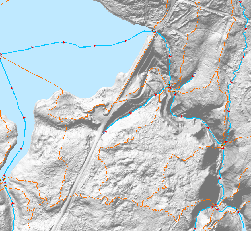
The Canadian Hydrospatial Network (CHN) is an analysis-ready geospatial network of features that help enable the modelling of surface water flow in Canada. The six main layers and feature types are: flowlines, waterbodies, catchments, catchment aggregates, work units, and hydro nodes.
Where possible the CHN is derived from high resolution source data such as Light Detection and Ranging (LiDAR) derived Digital Elevation Models (DEMs) and aerial imagery, to name a few. If existing provincial or territorial hydrographic networks meet the standards, they are incorporated into the CHN, otherwise automatic extraction methods are used on the high-resolution source data. To provide full network connectivity, if neither of these methods is possible in a region, the NHN is converted into the CHN until higher-resolution source data is available.
Additional value-added attributes are included in the CHN to aid modelling, such as stream order and reach slope. The CHN physical model and features are also closely aligned and harmonized with the USGS 3DHP hydrographic network, which aids trans-border modelling. Where possible geonames (i.e. toponyms) are also added.
The CHN is produced and disseminated by hydrologically connected geographic areas called work units. Work units can contain just one watershed, several small adjacent watersheds outletting into a large body of water, or be one of many parts of a larger watershed. In all cases, the features of a work unit are hydrologically connected. This is a more natural approach to data delivery, in comparison to data that is split into tiles. A generalized work unit index file is provided in the downloads to help users decide which files to download.
For more information on the CHN please visit the project webpage:
https://natural-resources.canada.ca/canadian-hydrospatial-network
Simple
- Date ( RI_366 )
- 2024-02-15T12:30:00
- Date ( RI_367 )
- 2024-02-22T12:30:00
- Status
- onGoing; enContinue RI_596
- Maintenance and update frequency
- asNeeded; auBesoin RI_540
- Keywords
-
- CHN
- Hydrospatial
- Geospatial
- GeoBase
- Hydrographic Network
- RHC
- Government of Canada Core Subject Thesaurus Thésaurus des sujets de base du gouvernement du Canada ( RI_528 )
-
- Rivers
- Surface water
- Water
- Networks
- Hydrology
- Hydrography
- Watercourses
- Watersheds
- Streams
- Lakes
- Geography
- Natural resources
- Earth sciences
- Geographic data
- Use limitation
- Open Government Licence - Canada (http://open.canada.ca/en/open-government-licence-canada)
- Access constraints
- license; licence RI_606
- Use constraints
- license; licence RI_606
- Spatial representation type
- vector; vecteur RI_635
- Metadata language
- eng
- Metadata language
- fre
- Topic category
-
- Geoscientific information
- Inland waters
))
- Begin date
- 2024-02-15
- Reference system identifier
- https://www.epsg-registry.org / EPSG:4617 / unknown
- Distribution format
-
-
GPKG
(
unknown
)
-
WMS
(
unknown
)
-
GPKG
(
unknown
)
- OnLine resource
-
Web Service (english) - CHN - Canadian Hydrospatial Network
(
ESRI REST: Map Server
)
Web Service;ESRI REST;eng
- OnLine resource
-
Web Service (french) - CHN - Canadian Hydrospatial Network
(
ESRI REST: Map Server
)
Web Service;ESRI REST;fra
- OnLine resource
-
Vector Datasets (bilingual) - CHN - Canadian Hydrospatial Network
(
FTP
)
Dataset;GPKG;eng,fra
- OnLine resource
-
Documentation (english and french) - CHN - Canadian Hydrospatial Network
(
FTP
)
Supporting Document;PDF;eng,fra
- OnLine resource
-
CHN Index of Available Files (English) - work unit boundaries and grades
(
HTTPS
)
Web Service;ESRI REST;eng
- OnLine resource
-
CHN Index of Available Files (French) - work unit boundaries and grades
(
HTTPS
)
Web Service;ESRI REST;fra
- File identifier
- ae385105-e48c-4b54-bd0f-dfb7303301cb XML
- Metadata language
- eng; CAN
- Character set
- utf8; utf8 RI_458
- Hierarchy level
- dataset; jeuDonnées RI_622
- Date stamp
- 2024-12-30T09:23:59
- Metadata standard name
- North American Profile of ISO 19115:2003 - Geographic information - Metadata
- Metadata standard version
- CAN/CGSB-171.100-2009
Overviews
Spatial extent
Provided by
