 Arctic SDI catalogue
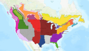
Crop Field Trial Regions
The Canadian major and minor crop field trial regions were developed following extensive stakeholder consultation and have been harmonized between the Pest Management Regulatory Agency (PMRA) and the Environmental Protection Agency of the USA.
The Canadian major and minor crop field trial regions were delineated, using the geographic
information system (GIS) data processing hardware and software facilities in Spatial Analysis
and Geomatics Applications (SAGA), Agriculture Division, Statistics Canada. In general, the
delineation process involved integration, evaluation and reference to numerous geographic data sources in a GIS to determine the best sources for the delineation.
There are seven major and four minor field trial regions. Each of these regions recognizes physical characteristics, such as soils, and crops and climate, that make the region unique within the Canadian agricultural landscape. The subzones address differences within a region, generally reflected in the types of crops grown in that region. The Canadian regions, as much as possible, correspond to the U.S. regions
Simple
- Date ( RI_366 )
- 2019-07-03
- Date ( RI_367 )
- 1998-06-01
- Presentation form
- mapDigital;carteNumérique RI_391
- Status
- completed; complété RI_593
- Maintenance and update frequency
- asNeeded; auBesoin RI_540
- Keywords ( RI_528 )
-
- Boundaries
- pest management
- crop
- Government of Canada Core Subject Thesaurus Thésaurus des sujets de base du gouvernement du Canada ( RI_528 )
-
- Boundaries
- Pesticides
- Use limitation
- Open Government Licence - Canada (http://open.canada.ca/en/open-government-licence-canada)
- Use limitation
- Open Government Licence - Canada (http://open.canada.ca/en/open-government-licence-canada)
- Access constraints
- license; licence RI_606
- Use constraints
- license; licence RI_606
- Spatial representation type
- vector; vecteur RI_635
- Metadata language
- eng; CAN
- Topic category
-
- Boundaries
- Begin date
- 2019-07-03
))
- Reference system identifier
- http://www.epsg-registry.org/ / EPSG:3857 / 8.1.4
- OnLine resource
-
Data Product Specification (English)
(
HTTPS
)
Supporting Document;PDF;eng
- OnLine resource
-
Data Product Specification (French)
(
HTTPS
)
Supporting Document;PDF;fra
- OnLine resource
-
Pre-packaged FGDB files
(
HTTPS
)
Dataset;FGDB/GDB;eng,fra
- OnLine resource
-
Pre-packaged GeoJSON files
(
HTTPS
)
Dataset;GEOJSON;eng,fra
- OnLine resource
-
Crop Field Trial Regions and Safe Zones (English)
(
HTTPS
)
Application;Web App;eng
- OnLine resource
-
Crop Field Trial Regions and Safe Zones (French)
(
HTTPS
)
Application;Web App;fra
- OnLine resource
-
Canada US Crop Field Trial Regions (AGOL)
(
HTTPS
)
Web Service;ESRI REST;eng,fra
- OnLine resource
-
Canada Crop Field Trial Regions Safe Zones (AGOL)
(
HTTPS
)
Web Service;ESRI REST;eng,fra
- File identifier
- aec30fed-3572-4672-bcd7-7b3efdbe7fae XML
- Metadata language
- eng; CAN
- Character set
- utf8; utf8 RI_458
- Hierarchy level
- series; série RI_623
- Date stamp
- 2025-11-21T15:03:32
- Metadata standard name
- North American Profile of ISO 19115:2003 - Geographic information - Metadata
- Metadata standard version
- CAN/CGSB-171.100-2009
Overviews


Spatial extent
Provided by
