 Arctic SDI catalogue
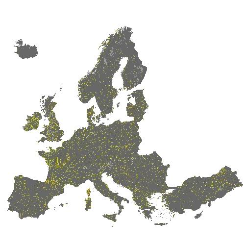
Small Woody Features 2015 (vector), Europe, 3-yearly - Nov. 2019
The HRL Small Woody Features (SWF) is a new Copernicus Land Monitoring Service (CMLS) product, which provides harmonized information on linear structures such as hedgerows, as well as patches (200 m² ≤ area ≤ 5000 m²) of woody features across the EEA39 countries.
Small woody landscape features are important vectors of biodiversity and provide information on fragmentation of habitats with a direct potential for restoration while also providing a link to hazard protection and green infrastructure, amongst others. The SWF layer contains woody linear, and small patchy elements, but is not differentiated into trees, hedges, bushes and scrub. The spatial pattern are limited to linear structures and isolated patches (patchy structures) on the basis of geometric characteristics. Additional Woody Features (AWF) are also included in this product. They consist of woody structures that do not fulfil the SWF geometric specifications but which are connected to valid SWFs structures. VHR imagery (DEIMOS-2, Pleiades 1A, Pleiades 1B, GeoEye-1, SPOT 6, SPOT 7, WorldView-2, WorldView-3 images from 2015) made available in the ESA Copernicus DWH are the main data source for the detection of small woody features identifiable within the given image resolution.
The dataset is available for the 2015 reference year and is produced in three different formats. This metadata corresponds to the SWF vector layer, which separates the SWF class into Linear (code = 1) and Patchy (code = 2). Additional Woody Features are represented with code = 3. This is the primary product of the Small Woody Features mapping, and thus also the one with most detail. The vector data set can be downloaded in Geodatabase and Geopackage formats.
Simple
- Date ( Creation )
- 2019-11-06
- Date ( Publication )
- 2019-11-06
- Date ( Revision )
- 2020-03-04
- Edition
- 01.00
- Identifier
- copernicus_v_3035_5_k_swf-2015_p_2014-2016_v01_r00
- Identifier
- DAT-237-en
- Unique resource identifier
- 10.2909/afde0fbb-6401-45cd-aabd-3aa7b4b3a7f0
- Maintenance and update frequency
- Continual
- GEMET - INSPIRE themes, version 1.0 ( Theme )
-
- Land cover
- Keywords
-
- Continents, countries, sea regions of the world. ( Place )
-
- EEA39
- Keywords
-
- GEMET ( Theme )
-
- landscape alteration
- land use
- sealing
- land cover
- urban area
- soil surface sealing
- built environment
- Spatial scope ( Theme )
- EEA Management Plan ( Theme )
-
- 2020 3.6.7
- EEA topics ( Theme )
-
- Biodiversity
- Agriculture and food
- Land use
- Access constraints
- Other restrictions
- Other constraints
- no limitations to public access
- Use constraints
- Other restrictions
- Other constraints
-
The Copernicus component is governed by Regulation (EU) No 2021/696 of the European Parliament and of the Council of 28 April 2021 establishing the Union Space Programme and the European Union Agency for the Space Programme and repealing Regulations (EU) No 912/2010, (EU) No 1285/2013 and (EU) No 377/2014 and Decision No 541/2014/EU. Within the Copernicus component, a portfolio of land monitoring activities has been delegated by the European Union to the European Environment Agency (EEA) and the DG Joint Research Centre of the European Commission.
The Copernicus land monitoring products and services are made available on a principle of full, open and free access, as established by the Commission Delegated Regulation (EU) No 1159/2013 of 12 July 2013.
Free, full and open access to the products and services of the Copernicus Land Monitoring Service is made on the conditions that:
1. When distributing or communicating Copernicus Land Monitoring Service products and services (data, software scripts, web services, user and methodological documentation and similar) to the public, users shall inform the public of the source of these products and services.
2. Where the Copernicus Land Monitoring Service products and services have been adapted or modified by the user, the user shall clearly state this.
3. Users shall make sure not to convey the impression to the public that the user's activities are officially endorsed by the European Union.
- Spatial representation type
- vector Vector
- Denominator
- 5000
- Metadata language
- en
- Character set
- utf8 UTF8
- Topic category
-
- Environment
- Imagery base maps earth cover
- Begin date
- 2014-01-01
- End date
- 2016-12-31
))
- Unique resource identifier
- EPSG:3035
- Distribution format
-
-
GDB
(
)
-
Geopackage
(
)
-
GDB
(
)
- OnLine resource
-
CLMS Website
(
WWW:DOWNLOAD
)
Download (requires authentication)
- OnLine resource
- https://image.discomap.eea.europa.eu/arcgis/rest/services/DownloadLayers/HRL_SWF_2015_DL/MapServer/ ( ESRI:REST )
- OnLine resource
-
0
(
OGC:WMS
)
SWF_2015_DownloadLayer_WM
- OnLine resource
- https://doi.org/10.2909/afde0fbb-6401-45cd-aabd-3aa7b4b3a7f0 ( DOI )
- OnLine resource
- Product Information & Technical Documentation ( WWW:LINK )
- Hierarchy level
- Dataset
Conformance result
- Date ( Publication )
- 2010-12-08
- Explanation
- See the referenced specification
- Statement
-
Supervised classification and visual interpretation of linear and patchy features on pan-sharpened VHR_IMAGE_2015. Small woody landscape features are important vectors of biodiversity and provide information on fragmentation of habitats with a direct potential for restoration while also providing a link to hazard protection and green infrastructure, amongst others (code = 1). Besides, the Minimum Mapping Unit (MMU) for small patches of trees is 200 m² while the Maximum Mapping Unit (MaxMU) is defined by 5000 m². The Minimum Mapping Length (MML) of linear elements is 50 m. There is also an other distinction between this two structures: width (30 m maximum for linear instead of 30 m minimum for patchy). Additional Woody Features (code = 3) consist of woody structures that do not fulfil the SWF geometric specifications but which are connected to valid SWFs structures, as well as patchy structures too large to be considered as valid SWF. No data (code = 254). Out of Large Region limits (code = 255). Tiles NO116 (Southeast Norway) and NO119 (Northeast Norway) have been discontinued and will not be published due to lack of availability of suitable satellite data.
Some tiles in the dataset are marked as v. 020. These tiles did first show unsatisfactory results and had to be reprocessed.
- File identifier
- afde0fbb-6401-45cd-aabd-3aa7b4b3a7f0 XML
- Metadata language
- en
- Character set
- UTF8
- Hierarchy level
- Dataset
- Date stamp
- 2025-10-09T11:09:08.840503Z
- Metadata standard name
- ISO 19115/19139
- Metadata standard version
- 1.0
Overviews
Spatial extent
Provided by
