 Arctic SDI catalogue
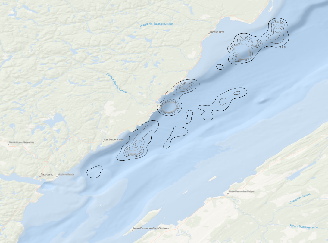
Blue Whale - High density feeding areas
11 tagged Blue whales (Balaenoptera musculus) were tracked during the daytime movements as well as the feeding behaviour in the St. Lawrence River estuary. Kernel density was applied to derminate the high density feeding areas of all individuals combined (30, 40, 50, 60, 75, 95 %).
Doniol-Valcroze T, Lesage V, Giard J, Michaud R, 2012. Challenges in marine mammal habitat modelling: evidence of multiple foraging habitats from the identification of feeding events in blue whales. Endang Species Res, Vol. 17 : 255–268, doi : 10.3354/esr00427
(English version only)
Simple
- Date ( RI_367 )
- 2012
- Date ( RI_366 )
- 2012
https://www.dfo-mpo.gc.ca/oceans/planning-planification/index-fra.html
- Status
- completed; complété RI_593
- Maintenance and update frequency
- asNeeded; auBesoin RI_540
- Keywords ( RI_528 )
-
- Blue Whale
- Thésaurus des sujets de base du gouvernement du Canada Government of Canada Core Subject Thesaurus ( RI_528 )
-
- Environment
- Oceans
- Marine biology
- Use limitation
- Open Government Licence - Canada (http://open.canada.ca/en/open-government-licence-canada)
- Access constraints
- license; licence RI_606
- Use constraints
- license; licence RI_606
- Classification
- unclassified; nonClassifié RI_484
- Spatial representation type
- vector; vecteur RI_635
- Metadata language
- fra; CAN
- Topic category
-
- Environment
- Oceans
- Biota
- Begin date
- 2002
- End date
- 2009
- Description
- St. Lawrence River estuary
))
- Reference system identifier
- https://epsg.io / EPSG:4269 / 9.8(3.0.1)
- Distribution format
-
-
FGDB/GDB
(
Inconnue
)
-
FGDB/GDB
(
Inconnue
)
https://www.dfo-mpo.gc.ca/oceans/planning-planification/index-fra.html
- OnLine resource
-
Blue whale - High density feeding areas (30, 40, 50, 60, 75, 95 %)
(
ESRI REST: Map Service
)
Web Service;ESRI REST;fra
- OnLine resource
-
BlueWhaleHighDensityFeedingAreas.gdb.zip
(
HTTPS
)
Dataset;FGDB/GDB;eng,fra
- OnLine resource
-
Blue whale - High density feeding areas (30, 40, 50, 60, 75, 95 %)
(
ESRI REST: Map Service
)
Web Service;ESRI REST;eng
- File identifier
- b01942e8-d6c6-49ef-9eaa-1cb28e08ce48 XML
- Metadata language
- fra; CAN
- Character set
- utf8; utf8 RI_458
- Hierarchy level
- dataset; jeuDonnées RI_622
- Date stamp
- 2025-02-04T20:02:01.385Z
- Metadata standard name
- North American Profile of ISO 19115:2003 - Geographic information - Metadata
- Metadata standard version
- CAN/CGSB-171.100-2009
https://www.dfo-mpo.gc.ca/oceans/planning-planification/index-fra.html
Overviews
Spatial extent
Provided by
