 Arctic SDI catalogue
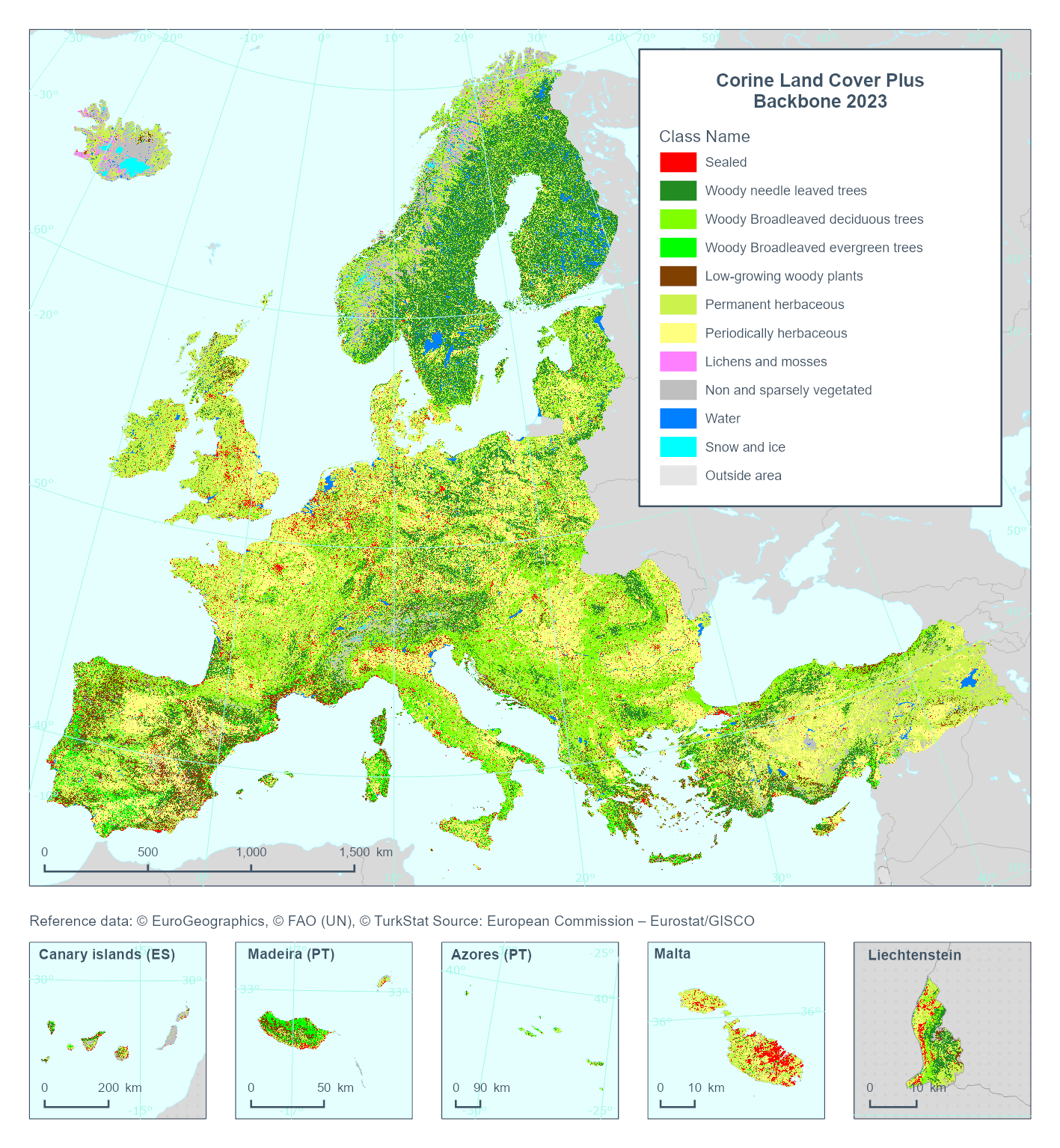
CLCplus Backbone 2023 (raster 10 m), Europe, 2-yearly, May 2025
This metadata refers to the Corine Land Cover plus Backbone (CLCplus Backbone), a spatially detailed, large-scale, Earth Observation-based land cover inventory which is produced by the Copernicus Land Monitoring Service (CLMS). The CLCplus Backbone is a high-resolution raster land cover map based on Sentinel-2 satellite time series. Each 10m-pixel contains the dominant land cover among the 11 basic land cover classes. See pixel class codes in the 'Additional Information' section below.
The product is available from the 2018 reference year, with a first update produced for the 2021 reference year and moved to an update cycle of 2 years from 2021 onwards.
Simple
- Date ( Creation )
- 2025-01-29
- Date ( Publication )
- 2025-04-11
- Edition
- 01.00
- Identifier
- copernicus_r_3035_10_m_clcplus-backbone_p_2023_v01_r00
- Unique resource identifier
- 10.2909/b0bd43c6-1fa1-4d88-9c45-98b13a95d0b2
Point of contact
Point of contact
- Maintenance and update frequency
- As needed
- GEMET - INSPIRE themes, version 1.0 ( Theme )
- Keywords
-
- Continents, countries, sea regions of the world. ( Place )
-
- United Kingdom
- EEA38 (from 2020)
- Keywords
-
- GEMET ( Theme )
- Spatial scope ( Theme )
- EEA topics ( Theme )
- Access constraints
- Other restrictions
- Other constraints
- no limitations to public access
- Use constraints
- Other restrictions
- Other constraints
-
The Copernicus component is governed by Regulation (EU) No 2021/696 of the European Parliament and of the Council of 28 April 2021 establishing the Union Space Programme and the European Union Agency for the Space Programme and repealing Regulations (EU) No 912/2010, (EU) No 1285/2013 and (EU) No 377/2014 and Decision No 541/2014/EU. Within the Copernicus component, a portfolio of land monitoring activities has been delegated by the European Union to the European Environment Agency (EEA) and the DG Joint Research Centre of the European Commission.
The Copernicus land monitoring products and services are made available on a principle of full, open and free access, as established by the Commission Delegated Regulation (EU) No 1159/2013 of 12 July 2013.
Free, full and open access to the products and services of the Copernicus Land Monitoring Service is made on the conditions that:
1. When distributing or communicating Copernicus Land Monitoring Service products and services (data, software scripts, web services, user and methodological documentation and similar) to the public, users shall inform the public of the source of these products and services.
2. Where the Copernicus Land Monitoring Service products and services have been adapted or modified by the user, the user shall clearly state this.
3. Users shall make sure not to convey the impression to the public that the user's activities are officially endorsed by the European Union.
- Spatial representation type
- grid Grid
- Distance
- 10 m
- Metadata language
- en
- Character set
- utf8 UTF8
- Topic category
-
- Environment
- Imagery base maps earth cover
))
- Begin date
- 2022-10-01
- End date
- 2024-03-31
- Supplemental Information
-
Pixel class codes:
1: Sealed
2: Woody needle leaved trees
3: Woody broadleaved deciduous trees
4: Woody broadleaved evergreen trees
5: Low-growing woody plants
6: Permanent herbaceous
7: Periodically herbaceous
8: Lichens and mosses
9: Non and sparsely vegetated
10: Water
11: Snow and ice
253: Coastal seawater buffer
254: Outside area
255: No data
- Unique resource identifier
- EPSG:3035
- Distribution format
-
-
GeoTIFF
(
)
-
GeoTIFF
(
)
- OnLine resource
- Product Information & Technical Documentation ( WWW:LINK-1.0-http--link )
- OnLine resource
-
WEkEO Portal
(
WWW:URL
)
Download (requires authentication)
- OnLine resource
- CLMS_CLCplus_RASTER_2023_010m_eu ( OGC:WMS )
OnLine resource
- OnLine resource
- https://doi.org/10.2909/b0bd43c6-1fa1-4d88-9c45-98b13a95d0b2 ( DOI )
- Hierarchy level
- Dataset
Conformance result
- Date ( Publication )
- 2010-12-08
- Explanation
- See the referenced specification
- Statement
-
CLCplus Backbone Raster Product is primarily based on a supervised classification of satellite image time-series.
Input data:
Copernicus Sentinel-2 imagery (L2A) including all scenes with a cloud cover below 80% and acquired between October 2022 and March 2024.
Training and test data:
Based on the sample data base created for reference year 2018 which was originally compiled from various sources (i.e. adjusted and filtered Eurostat LUCAS 2018 data, stratified automated land cover class annotations based on existing land use/land cover maps, visual sample point photo-interpretation from VHR imagery, NDVI time series and further auxiliary datasets).
Classification:
A Temporal Convolutional Neural Network (TempCNN) with four hierarchical layers was calibrated on the collected training data and input time-series / features. Given the heterogeneity of the addressed European landscapes, all classifier training, testing and, finally, land cover classification, was performed along substrata (i.e. 132 production units) that are based on biogeographical regions and existing land cover layers.
Postprocessing:
Steps applied comprise 1) bilateral filtering of the class probabilities, 2) blending of the probabilities along production unit borders and 3) a crosscalibration with the class probabilities from the 2018 and 2021 production to ensure best possible product consistency, while still allowing for changes in the land cover.
Changes to previous release (2021):
- Area of Interest: inclusion of UK territory (EEA38+UK)
- Biennial update cycle
- Tile-based data dissemination (100km EEA reference grid)
- File identifier
- b0bd43c6-1fa1-4d88-9c45-98b13a95d0b2 XML
- Metadata language
- en
- Character set
- UTF8
- Hierarchy level
- Dataset
- Date stamp
- 2025-10-09T11:09:18.118852Z
- Metadata standard name
- ISO 19115/19139
- Metadata standard version
- 1.0
Overviews
Spatial extent
Provided by
