 Arctic SDI catalogue
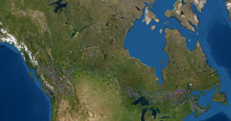
Harvest Year/Mask (1985-2015)
Simple
- Date ( RI_367 )
- 2020
- Date ( RI_366 )
- 2020
(250) 363-6004
https://cfs.nrcan.gc.ca/employes/vue/mwulder
- Hours of service
- email only please
- Status
- onGoing; enContinue RI_596
- Maintenance and update frequency
- asNeeded; auBesoin RI_540
- Keywords
-
- National Terrestrial Ecosystem Monitoring System (NTEMS)
- Government of Canada Core Subject Thesaurus Thésaurus des sujets de base du gouvernement du Canada ( RI_528 )
-
- Harvest
- Forests
- Use limitation
- Open Government Licence - Canada (http://open.canada.ca/en/open-government-licence-canada)
- Access constraints
- otherRestrictions; autresRestrictions RI_609
- Use constraints
- intellectualPropertyRights; droitsPropriétéIntellectuelle RI_607
- Other constraints
- The data represents stand replacing disturbances that occurred between 1985 and 2010. Other changes may be present that are not portrayed here. To avoid confusion in areas with dynamic agricultural land use, an agricultural mask was used in the change detection process. Therefore, changes near agricultural areas may not be captured due to use of this exclusionary mask. An image compositing window of August 1 ± 30 days was used to generate the best-available-pixel (BAP) image composites used as the source data for change detection and attribution. As a result, changes occurring after August 31 may not always be mapped to the correct year; however a national independent accuracy assessment indicated that 97.7% of changes were labelled to within ± 1 year (Hermosilla et al. 2016; http://www.tandfonline.com/doi/full/10.1080/17538947.2016.118767 )
- Spatial representation type
- grid; grille RI_636
- Metadata language
- eng
- Topic category
-
- Geoscientific information
- Begin date
- 1985
- End date
- 2015
))
- Reference system identifier
- http://www.epsg-registry.org / EPSG:3978 / 1.0
- Distribution format
-
-
GeoTIF
(
1.0
)
-
GeoTIF
(
1.0
)
(250) 363-6004
https://ca.nfis.org/index_eng.html
- Hours of service
- email only please
- OnLine resource
-
High Resolution Forest Change for Canada (English)
(
HTTPS
)
Application;HTML;eng
- OnLine resource
-
High Resolution Forest Change for Canada (French)
(
HTTPS
)
Application;HTML;fra
- OnLine resource
-
A nationwide annual characterization of 25 years of forest disturbance and recovery for Canada using Landsat time series
(
HTTP
)
Supporting Document;HTML;eng
- OnLine resource
-
CA_harvest_year_1985_2015
(
OGC:WMS
)
Web Service;WMS;eng
- OnLine resource
-
CA_harvest_year_1985_2015.zip
(
HTTPS
)
Dataset;ZIP;zxx
- OnLine resource
-
CA_harvest_year_1985_2015
(
OGC:WMS
)
Web Service;WMS;fra
- File identifier
- b0c2294c-4471-4235-87e2-5aae34f0b867 XML
- Metadata language
- eng; CAN
- Character set
- utf8; utf8 RI_458
- Hierarchy level
- dataset; jeuDonnées RI_622
- Date stamp
- 2026-02-17T09:55:44
- Metadata standard name
- North American Profile of ISO 19115:2003 - Geographic information - Metadata
- Metadata standard version
- CAN/CGSB-171.100-2009
(250) 363-6004
https://cfs.nrcan.gc.ca/employes/vue/mwulder
- Hours of service
- email only please
Overviews

Spatial extent
Provided by
