 Arctic SDI catalogue
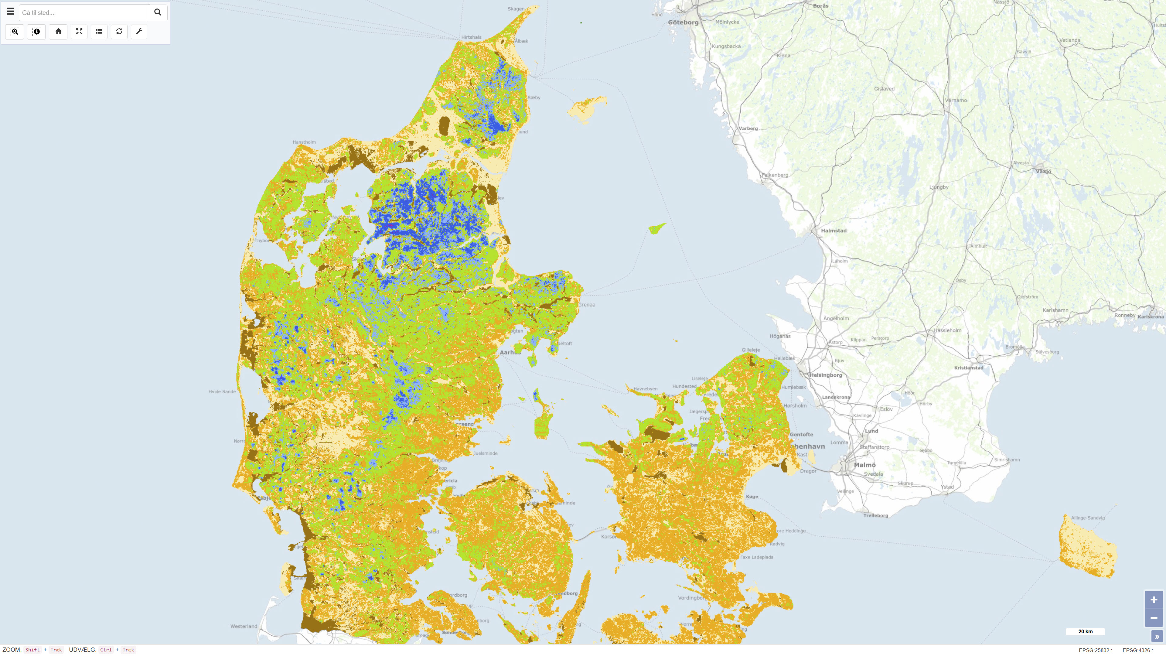
Dybden til redoxgrænsen, 100 m grid
Simple
- Date ( Publication )
- 2019-01-01
- Identifier
- dk.geus / dk_redox_depth_100m
- Presentation form
- Digital map
- Purpose
- The purpose of the dataset is to support national and regional groundwater mapping and assessments of nitrate reduction, groundwater quality, and vulnerability. The map is suitable for use in water management, environmental planning, research, and modelling where knowledge of subsurface redox conditions is required.
- Status
- Completed
- Maintenance and update frequency
- As needed
- Keywords ( Theme )
-
- Dataset
- Geology
- Redox interface
- Groundwater
- Hydrogeology
- Nitrate reduction
- Denmark
- ArcGIS
- Forskningsemner Forskningsemner ( Theme )
- Geografisk Geografisk ( Place )
- Access constraints
- Other restrictions
- Use constraints
- Other restrictions
- Other constraints
- CC BY-NC-SA 4.0
- Spatial representation type
- Grid
- Denominator
- 250000
- Metadata language
- Da
- Character set
- UTF8
- Topic category
-
- Geoscientific information
- Environment
- Begin date
- 2013-01-01
- End date
- 2018-12-31
))
- Supplemental Information
- The dataset replaces an earlier national redox map with a spatial resolution of 1 km × 1 km and represents a substantial improvement in both spatial detail and methodological approach. The map is not subject to continuous updates and should be used in conjunction with local data and expert judgement for detailed investigations.
- Reference system identifier
- ETRS 89 / UTM 32N (EPSG:25832)
- Distribution format
-
-
WMS
(
)
-
WMTS
(
)
-
REST
(
)
-
WMS
(
)
- OnLine resource
-
Download
(
WWW:DOWNLOAD-1.0-http--download
)
Download dataset from GEUS' Dataverse
- OnLine resource
-
Interactive webmap
(
WWW:LINK-1.0-http--link
)
Interactive map displaying the dataset.
- OnLine resource
-
New national redox map at high resolution
(
WWW:LINK-1.0-http--link
)
Professional article presenting the new national high-resolution redox map and explaining the background, methodology, and potential applications related to groundwater and nitrate reduction.
- OnLine resource
-
GEUS releases new national redox map
(
WWW:LINK-1.0-http--link
)
GEUS news article (15-03-2019) introducing the national high-resolution redox map and describing its application in groundwater mapping and environmental management.
- OnLine resource
-
National redox map, 1 km × 1 km
(
WWW:LINK-1.0-http--link
)
Report documenting the previous national redox map with a spatial resolution of 1 km × 1 km, providing a basis for comparison with the newer high-resolution redox map.
- OnLine resource
-
Redox_dybde_100m_grid
(
ESRI:REST
)
ArcGIS REST Service
- OnLine resource
-
Redoxgraensen
(
OGC:WMS-1.3.0-http-get-capabilities
)
ArcGIS WMS Service
- OnLine resource
-
Denmark_Redox_dybde_100m_grid
(
OGC:WMTS-1.0.0-http-get-capabilities
)
ArcGIS WMTS Service
- Hierarchy level
- Dataset
- Statement
- The map is based on approximately 13.000 observations of redox conditions identified as colour changes in sediment samples from boreholes. Based on these observations, a statistical model describing the relationship between depth to the redox interface and a range of explanatory variables was developed. The model was constructed using the machine learning method Random Forest and implemented on a nationwide grid with a spatial resolution of 100 metres. To quantify uncertainty in the estimated depths, residual Gaussian simulation was applied, allowing assessment of spatial variability and model uncertainty. The methodology and model development are documented in the scientific literature.
- File identifier
- b931207c-d386-493a-b5e4-073adb43297c XML
- Metadata language
- Danskda
- Character set
- UTF8
- Hierarchy level
- Dataset
- Date stamp
- 2026-03-19T15:09:19.047731Z
- Metadata standard name
- ISO 19115:2003/19139
- Metadata standard version
- 1.0
Overviews
Spatial extent
Provided by
