 Arctic SDI catalogue
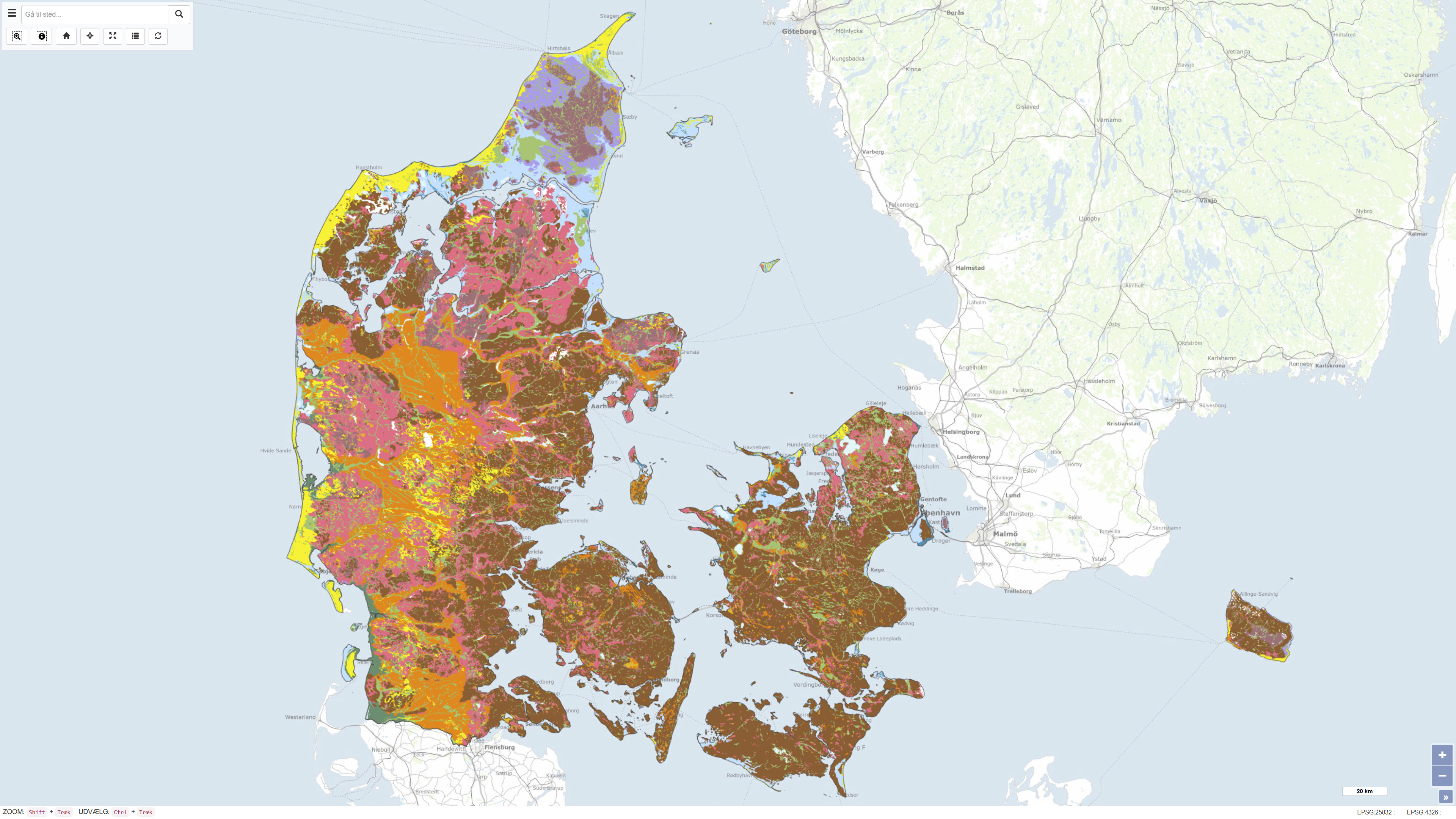
Geological surface map of Denmark 1:200.000
Simple
- Date ( Publication )
- 2011-10-09
- Identifier
- dk.geus / jordartskort_200k
- Presentation form
- Digital map
- Purpose
- The purpose of the dataset is to provide a consistent, nationwide digital map of superficial deposits in Denmark. The map is used as a basis for geological interpretation, environmental management, land-use planning, resource assessment, as well as education and research.
- Status
- Completed
- Maintenance and update frequency
- As needed
- Keywords ( Theme )
-
- Dataset
- Geology
- Soil
- Quaternary
- Surface
- Denmark
- ArcGIS
- Forskningsemner Forskningsemner ( Theme )
- Geografisk Geografisk ( Place )
- Access constraints
- Other restrictions
- Use constraints
- Other restrictions
- Other constraints
- CC BY 4.0
- Spatial representation type
- Vector
- Denominator
- 200000
- Metadata language
- Da
- Character set
- UTF8
- Topic category
-
- Geoscientific information
- Begin date
- 1990-01-01
- End date
- 2011-10-09
))
- Supplemental Information
- The dataset is an interpretation-based national map product and is not subject to continuous updates. It represents a generalised overview of the distribution of superficial deposits at the ground surface and should be used in conjunction with more detailed maps and local data where higher spatial resolution or detailed stratigraphic information is required.
- Reference system identifier
- ETRS 89 / UTM 32N (EPSG:25832)
- Distribution format
-
-
WMS
(
)
-
REST
(
)
-
WMTS
(
)
-
WMS
(
)
- OnLine resource
-
Download
(
WWW:DOWNLOAD-1.0-http--download
)
Download dataset from GEUS' Dataverse
- OnLine resource
-
Interactive webmap
(
WWW:LINK-1.0-http--link
)
Interactive map displaying the dataset.
- OnLine resource
-
Digital map of superficial deposits in Denmark 1:200.000, version 2 – GEUS Report 2011/19
(
DOI
)
Technical GEUS report documenting the data basis, methodology and interpretation behind the digital superficial deposits map at a scale of 1:200.000, version 2.
- OnLine resource
-
Digital map of superficial deposits in Denmark 1:200.000, version 2
(
WWW:LINK-1.0-http--link
)
GEUS publication page providing description and access to the report and related materials.
- OnLine resource
-
Jordartskort_200000
(
ESRI:REST
)
ArcGIS REST Service
- OnLine resource
-
Jordart_200000
(
OGC:WMS-1.3.0-http-get-capabilities
)
ArcGIS WMS Service
- OnLine resource
-
Denmark_Jordartskort_200000
(
OGC:WMTS-1.0.0-http-get-capabilities
)
ArcGIS WMTS Service
- Hierarchy level
- Dataset
- Statement
-
The dataset was compiled by the Geological Survey of Denmark and Greenland (GEUS) and represents version 2 of the digital superficial deposits map at a scale of 1:200.000. The map is based on the compilation and harmonisation of existing geological maps, borehole data, geomorphological analyses and previous Quaternary geological investigations. Version 2 includes updates and improvements compared to earlier versions, including revised deposit boundaries and classifications based on new knowledge and quality assurance.
During compilation of the dataset, generalisation and adjustments have been applied in certain areas, resulting in a spatial uncertainty of up to approximately 200 m, locally slightly more. The dataset is designed as an overview map at a scale of 1:200.000 and is suitable for educational purposes, regional-scale analyses and as background information for other thematic maps. The dataset is not subject to continuous updates and was published in GEUS Report 2011/19.
Mapping of superficial deposits in Denmark has been a core task of the Danish geological surveys since the establishment of the Geological Survey of Denmark (DGU) in 1888. The digital superficial deposits map at a scale of 1:200.000, version 2, builds on this long mapping tradition but represents a modern digital compilation and interpretation based on more recent data and methods.
- File identifier
- ba1a5caa-8019-42c5-9a63-72b32257ca32 XML
- Metadata language
- Danskda
- Character set
- UTF8
- Hierarchy level
- Dataset
- Date stamp
- 2026-02-04T14:36:06.242299Z
- Metadata standard name
- ISO 19115:2003/19139
- Metadata standard version
- 1.0
Overviews
Spatial extent
Provided by
