 Arctic SDI catalogue
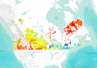
Percent Saturated Surface Soil Moisture
This data series represents the volumetric soil moisture (percent saturated soil) for the surface layer (<5 cm). The data is created daily and is averaged for the ISO standard week and month. The data is produced from passive microwave satellite data collected by the Soil Moisture and Ocean Salinity (SMOS) satellite and converted to soil moisture using version 6.20 of the SMOS soil moisture processor.
The data are produced by the European Space Agency and obtained under a Category 1 proposal for Level 2 soil moisture data. The data are gridded to a resolution of 0.25 degrees. Data quality flags have been applied to remove areas where rainfall is present during the acquisition, where snow cover is detected and when Radio Frequency Interference (RFI) is above an acceptable threshold.
Simple
- Date ( RI_367 )
- 2015-03-06
- Date ( RI_366 )
- 2015-03-06
- Presentation form
- mapDigital;carteNumérique RI_391
- Status
- completed; complété RI_593
- Maintenance and update frequency
- weekly; hebdomadaire RI_534
- Government of Canada Core Subject Thesaurus Thésaurus des sujets de base du gouvernement du Canada ( RI_528 )
-
- Drainage
- Soil
- Hydrology
- Satellites
- Water
- Soil quality
- Remote sensing
- Use limitation
- Open Government Licence - Canada (http://open.canada.ca/en/open-government-licence-canada)
- Access constraints
- license; licence RI_606
- Use constraints
- license; licence RI_606
- Spatial representation type
- grid; grille RI_636
- Metadata language
- eng; CAN
- Topic category
-
- Geoscientific information
- Begin date
- 2010-05-01
))
- Reference system identifier
- http://www.epsg-registry.org/ / EPSG:3857 / 8.3.4
- OnLine resource
-
Data Product Specification (English)
(
HTTPS
)
Supporting Document;PDF;eng
- OnLine resource
-
Biweekly Percent Saturated Surface Soil Moisture Anomalies
(
ESRI REST: Image Service
)
Web Service;ESRI REST;eng
- OnLine resource
-
Biweekly Percent Saturated Surface Soil Moisture Anomalies
(
ESRI REST: Image Service
)
Web Service;ESRI REST;fra
- OnLine resource
-
Weekly Percent Saturated Surface Soil Moisture Anomalies
(
HTTPS
)
Web Service;ESRI REST;fra
- OnLine resource
-
Weekly Percent Saturated Surface Soil Moisture Anomalies
(
HTTPS
)
Web Service;ESRI REST;eng
- OnLine resource
-
Monthly Percent Saturated Surface Soil Moisture Anomalies
(
HTTPS
)
Web Service;ESRI REST;eng
- OnLine resource
-
Monthly Percent Saturated Surface Soil Moisture Anomalies
(
HTTPS
)
Web Service;ESRI REST;fra
- OnLine resource
-
The SMOS Soil Moisture Retrieval Algorithm
(
HTTPS
)
Supporting Document;PDF;eng
- OnLine resource
-
Data Product Specification (French)
(
HTTPS
)
Supporting Document;PDF;fra
- OnLine resource
-
Pre-packaged GeoTIF files (No linguistic component)
(
HTTPS
)
Dataset;GeoTIF;zxx
- OnLine resource
-
Pre-packaged Maps (Bilingual)
(
HTTPS
)
Dataset;PDF;eng,fra
- OnLine resource
-
Percent Saturated Surface Soil Moisture from SMOS Satellite Data (English)
(
HTTPS
)
Application;Web App;eng
- OnLine resource
-
Percent Saturated Surface Soil Moisture from SMOS Satellite Data (French)
(
HTTPS
)
Application;Web App;fra
- File identifier
- c0ea8c27-e62e-45bc-b64c-d475650d84a2 XML
- Metadata language
- eng; CAN
- Character set
- utf8; utf8 RI_458
- Hierarchy level
- series; série RI_623
- Date stamp
- 2025-05-15T17:46:38
- Metadata standard name
- North American Profile of ISO 19115:2003 - Geographic information - Metadata
- Metadata standard version
- CAN/CGSB-171.100-2009
Overviews
Spatial extent
Provided by
