 Arctic SDI catalogue
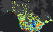
North America Surface Water Values
The North America Surface Water Values point dataset contains the current water level and stream flow values as recorded by Canadian and USA hydrometric gauging station locations.
Daily values are recorded as well as comparisons with historical measurements, including difference in values from the previous day, the mean level for that calendar date, the annual mean water level, and maximum and minumum recorded levels. Percentile values based on historical average for both water level and stream flow are also included.
Real-time gauging station data for Canada is available here: https://wateroffice.ec.gc.ca/search/statistics_e.html
Real-time gauging station data for the United States is available here: https://waterservices.usgs.gov/rest/Statistics-Service.html
Simple
- Date ( RI_367 )
- 2017-06-19
- Date ( RI_366 )
- 2017-06-19
- Status
- completed; complété RI_593
- Maintenance and update frequency
- daily; quotidien RI_533
- Government of Canada Core Subject Thesaurus Thésaurus des sujets de base du gouvernement du Canada ( RI_528 )
-
- Water supply
- Surface water
- Use limitation
- Open Government Licence - Canada (http://open.canada.ca/en/open-government-licence-canada)
- Access constraints
- license; licence RI_606
- Use constraints
- license; licence RI_606
- Spatial representation type
- vector; vecteur RI_635
- Metadata language
- eng; CAN
- Character set
- utf8; utf8 RI_458
- Topic category
-
- Inland waters
- Environment
- Begin date
- 2017-01-01
))
- Reference system identifier
- http://www.epsg-registry.org / EPSG:3857 / 8.1.4
- Distribution format
-
-
ESRI REST
(
10.4
)
-
ESRI REST
(
10.4
)
- OnLine resource
-
Data Product Specification
(
HTTPS
)
Supporting Document;PDF;eng
- OnLine resource
-
Data Product Specification
(
HTTPS
)
Supporting Document;PDF;fra
- OnLine resource
-
Water Level - Current (m)
(
ESRI REST: Feature Service
)
Web Service;ESRI REST;eng,fra
- OnLine resource
-
Water Level - Current (m)
(
ESRI REST: Feature Service
)
Web Service;ESRI REST;eng,fra
- File identifier
- c42ebfac-1af2-4e62-a15f-b36c35d634c9 XML
- Metadata language
- eng; CAN
- Character set
- utf8; utf8 RI_458
- Hierarchy level
- dataset; jeuDonnées RI_622
- Date stamp
- 2025-01-24T16:34:56
- Metadata standard name
- North American Profile of ISO 19115:2003 - Geographic information - Metadata
- Metadata standard version
- CAN/CGSB-171.100-2009
Overviews


Spatial extent
Provided by
