 Arctic SDI catalogue
Vase tunicate (Ciona intestinalis) - Aquatic Invasive Species Program - Newfoundland and Labrador Region
AIS NL Biofouling Species
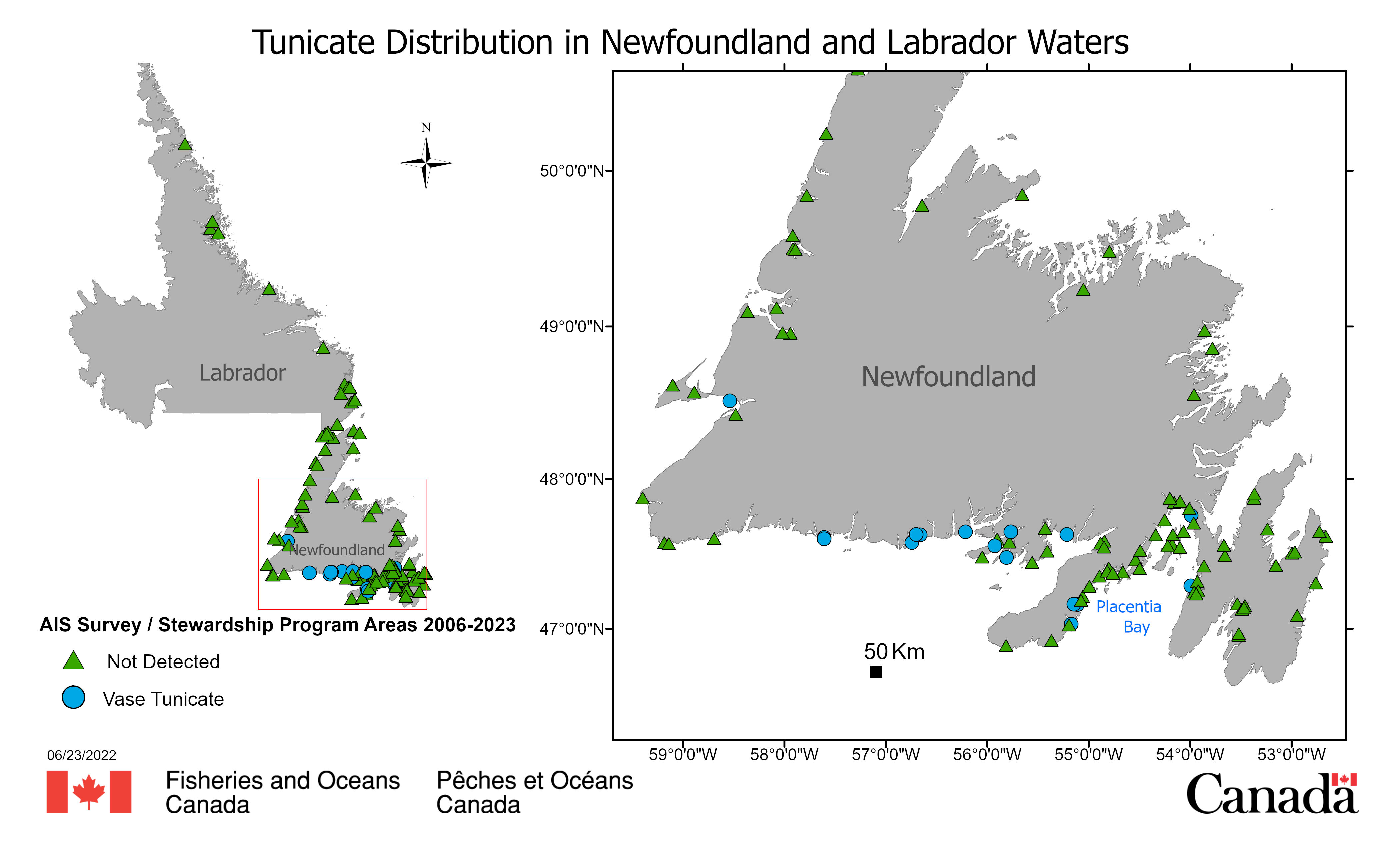
Fisheries and Oceans Canada's (DFO) National Marine Biofouling Monitoring Program conducts annual field surveys to monitor the introduction, establishment, spread, species richness, and relative abundance of native and some non-native species in Newfoundland and Labrador (NL) Region since 2006. Standardized monitoring protocols employed by DFO's NL, Maritimes, Gulf, and Quebec regions include biofouling collector plates deployed from May to October at georeferenced intertidal and shallow subtidal sites, including public docks, and public and private marinas and nautical clubs. Initially, (2006-2017), the collectors consisted of three 10 cm by 10 cm PVC plates deployed in a vertical array and spaced approximately 40 cm apart, with the shallowest plate suspended at least 1 m below the surface to sample subtidal and shallow intertidal species (McKenzie et al 2016a). Three replicate arrays were deployed at least 5 m apart per site. Since 2018, collector networks have been modified to improve statistical replication, including up to 10 individual collectors deployed per site at 1 m depth and at least 5 m apart (as above) from May to October. Since 2006, seven invasive biofouling organisms have been detected in Newfoundland and Labrador harbours, marinas and coastal areas.
Should be cited as follows: DFO Newfoundland and Labrador Region Aquatic Invasive Species Marine Biofouling Monitoring Program. Published March 2024. Coastal and Freshwater Ecology, Northwest Atlantic Fisheries Centre, Fisheries and Oceans Canada, St. John’s, Newfoundland and Labrador.
Reference:
Tunicates
Vase tunicate (Ciona intestinalis) 2012
The Vase tunicate, is a high impact solitary invader and was first detected by DFO in 2012 on the Burin Peninsula at Ship Cove and Little Bay, Placentia Bay. Various mitigation measures (McKenzie et al. 2016b) contained this invasive tunicate to a small area for six years within Placentia Bay. First detected in Fortune Bay as an established population in 2019, increasing reports of the Vase tunicate have been made along the south coast of Newfoundland. The data provided here indicates the detections of this AIS in coastal NL.
From 2018-2022, the Coastal Environmental Baseline Program provided additional support to enhance sampling efforts in Placentia Bay.
Simple
- Date ( RI_367 )
- 2025
- Date ( RI_366 )
- 2025
- Status
- onGoing; enContinue RI_596
- Maintenance and update frequency
- asNeeded; auBesoin RI_540
- Government of Canada Core Subject Thesaurus Thésaurus des sujets de base du gouvernement du Canada ( RI_528 )
-
- Oceans
- Geographic data
- Geographic information systems
- Marine biology
- Environment
- Classification
- unclassified; nonClassifié RI_484
- Use limitation
- Open Government Licence - Canada (http://open.canada.ca/en/open-government-licence-canada)
- Access constraints
- license; licence RI_606
- Use constraints
- license; licence RI_606
- Spatial representation type
- vector; vecteur RI_635
- Metadata language
- eng; CAN
- Character set
- utf8; utf8 RI_458
- Topic category
-
- Oceans
- Biota
- Geoscientific information
- Location
- Environment
- Begin date
- 2012
- End date
- 2024
))
- Reference system identifier
- https://epsg.io / EPSG:4326 /
- Distribution format
-
-
SHP
(
1.0
)
-
SHP
(
1.0
)
- OnLine resource
-
data-dictionary_EN.csv
(
HTTPS
)
Supporting Document;CSV;eng
- OnLine resource
-
data-dictionary_FR
(
HTTPS
)
Supporting Document;CSV;fra
- OnLine resource
-
data_EN
(
HTTPS
)
Dataset;CSV;eng
- OnLine resource
-
data_FR
(
HTTPS
)
Dataset;CSV;fra
- OnLine resource
-
SHP_EN/FR
(
HTTPS
)
Dataset;SHP;eng,fra
- OnLine resource
-
Web Map Service
(
ESRI REST: Map Service
)
Web Service;ESRI REST;eng
- OnLine resource
-
Web Map Service
(
ESRI REST: Map Service
)
Web Service;ESRI REST;fra
- File identifier
- c4a7e1c5-ec4f-4ea0-990a-8471b966dd7a XML
- Metadata language
- eng; CAN
- Character set
- utf8; utf8 RI_458
- Parent identifier
- Aquatic Invasive Species Program - Newfoundland and Labrador Region 4ba00548-02b8-48d7-9ff9-a3681bce39cd
- Hierarchy level
- series; série RI_623
- Date stamp
- 2025-04-22T12:32:10.71Z
- Metadata standard name
- North American Profile of ISO 19115:2003 - Geographic information - Metadata
- Metadata standard version
- CAN/CGSB-171.100-2009
Overviews
Spatial extent
Provided by
