 Arctic SDI catalogue
Markhöjdmodell Nedladdning, grid 1+
Rikstäckande höjddata i form av ett regelbundet rutnät med 1 meters upplösning. En terrängmodell skapad utifrån mark- och vattenpunkter i laserdata. Uppdateras kontinuerligt utifrån laserdata och bildmatchning.
Simple
- Alternate title
- Terrain Model Download, grid 1+
- Date ( Publication )
- 2021-01-04
- Identifier
- 259d378c-89ff-4191-85a0-e29cbc990463
- Status
- On going
- Maintenance and update frequency
- Continual
- Maintenance note
- Uppdateras kontinuerligt utifrån laserdata och bildmatchning
- Initiativ ( Theme )
-
- Geodatasamverkan
- Access constraints
- Other restrictions
- Other constraints
- Immateriella rättigheter
- Use constraints
- Other restrictions
- Other constraints
- Creative commons Erkännande 4.0 Internationell
- Access constraints
- Other restrictions
- Other constraints
- Immateriella rättigheter - Upphovsrätt
- Spatial representation type
- Grid
- Distance
- 1 meter
- Metadata language
- sv
- Topic category
-
- Elevation
- Environment description
- MetadataEditor=Geodata.Sverige.ExtJSEditor_1.0
- Description
- Rikstäckande
- Geographic identifier
- Sverige
N
S
E
W
))
Vertical extent
- Minimum value
- -100
- Maximum value
- 2200
- Reference system identifier
- EPSG / http://www.opengis.net/def/crs/EPSG/0/3006
- Reference system identifier
- EPSG / http://www.opengis.net/def/crs/EPSG/0/3007
- Reference system identifier
- EPSG / http://www.opengis.net/def/crs/EPSG/0/3008
- Reference system identifier
- EPSG / http://www.opengis.net/def/crs/EPSG/0/3012
- Reference system identifier
- EPSG / http://www.opengis.net/def/crs/EPSG/0/3009
- Reference system identifier
- EPSG / http://www.opengis.net/def/crs/EPSG/0/3013
- Reference system identifier
- EPSG / http://www.opengis.net/def/crs/EPSG/0/3010
- Reference system identifier
- EPSG / http://www.opengis.net/def/crs/EPSG/0/3014
- Reference system identifier
- EPSG / http://www.opengis.net/def/crs/EPSG/0/3011
- Reference system identifier
- EPSG / http://www.opengis.net/def/crs/EPSG/0/3015
- Reference system identifier
- EPSG / http://www.opengis.net/def/crs/EPSG/0/3016
- Reference system identifier
- EPSG / http://www.opengis.net/def/crs/EPSG/0/3017
- Reference system identifier
- EPSG / http://www.opengis.net/def/crs/EPSG/0/3018
Distributor
- Name
- GEOTIFF - LZW
- OnLine resource
-
Produktsida för Markhöjdmodell Nedladdning, grid 1+
(
HTTP:Information
)
Produktsida för Markhöjdmodell Nedladdning, grid 1+
- Hierarchy level
- Series
Conformance result
- Date ( Publication )
- 2010-12-08
- Explanation
- https://www.geodata.se/globalassets/dokumentarkiv/regelverk/inspire/ir_interoperabilitet.pdf
- Pass
- Yes
Conformance result
- Date ( Publication )
- 2010-12-08
- Explanation
- https://www.geodata.se/globalassets/dokumentarkiv/regelverk/inspire/ir_interoperabilitet.pdf
- Pass
- Yes
Conformance result
- Date ( Publication )
- 2010-12-08
- Explanation
- https://www.geodata.se/globalassets/dokumentarkiv/regelverk/inspire/ir_interoperabilitet.pdf
- Pass
- Yes
Conformance result
- Date ( Publication )
- 2010-12-08
- Explanation
- https://www.geodata.se/globalassets/dokumentarkiv/regelverk/inspire/ir_interoperabilitet.pdf
- Pass
- Yes
Conformance result
- Date ( Publication )
- 2010-12-08
- Explanation
- https://www.geodata.se/globalassets/dokumentarkiv/regelverk/inspire/ir_interoperabilitet.pdf
- Pass
- Yes
Conformance result
- Date ( Publication )
- 2010-12-08
- Explanation
- https://www.geodata.se/globalassets/dokumentarkiv/regelverk/inspire/ir_interoperabilitet.pdf
- Pass
- Yes
- Statement
-
Laserskanning från flygplan. Laserpunktmolnet genomgår kvalitetsgranskning och klassificering av laserpunkter till mark, vatten, broar och övrigt.
Utifrån mark- och vattenpunkter skapas sedan höjdmodell (grid).
- File identifier
- c510e63f-0bf3-46c9-ab8b-3b37a898af85 XML
- Metadata language
- sv
- Hierarchy level
- Series
- Date stamp
- 2026-06-22T07:06:13.647Z
- Metadata standard name
- SS-EN-ISO-19115:2005-NMDP 4.0
- Metadata standard version
- 4.0
Overviews
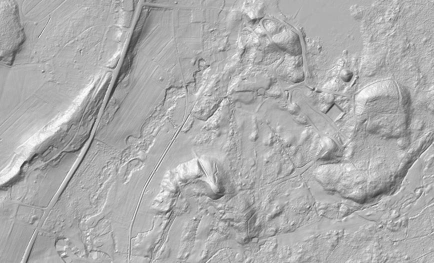
Terrängmodell som visas med terrängskuggning.
Spatial extent
N
S
E
W
Provided by

Associated resources
Not available