 Arctic SDI catalogue
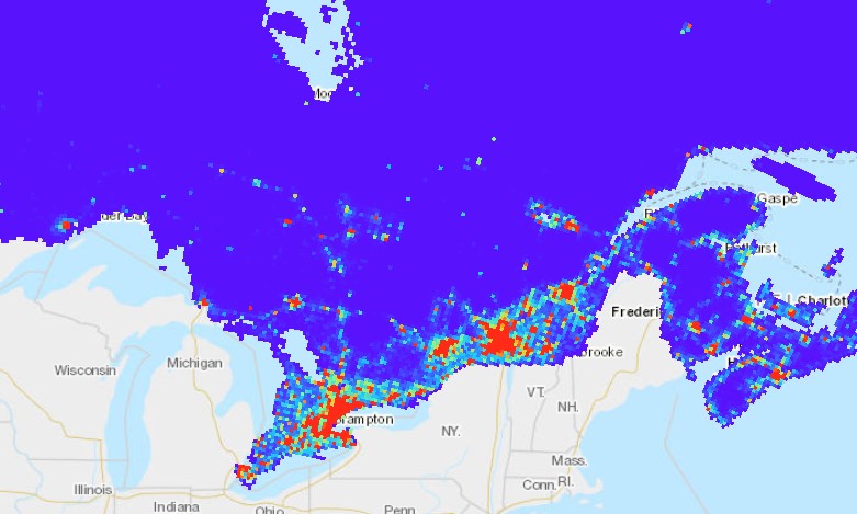
Population of Canada, 10km Gridded
The Population of Canada, 10km Gridded national scale datasets display the distribution and areal extent of rural, urban and total populations across Canada for both 2011 and 2016. The 10km gridded framework is the same 10km gridded framework used within the Biomass Inventory Mapping and Analysis Tool. This data was created for AAFC by Statistics Canada using AAFC’s 10km gridded framework.
The purpose of this data is to display the distribution of rural and urban populations across a 10km x 10km grid of Canada.
Simple
- Date ( RI_367 )
- 2019-12-12
- Date ( RI_366 )
- 2019-12-12
- Presentation form
- mapDigital;carteNumérique RI_391
- Status
- completed; complété RI_593
- Maintenance and update frequency
- notPlanned; nonPlanifié RI_542
- Government of Canada Core Subject Thesaurus Thésaurus des sujets de base du gouvernement du Canada ( RI_528 )
-
- Rural communities
- Urban communities
- Population
- Use limitation
- Open Government Licence - Canada (http://open.canada.ca/en/open-government-licence-canada)
- Access constraints
- license; licence RI_606
- Use constraints
- license; licence RI_606
- Spatial representation type
- vector; vecteur RI_635
- Spatial representation type
- vector; vecteur RI_635
- Metadata language
- eng; CAN
- Topic category
-
- Society
- Begin date
- 2011-01-01
- End date
- 2016-01-01
))
- Reference system identifier
- http://www.epsg.org/ / EPSG:3857 / 8.3.4
- OnLine resource
-
Population of Canada 2011, 10km Gridded
(
HTTPS
)
Web Service;ESRI REST;eng
- OnLine resource
-
Population of Canada 2016, 10km Gridded
(
HTTPS
)
Web Service;ESRI REST;eng
- OnLine resource
-
Population of Canada 2011, 10km Gridded
(
HTTPS
)
Web Service;ESRI REST;fra
- OnLine resource
-
Population of Canada 2016, 10km Gridded
(
HTTPS
)
Web Service;ESRI REST;fra
- OnLine resource
-
Population of Canada, 10km Gridded
(
HTTPS
)
Dataset;FGDB/GDB;zxx
- OnLine resource
-
Population of Canada, 10km Gridded
(
HTTPS
)
Dataset;GPKG;zxx
- OnLine resource
-
Population of Canada 2011, 10km Gridded
(
HTTPS
)
Dataset;SHP;zxx
- OnLine resource
-
Population of Canada 2016, 10km Gridded
(
HTTPS
)
Dataset;SHP;zxx
- OnLine resource
-
Data Product Specification (English)
(
HTTPS
)
Supporting Document;PDF;eng
- OnLine resource
-
Data Product Specification (French)
(
HTTPS
)
Supporting Document;PDF;fra
- File identifier
- c6c48391-fd2f-4d8a-93c8-eb74f58a859b XML
- Metadata language
- eng; CAN
- Character set
- utf8; utf8 RI_458
- Hierarchy level
- series; série RI_623
- Date stamp
- 2026-01-08T14:25:02
- Metadata standard name
- North American Profile of ISO 19115:2003 - Geographic information - Metadata
- Metadata standard version
- CAN/CGSB-171.100-2009
Overviews
Spatial extent
Provided by
