 Arctic SDI catalogue
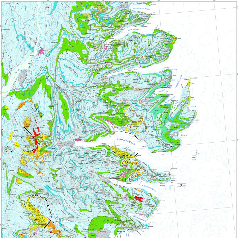
Jarðfræðikort af Austurlandi 1. útgáfa – 1:100.000
Gagnasafn (GDB) NI_J100v_Austurland_1.utg:
Jarðfræðikort af Austurlandi í mælikvarði 1:100.000, 1. útg. [Geological map of Eastern Iceland in the scale of 1:100.000, 1st ed.]
Jarðfræðikort af Austurlandi nær yfir svæði frá Berufirði yfir í Mjóafjörð. Berggrunnur er flokkaður eftir gerð og samsetningu. Kortið sýnir túff (gjóskulög), gíga, öskjurima, sprungur, misgengi, strik og halla, framhlaup, steingervinga, lindir og mörk segulskeiðsins C5n.
[The Geological map of Eastern Iceland covers the area from Berufjörður up to Mjóifjörður. Bedrock is classified by type and composition. The map shows tuff layers, craters, caldera rims, fissures, faults, strike and dip, landslides, fossils, springs and the base of magnetic chron C5n.]
Simple
- Date ( Publication )
- 2019-12-31
- Edition
- 1. útg.
- Date
- Unique resource identifier
- Other citation details
- Tilvísun: Birgir V. Óskarsson og Martin J. Riishuus 2019. Jarðfræðikort af Austurlandi. 1:100.000. 1. útg. Garðabær: Náttúrufræðistofnun Íslands. Bibliograðhic reference: Óskarsson, B.V. and Riishuus, M.S. 2019. Geological Map of Eastern Iceland. 1:100.000. 1st edition. Garðabær: Icelandic Institute of Natural History.
- Status
- On going
- Maintenance and update frequency
- As needed
- Keywords ( Place )
-
- National
- GEMET - INSPIRE themes, version 1.0 ( Theme )
-
- Geology
- Keywords ( Theme )
-
- GSL
- GSL flokkun ( Theme )
- Access constraints
- Copyright
- Other constraints
-
https://www.natt.is/is/midlun/opin-gogn
Gögnin eru öllum opin – no limitations on public access
- Spatial representation type
- Vector
- Denominator
- 100000
- Metadata language
- is
- Character set
- UTF8
- Topic category
-
- Geoscientific information
))
- Begin date
- 2019-06-30
- End date
- 2019-12-31
Vertical extent
- Reference system identifier
- EPSG / 3057
- Distribution format
-
-
ESRI ArcGIS File Geodatabase
(
10.7.0.10450
)
-
ESRI Shapefile
(
10.7.0.10450
)
-
ESRI ArcGIS File Geodatabase
(
10.7.0.10450
)
- OnLine resource
- Niðurhal gagna ( WWW:LINK-1.0-http--link )
- OnLine resource
- NÁTT kortasjá 'Jarðfræði Íslands' ( WWW:LINK-1.0-http--link )
- OnLine resource
- Feltgögn og kort eftir breska jarðfræðinginn George P. L. Walker ( WWW:LINK-1.0-http--link )
- OnLine resource
- Vefur Náttúrufræðistofnunar ( WWW:LINK-1.0-http--link )
- OnLine resource
- Íslenskt fitjuskrá '600 Jarðmyndun og landmótun' sem tengjast staðlinum ÍST 120 (PDF) ( WWW:LINK-1.0-http--link )
- OnLine resource
- Skilmálar (PDF) – Licence (PDF) ( WWW:LINK-1.0-http--link )
- OnLine resource
-
ni:ni_j100v_austurland_berggrunnur_1utg_fl
(
OGC:WMS
)
Jarðfræði Austurland berggrunnur
- OnLine resource
-
ni:ni_j100v_austurland_berggrunnur_mork_1utg_li
(
OGC:WMS
)
Jarðfræði Austurland berggrunnur mörk
- OnLine resource
-
ni:ni_j100v_austurland_millilog_1utg_li
(
OGC:WMS
)
Jarðfræði Austurland millilög
- OnLine resource
-
ni:ni_j100v_austurland_anomalia_c5n_1utg_li
(
OGC:WMS
)
Jarðfræði Austurland segulanomalia
- OnLine resource
-
ni:ni_j100v_austurland_gigar_1utg_li
(
OGC:WMS
)
Jarðfræði Austurland gígar - línur
- OnLine resource
-
ni:ni_j100v_austurland_gigar_1utg_fl
(
OGC:WMS
)
Jarðfræði Austurland gígar - svæði
- OnLine resource
-
ni:ni_j100v_austurland_hoggun_1utg_li
(
OGC:WMS
)
Jarðfræði Austurland höggun
- OnLine resource
-
ni:ni_j100v_austurland_steingervingar_1utg_p
(
OGC:WMS
)
Jarðfræði Austurland steingervingar
- OnLine resource
-
ni:ni_j100v_austurland_skridur_1utg_li
(
OGC:WMS
)
Jarðfræði Austurland skriður
- OnLine resource
-
ni:ni_j100v_austurland_strik_halli_1utg_p
(
OGC:WMS
)
Jarðfræði Austurland halli
- Hierarchy level
- Dataset
- Statement
-
Höfundar kortsins eru Birgir V. Óskarsson og Morten S. Riishuus jarðfræðingar sem unnu að kortlagningu svæðisins og tengingu eldri korta. Sjá heimildir á útprentuðu korti (Birgir V. Óskarsson og Morten S. Riishuus 2019. Jarðfræðikort af Austurlandi. 1:100.000. 1. útg. Garðabær: Náttúrufræðistofnun Íslands). Sjá nánar með hvert lög.
[The authors of the map are Birgir V. Óskarsson and Morten S. Riishuus geologists that compiled the maps and correlated and mapped the geological layers and formations. See reference list in printed map (Óskarsson, B.V. and Riishuus, M.S. 2019. Geological Map of Eastern Iceland. 1:100 000. 1st edition. Garðabær: Icelandic Institute of Natural History). See more detailed information at the individual layers.]
- File identifier
- c907fbd3-7420-4c0b-81e4-b877514ba8c5 XML
- Metadata language
- en
- Character set
- UTF8
- Hierarchy level
- Dataset
- Date stamp
- 2025-12-04T11:40:54
- Metadata standard name
- INSPIRE Metadata Implementing Rules
- Metadata standard version
- Technical Guidelines based on EN ISO 19115 and EN ISO 19119 (Version 1.2)
Overviews
Spatial extent
Provided by
