 Arctic SDI catalogue
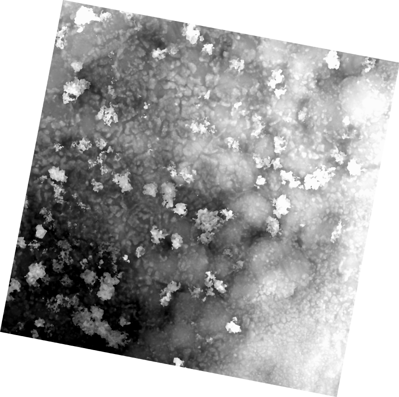
UAV Digital Surface Model (DSM) in Cambridge Bay, Nunavut -Vegetation Plot
The 1 cm resolution digital surface model (DSM) was created from unmanned aerial vehicle (UAV) imagery acquired from a single day survey, July 28th 2016, in Cambridge Bay, Nunavut. Five control points taken from a Global Differential Positioning System were positioned in the corners and the center of the vegetation survey. The DSM covering 525m2 was produced by Canada Centre for Remote Sensing /Canada Centre for Mapping and Earth Observation. The UAV survey was completed in collaboration with the Canadian High Arctic Research Station (CHARS) for northern vegetation monitoring research.
For more information, refer to our current Arctic vegetation research:
Fraser et al; "UAV photogrammetry for mapping vegetation in the low-Arctic" Arctic Science, 2016, 2(3): 79-102. http://www.nrcresearchpress.com/doi/abs/10.1139/AS-2016-0008
Simple
- Date ( RI_366 )
- 2017-01-13
- Date ( RI_367 )
- 2017-02-03
- Status
- completed; complété RI_593
- Maintenance and update frequency
- notPlanned; nonPlanifié RI_542
- Keywords ( RI_529 )
-
- UAV
- unmanned aerial vehicle
- digital surface model
- DSM
- northern
- Government of Canada Core Subject Thesaurus Thésaurus des sujets de base du gouvernement du Canada ( RI_528 )
-
- Remote sensing
- Cartography
- Geographic data
- Geomatics
- Use limitation
- Open Government Licence - Canada (http://open.canada.ca/en/open-government-licence-canada)
- Access constraints
- otherRestrictions; autresRestrictions RI_609
- Use constraints
- copyright; droitAuteur RI_602
- Other constraints
-
Please include above copyright notice:
© Department of Natural Resources Canada. All rights reserved.
- Spatial representation type
- grid; grille RI_636
- Metadata language
- no linguistic content
- Topic category
-
- Imagery base maps earth cover
- Begin date
- 2016-07-28
- End date
- 2016-07-28
))
- Reference system identifier
- http://www.epsg-registry.org / EPSG:3978 /
- Reference system identifier
- / EPSG:32613 /
- Distribution format
-
-
WMS
(
1.3.0
)
-
TIFF
(
Unknown
)
-
WMS
(
1.3.0
)
- OnLine resource
-
UAV Digital Surface Model - 1 cm / Vegetation Plot - Cambridge Bay (Nunavut)
(
HTTPS
)
Web Service;WMS;eng
- OnLine resource
-
UAV Digital Surface Model - 1 cm / Vegetation Plot - Cambridge Bay (Nunavut)
(
HTTPS
)
Web Service;WMS;fra
- OnLine resource
-
UAV Digital Surface Model (DSM) in Cambridge Bay, Nunavut -Vegetation Plot
(
HTTPS
)
Dataset;TIFF;zxx
- File identifier
- ca8e95d4-c4fb-49d2-9917-f1a5603e1df4 XML
- Metadata language
- eng; CAN
- Character set
- utf8; utf8 RI_458
- Hierarchy level
- dataset; jeuDonnées RI_622
- Date stamp
- 2022-02-09T20:03:49
- Metadata standard name
- North American Profile of ISO 19115:2003 - Geographic information - Metadata
- Metadata standard version
- CAN/CGSB-171.100-2009
Overviews


Spatial extent
Provided by
