 Arctic SDI catalogue
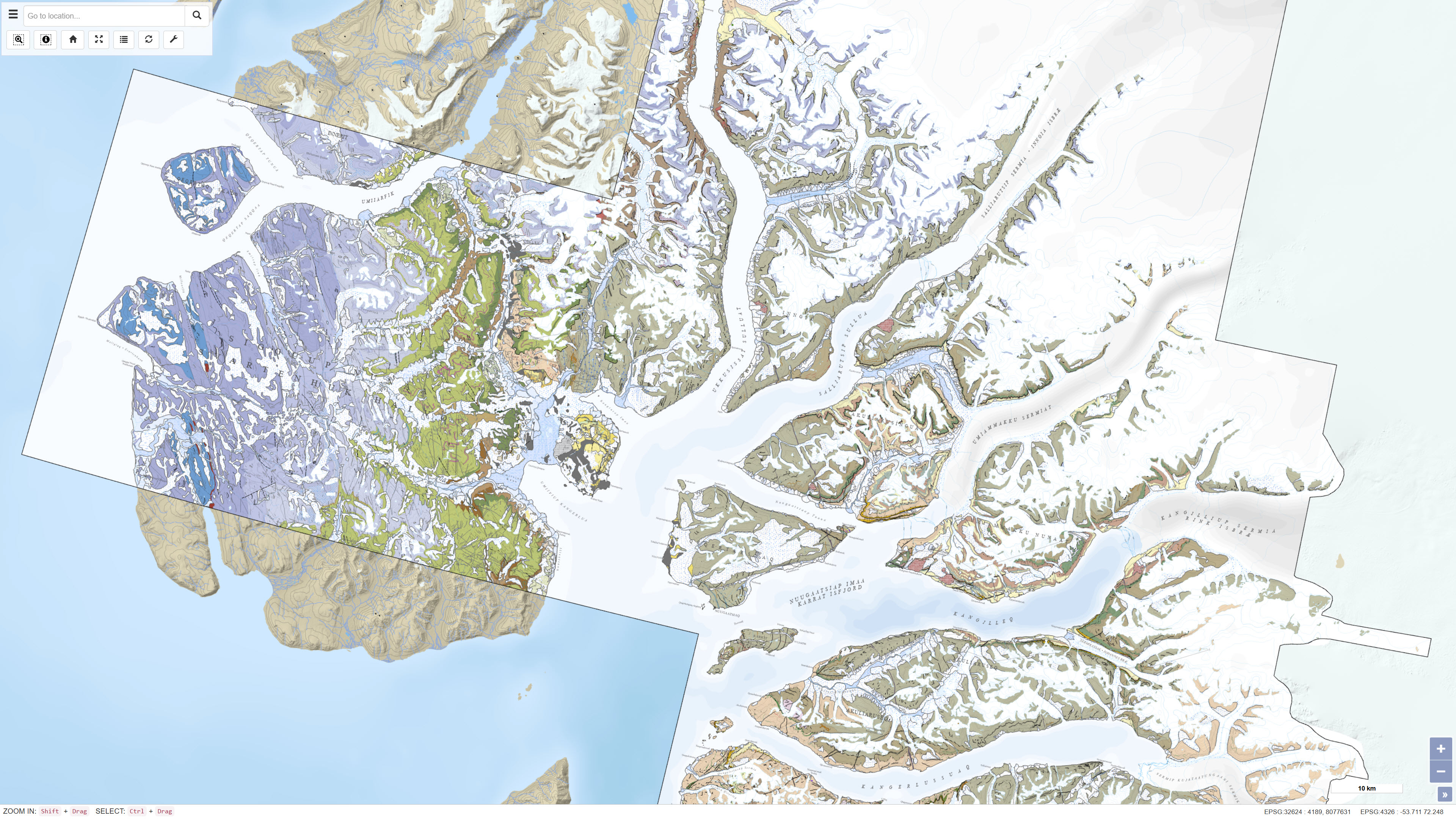
Geological map of the Karrat area 1:100.000
Simple
- Date ( Publication )
- 2025-01-01
- Identifier
- dk.geus / grl_geological_map_karrat_100k
- Presentation form
- Digital map
- Purpose
- The purpose of the dataset is to provide an updated digital geological map of the Karrat area for research, geological mapping, mineral exploration and general geoscientific applications. The dataset supports analysis of stratigraphy, structural geology and regional geological relationships in central West Greenland.
- Status
- Completed
- Maintenance and update frequency
- As needed
- Keywords ( Theme )
-
- Dataset
- Geology
- Geological maps
- Karrat
- West Greenland
- Stratigraphy
- Structural geology
- Geodata
- ArcGIS
- Forskningsemner Forskningsemner ( Theme )
- Geografisk Geografisk ( Place )
- Access constraints
- Other restrictions
- Use constraints
- Other restrictions
- Other constraints
- CC BY 4.0
- Other constraints
- The dataset is licensed under the Creative Commons Attribution 4.0 International license (CC BY 4.0). When using the dataset, the Geological Survey of Denmark and Greenland (GEUS) must be cited as data provider.
- Spatial representation type
- Vector
- Denominator
- 100000
- Metadata language
- Da
- Character set
- UTF8
- Topic category
-
- Geoscientific information
))
- Supplemental Information
-
The dataset represents a harmonised and seamless digital compilation of four geological map sheets at a scale of 1:100 000 from the Karrat area in central West Greenland. The map product is available as printed maps, PDF products and Web-GIS services. The dataset was developed using 3D photogeology combined with traditional field observations, geochemical analyses and geochronological investigations. The map should be used with consideration of the map scale and regional level of generalisation.
Recommended citation: Guarnieri, Pierpaolo; Baker, Nigel; Rosa, Diogo; Sørensen, Erik Vest; Larsen, J.G., 2025, Geological map of the Karrat area 1:100 000.
- Reference system identifier
- WGS 84 / UTM 24N (EPSG:32624)
- Distribution format
-
-
WMS
(
)
-
WMTS
(
)
-
WMS
(
)
- OnLine resource
-
Geological map of Greenland 1:100.000, Maarmorilik 71 V. 2 Syd
(
WWW:DOWNLOAD-1.0-http--download
)
Download dataset from GEUS' Dataverse.
- OnLine resource
-
Interactive webmap
(
WWW:LINK-1.0-http--link
)
Interactive map displaying the dataset.
- OnLine resource
-
Geological map of Greenland 1:100.000, Pannertooq 72 V. 2 Syd
(
WWW:DOWNLOAD-1.0-http--download
)
Download dataset from GEUS' Dataverse.
- OnLine resource
-
Geological map of Greenland 1:100.000, Nuugaatsiaq 71 V. 2 Nord
(
WWW:DOWNLOAD-1.0-http--download
)
Download dataset from GEUS' Dataverse.
- OnLine resource
-
Geological map of Greenland 1:100.000, Svartenhuk 71 V.1 Nord
(
WWW:DOWNLOAD-1.0-http--download
)
Download dataset from GEUS' Dataverse.
- Hierarchy level
- Dataset
- Statement
- The dataset is based on geological mapping carried out by GEUS in collaboration with the Ministry of Mineral Resources and Justice of Greenland in the fjord regions north of Uummannaq in central West Greenland. Mapping included 3D photogeological interpretation based on more than 35,000 oblique photographs collected during three field seasons combined with traditional field observations. In addition, more than 700 samples were analysed for geochemistry and nearly 100 samples were analysed for geochronology. The dataset compiles and harmonises four geological map sheets at a scale of 1:100 000 into a seamless digital map product.
- File identifier
- cc8b031c-4c9e-4cb1-a28e-1fbeae8afda0 XML
- Metadata language
- Danskda
- Character set
- UTF8
- Hierarchy level
- Dataset
- Date stamp
- 2026-08-23T09:54:37.392713Z
- Metadata standard name
- ISO 19115:2003/19139
- Metadata standard version
- 1.0
Overviews
Spatial extent
Provided by
