 Arctic SDI catalogue
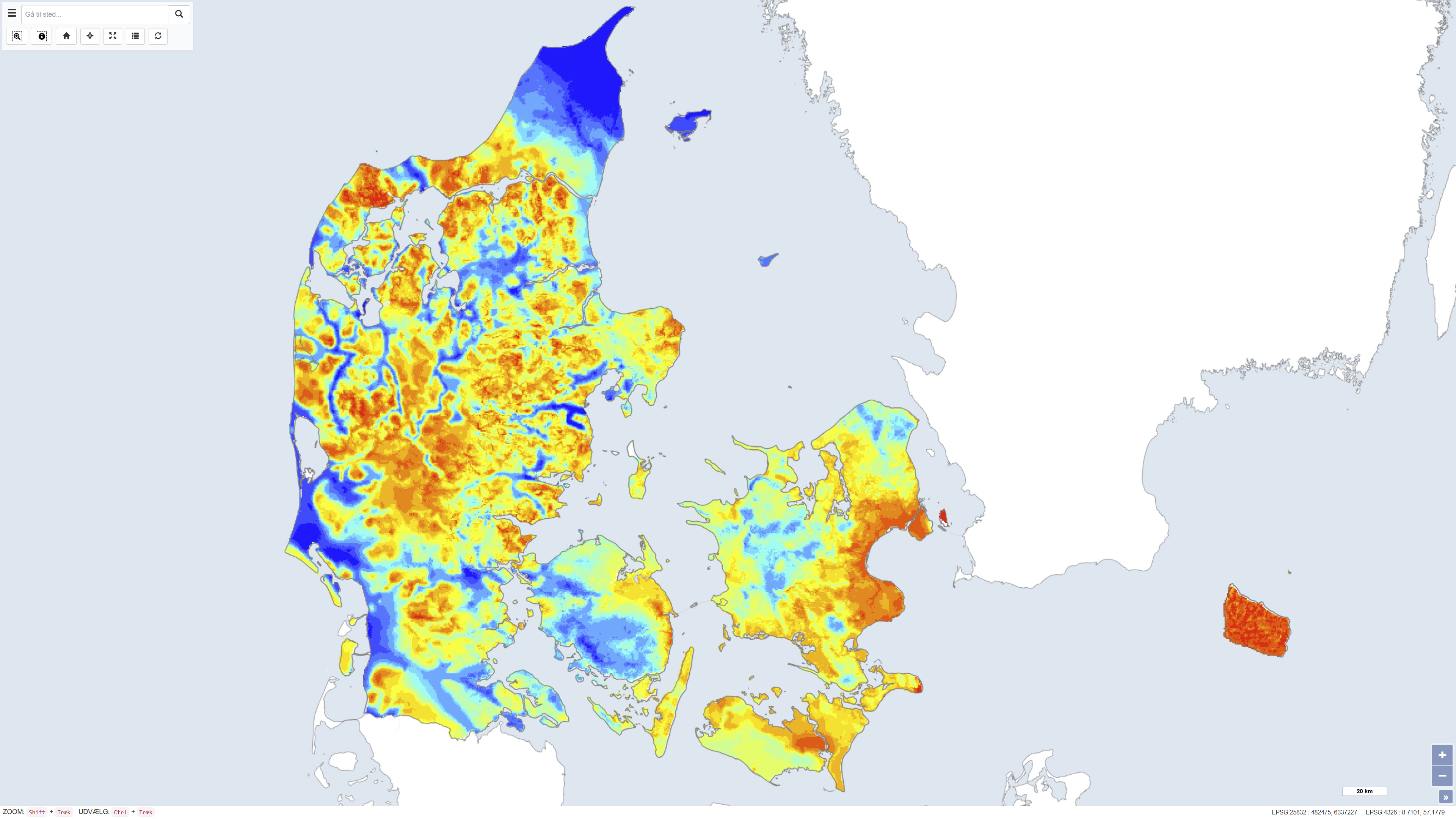
Quaternary thickness of Denmark
Simple
- Date ( Publication )
- 2012-02-07
- Identifier
- dk.geus / INDSÆT UNIK IDENTIFIER HER.. (eg. earthquake_denmark)
- Presentation form
- Digital map
- Purpose
- The purpose of the dataset is to provide an overall overview of the distribution and variation in the thickness of Quaternary deposits in Denmark. The dataset supports analyses of subsurface geology and is used, for example, in groundwater mapping, resource assessments and geological modelling.
- Status
- Completed
- Maintenance and update frequency
- As needed
- Keywords ( Theme )
-
- Dataset
- Quaternary deposits
- Quaternary thickness
- Subsurface
- Geology
- Denmark
- ArcGIS
- QGIS
- Forskningsemner Forskningsemner ( Theme )
- Geografisk Geografisk ( Place )
- Access constraints
- Other restrictions
- Use constraints
- Other restrictions
- Other constraints
- CC BY 4.0
- Spatial representation type
- Grid
- Denominator
- 500000
- Metadata language
- Da
- Character set
- UTF8
- Topic category
-
- Geoscientific information
))
- Supplemental Information
- The map represents a derived geological interpretation showing regional variations in Quaternary thickness. Local variations may occur, and the dataset is not intended for detailed local analyses without the inclusion of supplementary data such as borehole information and local geological models.
- Reference system identifier
- ETRS 89 / UTM 32N (EPSG:25832)
- Distribution format
-
-
WMS
(
)
-
WMTS
(
)
-
REST
(
)
-
WMS
(
)
- OnLine resource
-
Download
(
WWW:DOWNLOAD-1.0-http--download
)
Download dataset from GEUS' Dataverse
- OnLine resource
-
Interactive webmap
(
WWW:LINK-1.0-http--link
)
Interactive map displaying the dataset.
- OnLine resource
-
Geological map of Denmark, 1:500,000. Elevation of the pre-Quaternary surface
(
DOI
)
Binzer, K., Lykke-Andersen, H. & Stockmarr, J. (1994). The report describes the mapping of the elevation of the pre-Quaternary surface in Denmark, the Kattegat, the inner Danish waters and the area around Bornholm. The map and associated geological interpretations form an important basis for calculations of Quaternary thickness and related geological analyses.
- OnLine resource
-
Kvartaerets_tykkelse
(
ESRI:REST
)
ArcGIS REST Service
- OnLine resource
-
Kvartaerets_tykkelse
(
OGC:WMS-1.3.0-http-get-capabilities
)
ArcGIS WMS Service
- OnLine resource
-
Denmark_Kvartaerets_tykkelse
(
OGC:WMTS-1.0.0-http-get-capabilities
)
ArcGIS WMTS Service
- Hierarchy level
- Dataset
- Statement
- The dataset was produced by combining a digital terrain model with information on the depth to the top of the pre-Quaternary deposits. The terrain model is based on the national elevation model from the National Survey and Cadastre (2008), while the depth to the pre-Quaternary surface is derived from geological interpretations, including borehole data and existing geological maps. The thickness of the Quaternary deposits has been calculated as the difference between these two surfaces. The dataset represents a generalized, nationwide interpretation reflecting the available data and methods at the time of compilation.
- File identifier
- ce08e4ee-ae21-4199-9f85-966053c7e3b3 XML
- Metadata language
- Danskda
- Character set
- UTF8
- Hierarchy level
- Dataset
- Date stamp
- 2026-02-11T13:34:54.760436Z
- Metadata standard name
- ISO 19115:2003/19139
- Metadata standard version
- 1.0
Overviews
Spatial extent
Provided by
