 Arctic SDI catalogue
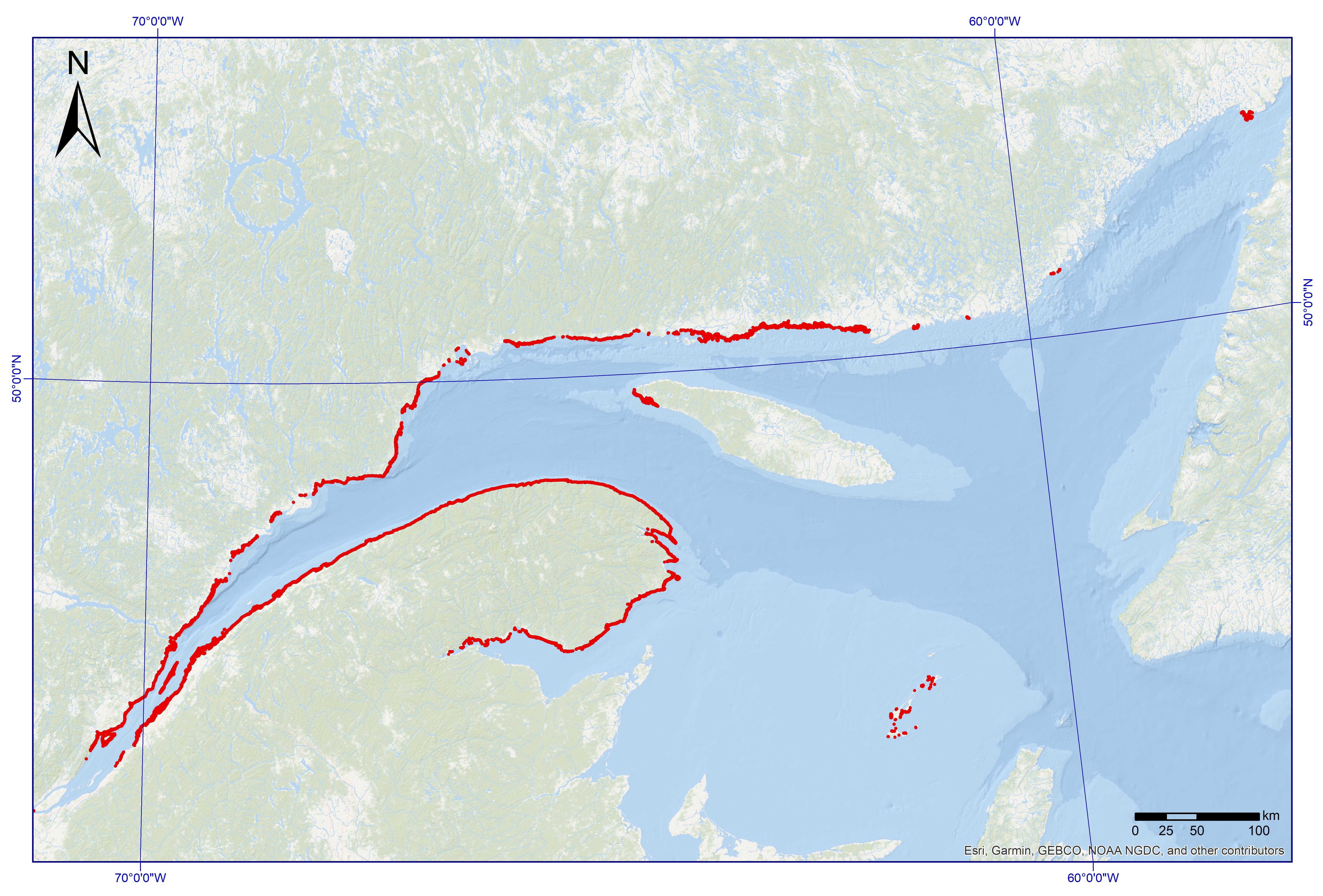
Macroalgae in the coastal zone of maritime Quebec
Macroalgae dominated areas with a vegetated cover above 25%, located in the coastal zone of the Estuary and the Gulf of St. Lawrence (Quebec)
This dataset was designed for Environment and Climate Change Canada's (ECCC) National Environmental Emergencies Center (NEEC) for oil spill preparedness and response. The polygons of this layer were selected from the surface geodatabase of coastal ecosystems from the UQAR-MPO project Mapping coastal ecosystems of the Estuary and Gulf of St. Lawrence. Are represented in this dataset exclusively the polygons whose plant dominance corresponds to a class of macroalgae and presenting a semi-vegetated (25-75%) or vegetated (75-100%) cover. The study area includes all of the estuarine and maritime coasts of Quebec, with the exception of certain sectors, including most of the Lower North Shore and Anticosti Island, with the exception of villages of Kegaska, la Romaine, Chevery, Blanc-Sablon and Port-Menier. Some islands off the estuary and gulf coasts are part of the region covered, such as Île d'Orléans, Isle-aux-Coudres, Île Verte and Île Bonaventure.
The mapping of coastal ecosystems was carried out jointly by the Laboratory for Dynamics and Integrated Coastal Zone Management (LDGIZC) of the University of Quebec at Rimouski as part of the Coastal Resilience Project (https: //ldgizc.uqar.ca/Web/projets/projet-resilience-cotiere) funded by the MELCC; and by the Fisheries and Oceans Canada team, as part of its Integrated marine response planning (IMRP) component of the Oceans Protection Plan (OPP),with the objective of updating the Marine Oil Spill Preparedness and Response Regime of Canada. The master geodatabase of coastal ecosystems is hosted and distributed by UQAR on their SIGEC-Web mapping platform: https://ldgizc.uqar.ca/Web/sigecweb
The macroalgae characterization was mainly carried out from the photo-interpretation of RGBI aerial photos acquired by the DFO (2015-2022) and oblique helicopter photos acquired by UQAR in 2017. Data from 3155 sampling stations, conducted aboard small boats during DFO field campaigns (2017-2023) were used to detail the nature of algal communities and validate the photo-interpretation.
Credits
© UQAR-MPO (2025, Laboratoire de dynamique et de gestion intégrée des zones côtières, Pêches et Océans Canada)
Référence
Provencher-Nolet, L., Paquette, L., Pitre, L.D., Grégoire, B. and Desjardins, C. 2024. Cartographie des macrophytes estuariens et marins du Québec. Rapp. Tech. Can. Sci. halieut. Aquat. 0000 : v + 99 p.
Grégoire, B., Pitre, L.D., Provencher-Nolet, L., Paquette, L. and Desjardins, C. 2024. Distribution d’organismes marins de la zone côtière peu profonde du Québec recensés par imagerie sous-marine de 2017 à 2021. Rapp. tech. can. sci. halieut. aquat. 0000 : v + 78 p.
Grégoire, B. 2022. Biodiversité du relevé côtier Planification pour une intervention environnementale intégrée dans l’estuaire et le golfe du Saint-Laurent (2017–2021). Observatoire global du Saint-Laurent. [Jeu de données]
Jobin, A., Marquis, G., Provencher-Nolet, L., Gabaj Castrillo. M. J., Trubiano C., Drouet, M., Eustache-Létourneau, D., Drejza, S. Fraser, C. Marie, G. et P. Bernatchez (2021) Cartographie des écosystèmes côtiers du Québec maritime — Rapport méthodologique. Chaire de recherche en géoscience côtière, Laboratoire de dynamique et de gestion intégrée des zones côtières, Université du Québec à Rimouski. Rapport remis au ministère de l’Environnement et de la Lutte contre les changements climatiques, septembre 2021, 98 p.
Simple
- Date ( RI_367 )
- 2023-05-04
- Date ( RI_366 )
- 2023-05-04
- Status
- completed; complété RI_593
- Maintenance and update frequency
- asNeeded; auBesoin RI_540
- Keywords ( RI_528 )
-
- Quebec
- Gulf of St. Lawrence
- Estuary of St. Lawrence
- Macroalgae
- Algae
- Seaweed
- Kelp
- Fucus
- Thésaurus des sujets de base du gouvernement du Canada Government of Canada Core Subject Thesaurus ( RI_528 )
-
- Aquatic ecosystems
- Aquatic wildlife
- Classification
- unclassified; nonClassifié RI_484
- Use limitation
- Open Government Licence - Canada (http://open.canada.ca/en/open-government-licence-canada)
- Access constraints
- license; licence RI_606
- Use constraints
- license; licence RI_606
- Spatial representation type
- grid; grille RI_636
- Metadata language
- eng; CAN
- Metadata language
- fre
- Topic category
-
- Environment
- Oceans
- Begin date
- 2015
- End date
- 2023
))
- Reference system identifier
- https://www.epsg.io / EPSG:4269
- Distribution format
-
-
SHP
(
1
)
-
SHP
(
1
)
- OnLine resource
-
Parent project publication
(
HTTPS
)
Supporting Document;HTML;eng,fra
- OnLine resource
-
Macroalgae of the coastal zone dataset
(
HTTPS
)
Dataset;SHP;eng,fra
- OnLine resource
-
Data Dictionary
(
HTTPS
)
Supporting Document;CSV;eng,fra
- OnLine resource
-
Vocabulary dictionnary
(
HTTPS
)
Supporting Document;CSV;eng,fra
- OnLine resource
-
Macroalgae in the coastal zone of maritime Quebec
(
ESRI REST: Map Service
)
Web Service;HTML;eng
- OnLine resource
-
Macroalgae in the coastal zone of maritime Quebec
(
ESRI REST: Map Service
)
Web Service;HTML;fra
- File identifier
- d094f525-1e85-4196-9bdb-0c4de9d8e234 XML
- Metadata language
- fra; CAN
- Character set
- utf8; utf8 RI_458
- Parent identifier
- Biological Sensitivity Mapping for Oil Spill Planning and Response, Quebec Region d8a6c6fd-76cc-4d68-a949-c4d80eb2f296
- Hierarchy level
- dataset; jeuDonnées RI_622
- Date stamp
- 2026-04-14T16:04:21.648879Z
- Metadata standard name
- North American Profile of ISO 19115:2003 - Geographic information - Metadata
- Metadata standard version
- CAN/CGSB-171.100-2009
Overviews
Spatial extent
Provided by
