The Canadian Radiological Monitoring Network – Monitoring Stations
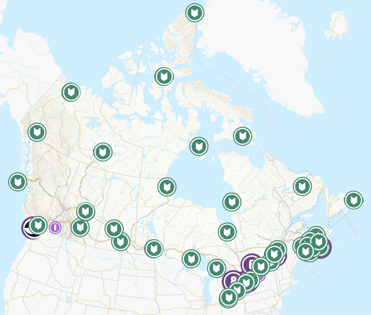
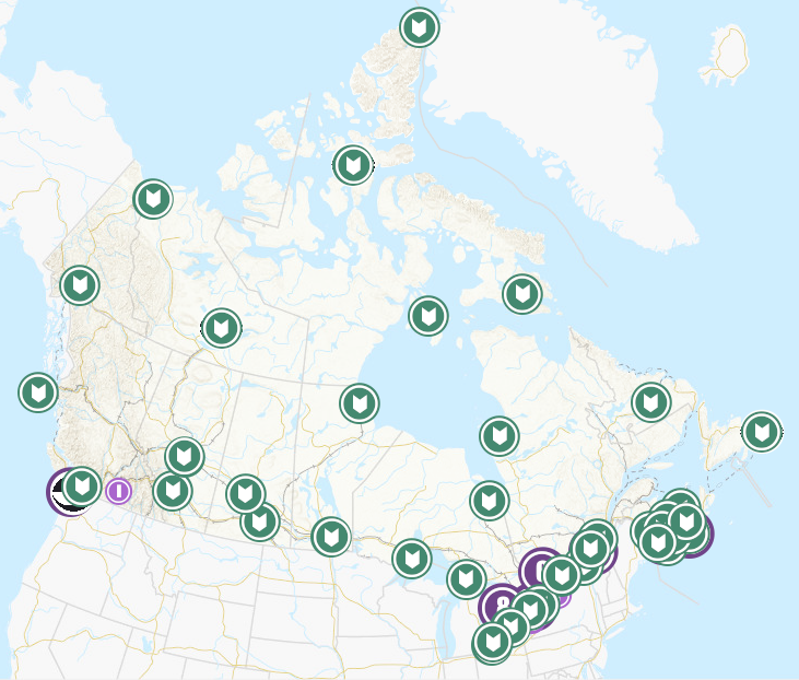
Health Canada routinely collects environmental samples for radioactivity analysis. The backbone of its monitoring comes from three separate networks: The Canadian Radiological Monitoring Network (CRMN), the Fixed Point Surveillance Network (FPS), and a Canadian contribution to the Comprehensive Nuclear-Test-Ban Treaty Organization (CTBTo). This dataset provides the approximate sampling location of the monitoring stations for each network.
CRMN is a national network that routinely collects air particulate, precipitation, external gamma dose, drinking water, atmospheric water vapour, and milk samples for radioactivity analysis. The CRMN has been operating since 1959, and is used to establish long-term trends in naturally occurring environmental radioactivity, nuclear weapons fallout, as well as radioactivity generated by other human activities including nuclear power generation and medical isotope production. Full datasets for the Canadian Radiological Monitoring Network are available on the Open Government Portal.
The Fixed Point Surveillance System (FPS) is an integrated network of radiation detectors providing terrestrial gamma radiation measurements in real time. The detectors are located in every province and territory of Canada with larger numbers in the vicinity of major Canadian nuclear facilities and ports where nuclear powered vessels sometimes harbour. Almost real time measurements are available on the EURDEP (EUropean Radiological Data Exchange Platform) website and monthly summaries are provided on the Health Canada website.
The Comprehensive Nuclear-Test-Ban Treaty (CTBT) is a universal arms control treaty that bans all States from conducting nuclear explosions in any environment (atmosphere, underground, underwater). Canada is a signatory to the United Nations CTBT. The Radiation Protection Bureau of Health Canada is responsible for four certified radionuclide monitoring stations and a certified radionuclide laboratory. Additional information on the CTBT is available on the CTBTo website.
The map shows the approximate sampling location for each monitoring station. Stations are found within the associated location range.
Simple
- Date ( RI_366 )
- 2020-11-20
- Date ( RI_367 )
- 2021-03-29
- Status
- onGoing; enContinue RI_596
- Maintenance and update frequency
- asNeeded; auBesoin RI_540
- Keywords ( RI_528 )
-
- environmental radioactivity monitoring
- radiation monitoring
- Government of Canada Core Subject Thesaurus Thésaurus des sujets de base du gouvernement du Canada ( RI_528 )
-
- Radioactive materials
- Health
- Radioactivity
- Use limitation
- Open Government Licence - Canada (http://open.canada.ca/en/open-government-licence-canada)
- Access constraints
- license; licence RI_606
- Use constraints
- license; licence RI_606
- Spatial representation type
- vector; vecteur RI_635
- Metadata language
- eng; CAN
- Metadata language
- fra; CAN
- Character set
- utf8; utf8 RI_458
- Topic category
-
- Health
- Environment
- Begin date
- 2014-09
- End date
- 2020-05
))
- Reference system identifier
- http://www.epsg-registry.org / EPSG:3978 /
- Distribution format
-
-
ESRI REST
(
10.7.1
)
-
WMS
(
1.3.0
)
-
ESRI REST
(
10.7.1
)
- OnLine resource
-
Monitoring Stations
(
HTTPS
)
Web Service;WMS;eng
- OnLine resource
-
Monitoring Stations
(
HTTPS
)
Web Service;WMS;fra
- OnLine resource
-
Network supporting infomation
(
HTTPS
)
Supporting Document;HTML;eng,fra
- OnLine resource
-
EURDEP website
(
HTTPS
)
Supporting Document;HTML;eng
- OnLine resource
-
CTBTo website
(
HTTPS
)
Supporting Document;HTML;eng
- OnLine resource
-
Monitoring Stations
(
ESRI REST: Map Server
)
Web Service;ESRI REST;eng
- OnLine resource
-
Monitoring Stations
(
ESRI REST: Map Server
)
Web Service;ESRI REST;fra
- File identifier
- d256b422-2834-40a2-9f0c-bd5fc32781b2 XML
- Metadata language
- fra; CAN
- Character set
- utf8; utf8 RI_458
- Hierarchy level
- dataset; jeuDonnées RI_622
- Date stamp
- 2025-11-12T12:07:37
- Metadata standard name
- North American Profile of ISO 19115:2003 - Geographic information - Metadata
- Metadata standard version
- CAN/CGSB-171.100-2009
Overviews


Spatial extent
))
Provided by

 Arctic SDI catalogue