 Arctic SDI catalogue
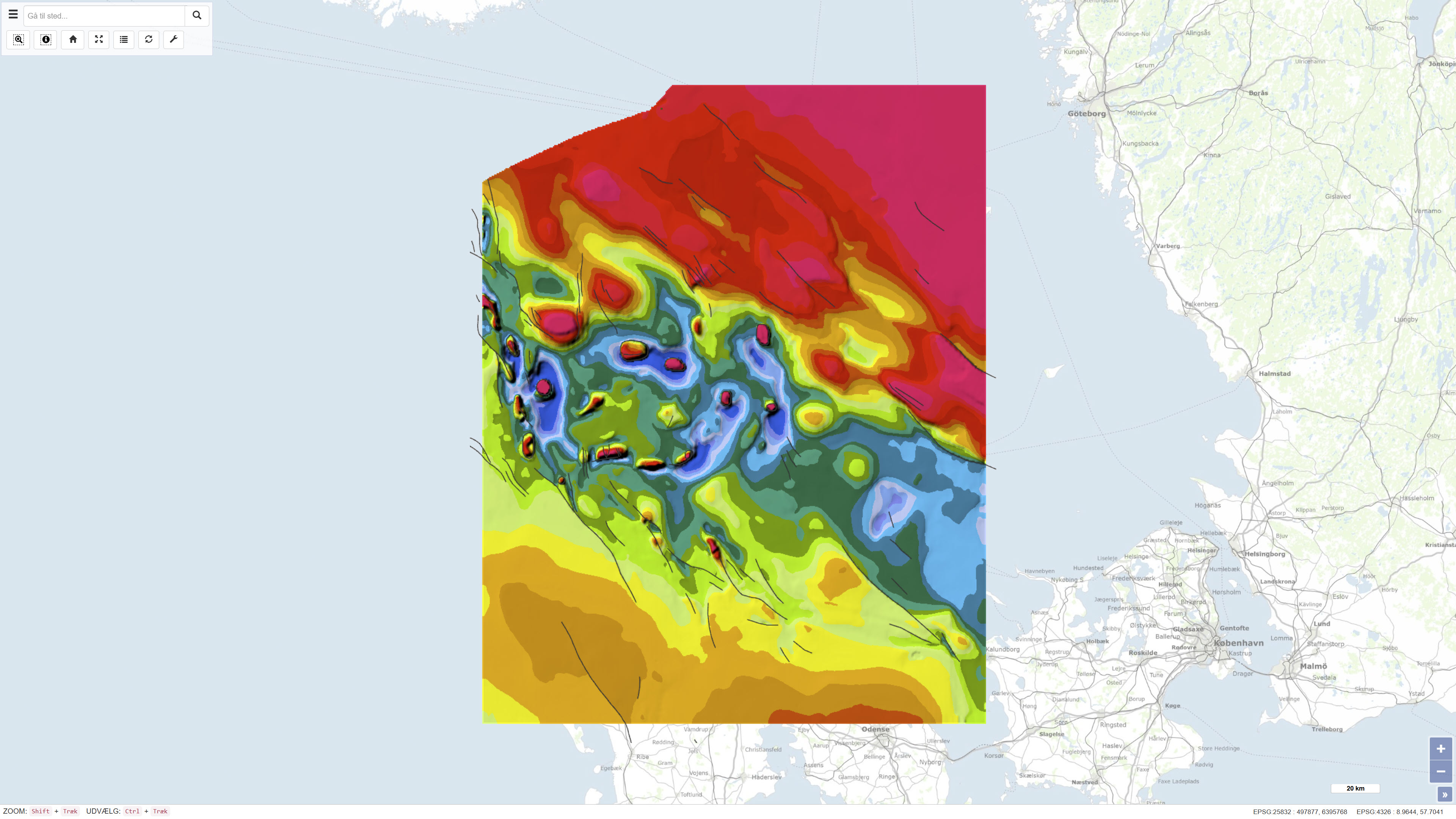
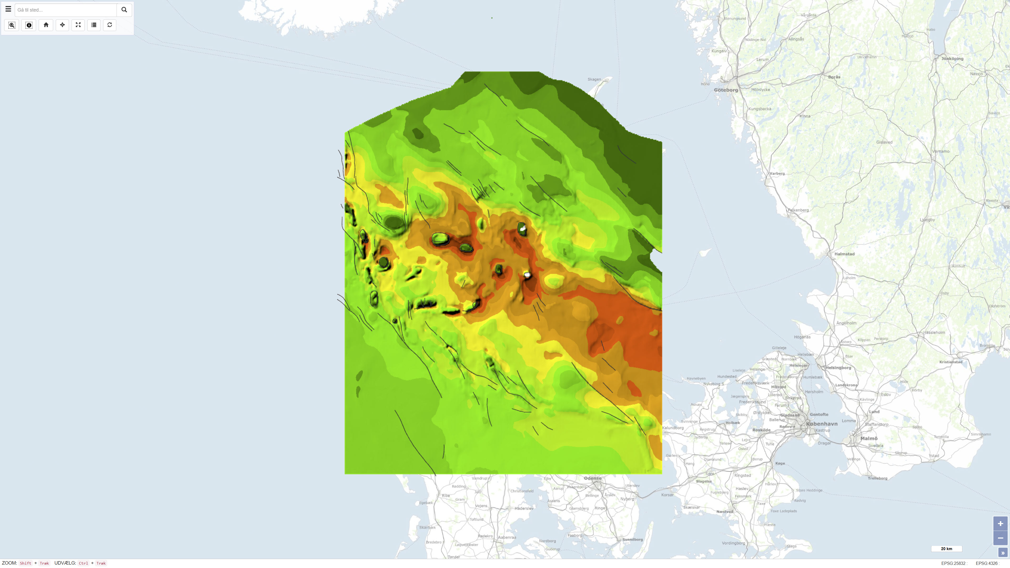
Geological Map of Denmark, 1:400.000 - The Danish Basin: Base Chalk and the Chalk Group
Simple
- Date ( Publication )
- 1993-01-01
- Identifier
- dk.geus / dk_danishbasin_basechalk_chalkgroup_400k
- Presentation form
- Digital map
- Purpose
- The purpose of the dataset is to document the regional structure and stratigraphic framework of the Base Chalk and the Chalk Group in the Danish Basin, thereby providing a basis for regional geological, structural and stratigraphic interpretation. The dataset is intended for use in geological analyses, research and planning-related applications.
- Status
- Completed
- Maintenance and update frequency
- As needed
- Keywords ( Theme )
-
- Dataset
- Geology
- Base Chalk
- Danish Basin
- Chalk Group
- Denmark
- Forskningsemner Forskningsemner ( Theme )
- Geografisk Geografisk ( Place )
- Access constraints
- Other restrictions
- Use constraints
- Other restrictions
- Other constraints
- CC BY-SA 4.0
- Other constraints
- Use of the dataset requires acknowledgement of the Geological Survey of Denmark and Greenland (GEUS) as the data source.
- Spatial representation type
- Vector
- Spatial representation type
- Grid
- Denominator
- 400000
- Metadata language
- Da
- Character set
- UTF8
- Topic category
-
- Geoscientific information
- Elevation
- Begin date
- 1975-01-01
- End date
- 1993-01-01
))
- Supplemental Information
- The dataset is a regional thematic map product at a scale of 1:400,000 and should be used with consideration of the map scale and level of generalisation. The map is part of the DGU map series and reflects the geological knowledge and data coverage available at the time of publication. The dataset consists of several thematic sub-maps that together form the complete presentation.
- Reference system identifier
- ETRS 89 / UTM 32N (EPSG:25832)
- Distribution format
-
-
WMS
(
)
-
REST
(
)
-
WMS
(
)
- OnLine resource
-
Interactive webmap
(
WWW:LINK-1.0-http--link
)
Interactive map displaying the dataset.
- OnLine resource
-
Geological map of Denmark, 1:400.000. The Danish Basin. "Basis Kalk" and Kalk Group
(
DOI
)
Official publication of the geological map of the Danish Basin showing the distribution of the Base Chalk and the Chalk Group. The map was published as DGU Map Series No. 29 in 1991 and provides a regional overview of chalk deposits within Denmark’s pre-Quaternary subsurface. The publication serves as a reference for geological, mineral resource, and hydrogeological studies.
- OnLine resource
-
DetDanskeBassin
(
ESRI:REST
)
ArcGIS REST Service
- OnLine resource
-
DB_BasisKalk_depth
(
OGC:WMS-1.3.0-http-get-capabilities
)
ArcGIS WMS Service
- Hierarchy level
- Dataset
- Statement
- The map was published as DGU Map Series no. 29 in 1993 and was produced based on regional interpretation of seismic data supplemented by information from deep onshore and offshore boreholes. The data basis includes both publicly available and proprietary seismic data acquired over several decades prior to publication. The seismic and borehole-based interpretations were used to compile regional maps of the depth to the Base Chalk as well as thickness maps of the Chalk Group. The dataset represents the geological interpretation available at the time of publication.
- File identifier
- d29eba56-12d2-4cf7-bf81-63a5a0882723 XML
- Metadata language
- Danskda
- Character set
- UTF8
- Hierarchy level
- Dataset
- Date stamp
- 2026-03-20T14:17:06.926373Z
- Metadata standard name
- ISO 19115:2003/19139
- Metadata standard version
- 1.0
Overviews
Spatial extent
Provided by
