 Arctic SDI catalogue
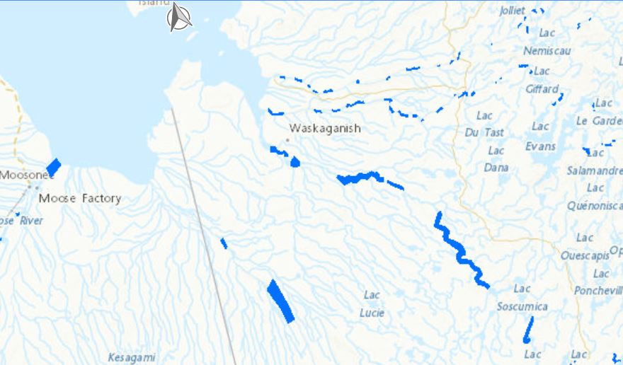
Dataset of Open Water Areas in River Ice for Provinces of Manitoba, Ontario, Quebec, and the Maritimes - Potential Locations for River Hydrokinetic Energy Extraction Identified Through Optical Satellite Imagery
Locations of open water within river ice in Manitoba, Ontario, Quebec, and the Maritimes were discerned manually using publicly accessible optical satellite images spanning from 2013 to 2020. This initial effort has led to a dataset pinpointing potential sites for river hydrokinetic energy initiatives.
A more comprehensive dataset encompassing the entirety of Canada’s major freezing rivers has also been developed entitled “Hydrokinetic Resource Mapping - Optical Satellite Imagery Analysis of Open Water Regions in Ice-Covered Canadian Rivers” and is available at (https://search.open.canada.ca/openmap/61b4e576-9f3a-49a1-9546-b29be14787a4).
Disclaimer:
The identification of open water locations within river ice in Manitoba, Ontario, Quebec, and the Maritimes, as described, was conducted manually through the analysis of publicly available optical satellite images. This dataset is subject to the following limitations:
1- The manual identification method may introduce potential human error and subjectivity within the dataset.
2- The publicly accessible satellite images employed may not provide fully comprehensive or entirely accurate representations of the actual conditions in the identified locations due to image resolution constraints, cloud cover, or atmospheric interference.
This dataset is intended for preliminary assessment and should not be the sole basis for making critical decisions or investments related to hydrokinetic energy projects. Further validation and in-depth analysis are strongly recommended, and users should conduct their own due diligence and additional research to verify the data accuracy and relevance for specific applications.
By accessing and using this dataset, users acknowledge and accept these disclaimers. The providers of this dataset explicitly absolve themselves of any responsibility or liability for any consequences arising from the use, reliance upon, or interpretation of this dataset. Users are advised that their use of the dataset is at their own risk, and they assume full responsibility for any actions or decisions made based on the information contained therein. This disclaimer is in accordance with applicable laws and regulations, and by accessing or utilizing the dataset, users agree to release the providers of this dataset from any legal claims, damages, or liabilities that may arise from such use.
Simple
- Date ( RI_366 )
- 2022-03-31
- Date ( RI_367 )
- 2024-03-24
- Status
- onGoing; enContinue RI_596
- Maintenance and update frequency
- asNeeded; auBesoin RI_540
- Government of Canada Core Subject Thesaurus Thésaurus des sujets de base du gouvernement du Canada ( RI_528 )
-
- Remote sensing
- Renewable energy
- Rivers
- Renewable resources
- Community development
- Ice
- Energy
- Use limitation
- Open Government Licence - Canada (http://open.canada.ca/en/open-government-licence-canada)
- Access constraints
- license; licence RI_606
- Use constraints
- license; licence RI_606
- Spatial representation type
- vector; vecteur RI_635
- Metadata language
- eng; CAN
- Topic category
-
- Geoscientific information
))
- Begin date
- 2014-09-01
- End date
- 2017-03-31
- Reference system identifier
- http://www.epsg-registry.org / EPSG:3978
- Distribution format
-
-
FGDB/GDB
(
10.7
)
-
SHP
(
unknown
)
-
WMS
(
1.3.0
)
-
FGDB/GDB
(
10.7
)
- OnLine resource
-
Open water regions in freezing rivers - Manual Optical satellite imagery
(
ESRI REST: Map Server
)
Web Service;ESRI REST;fra
- OnLine resource
-
Open water regions in freezing river- Manual Optical satellite imagery
(
OGC:WMS
)
Web Service;WMS;fra
- OnLine resource
-
Open water regions in freezing rivers - Manual Optical satellite imagery
(
HTTPS
)
Dataset;FGDB/GDB;eng
- OnLine resource
-
Open water regions in freezing rivers - Manual Optical satellite imagery
(
HTTPS
)
Dataset;FGDB/GDB;fra
- OnLine resource
-
Open water regions in freezing rivers - Manual Optical satellite imagery
(
HTTPS
)
Dataset;SHP;eng
- OnLine resource
-
Open water regions in freezing rivers - Manual Optical satellite imagery
(
HTTPS
)
Dataset;SHP;fra
- OnLine resource
-
Open water regions in freezing rivers - Manual Optical satellite imagery
(
ESRI REST: Map Server
)
Web Service;ESRI REST;eng
- OnLine resource
-
Open water regions in freezing rivers - Manual Optical satellite imagery
(
OGC:WMS
)
Web Service;WMS;eng
- File identifier
- d9823004-29aa-40e2-aa47-9c54cf88c309 XML
- Metadata language
- eng; CAN
- Character set
- utf8; utf8 RI_458
- Parent identifier
- Hydrokinetic Resource Mapping - Optical Satellite Imagery Analysis of Open Water Regions in Ice-Covered Canadian Rivers 61b4e576-9f3a-49a1-9546-b29be14787a4
- Hierarchy level
- dataset; jeuDonnées RI_622
- Date stamp
- 2024-03-25T13:10:11
- Metadata standard name
- North American Profile of ISO 19115:2003 - Geographic information - Metadata
- Metadata standard version
- CAN/CGSB-171.100-2009
Overviews
Spatial extent
Provided by
