Saccess, ortokorrigerade kartriktiga scener
Saccess innehåller optiska satellitdata från 1970-tal,  1980-tal, millennieskiftet och 2005. Med  början 2007 uppdateras Saccess årligen med ett nytt rikstäckande dataset.  Data är motttagna under vegetationsperioden respektive  period, och har en geometrisk upplösning  på 10-30 meter. Undantaget är data från 1970-talet som har 80 meters  upplösning.
                  
                  Simple
- Alternate title
- Satellitbilder
- Date ( Revision )
- 2023
- Identifier
- e1176741-625d-4b6a-b9e4-5c7a41e99e7f
- Status
- On going
                          
                            
                            Originator


                                Lantmäteriet


026-651655
http://www.lantmateriet.se


                                Geodatasupport, Lantmäteriet
                              
                              ,
                              
                                
                                Gävle
                              
                              ,
                              
                                
                                80182
                              
                              ,
                              
                                
                                Sverige


                            026-633600
                            026-651655
http://www.lantmateriet.se
- Maintenance and update frequency
- Annually
- Access constraints
- Other restrictions
- Other constraints
- Immateriella rättigheter
- Use constraints
- Other restrictions
- Access constraints
- Other restrictions
- Other constraints
- Immateriella rättigheter - Upphovsrätt
- Spatial representation type
- Grid
- Distance
- 10 meter
- Metadata language
- sv
- Topic category
- 
                            - Imagery base maps earth cover
 
- Environment description
- MetadataEditor=Geodata.Sverige.ExtJSEditor_1.0
- Description
- Satellitdata som täcker hela Sverige från 70-talet och framåt.
- Geographic identifier
- Sverige
                            
                            N


                            S


                            E


                            W
                          
                          )) 
                        - Begin date
- 1976
Vertical extent
- Minimum value
- -100
- Maximum value
- 2200
- Reference system identifier
- EPSG / http://www.opengis.net/def/crs/EPSG/0/3006
Distributor
- Name
- TIFF
- Version
- X.X
- Name
- GeoTIFF
- Version
- X.X
- Name
- BIL
- Version
- X.X
- Name
- BIP
- Version
- X.X
- Name
- BSQ
- Version
- X.X
- OnLine resource
- 


                                    Saccess
                                  
                                
                                (


                                    HTTP:Nedladdning
                                  
                                
                                )
                                Tjänsten Saccess för att ladda ned satellitbilder. 
- OnLine resource
- 


                                    Lantmäteriets webbsida
                                  
                                
                                (


                                    HTTP:Information:Produktspecifikation
                                  
                                
                                )
                                Mer information om produkten finns att hämta på Lantmäteriets webbsida. 
- Hierarchy level
- Series
Conformance result
- Date ( Publication )
- 2010-12-08
- Explanation
- https://www.geodata.se/globalassets/dokumentarkiv/regelverk/inspire/ir_interoperabilitet.pdf
- Pass
- Yes
Conformance result
- Date ( Publication )
- 2010-12-08
- Explanation
- https://www.geodata.se/globalassets/dokumentarkiv/regelverk/inspire/ir_interoperabilitet.pdf
- Pass
- Yes
Conformance result
- Date ( Publication )
- 2010-12-08
- Explanation
- https://www.geodata.se/globalassets/dokumentarkiv/regelverk/inspire/ir_interoperabilitet.pdf
- Pass
- Yes
- Statement
- Saccess innehåller optiska satellitdata från 1970-tal, 1980-tal, millennieskiftet och 2005. Med början 2007 uppdateras Saccess årligen med ett nytt rikstäckande dataset. Data är mottagna under vegetationsperioden respektive period, och har en geometrisk upplösning på 10-30 meter. Undantaget är data från 1970-talet som har 80 meter upplösning.
- File identifier
- da3e5412-e9e8-431d-a7a0-f7d70403f426 XML
- Metadata language
- sv
- Hierarchy level
- Series
- Date stamp
- 2024-06-03T12:50:31
- Metadata standard name
- SS-EN-ISO-19115:2005-NMDP 4.0
- Metadata standard version
- 4.0
                          
                            
                            Point of contact


                                Lantmäteriet


026-651655
http://www.lantmateriet.se


                                Geodatasupport, Lantmäteriet
                              
                              ,
                              
                                
                                Gävle
                              
                              ,
                              
                                
                                80182
                              
                              ,
                              
                                
                                Sverige


                            026-633600
                            026-651655
http://www.lantmateriet.se
Overviews
 
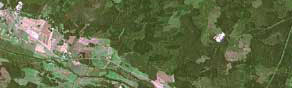
                  Mosaik med "naturliga" färger.
                Spatial extent
                      
                      N


                      S


                      E


                      W
                    
                    )) 
                  Provided by
 
                Associated resources
Not available
                 Arctic SDI catalogue
                  Arctic SDI catalogue