 Arctic SDI catalogue
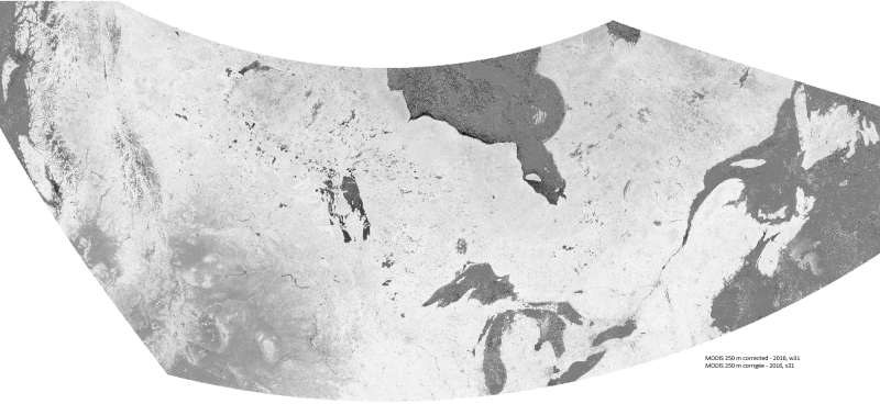
Corrected representation of the NDVI using historical MODIS satellite images (250 m resolution) from 2000 to present
The cloud-corrected NDVI data extracted from historical MODIS satellite images at 250 metre resolution provides reliable, objective, and timely information on the state of vegetation throughout Canada and the northern United States. The methodology applied to the images has remained the same as for the program formerly known as the Crop Condition Assessment Program (CCAP).
Since the 2000 growing season, Statistics Canada has been processing and compiling MODerate-resolution Imaging Spectoradiometer (MODIS) data (250 metre resolution). The Multi-Spectral Instrument (MSI) captures two spectral bands (red and infrared) that have proven to be extremely useful to produce the Normalized Difference Vegetation Index (NDVI) utilized for vegetation monitoring. The original NDVI image composites were produced by Agriculture and Agri-Food Canada (link to original data in the resources section). Additional computations were completed by Statistics Canada to remove the effects of residual clouds and to calculate and extract the NDVI by geographic region.
This dataset provides access to the MODIS images from 2000 to present in GeoTIFF format and covers the crop area during the growing season (Julian weeks 15 to 37; mid-April to mid-September). It also provides access to a database that contains the statistical NDVI by geographic regions (Townships, Census Consolidated Subdivisions (CCS), Census Divisions (CD) and Census Agricultural Regions (CAR)) and agricultural masks (Agriculture (AGR), Crop (CROP) and Pasture (PAS)).
Simple
- Date ( RI_367 )
- 2019-02
- Date ( RI_366 )
- 2019
1-514-282-9350
- Hours of service
- Monday to Friday (except holidays) from 8:30 to 4:30 pm
- Status
- completed; complété RI_593
- Maintenance and update frequency
- asNeeded; auBesoin RI_540
- Keywords ( RI_528 )
-
- Agriculture
- Satellite images
- MODIS
- NDVI
- growing season
- Resolution
- CCAP
- Government of Canada Core Subject Thesaurus Thésaurus des sujets de base du gouvernement du Canada ( RI_528 )
-
- Plants
- Agricultural assistance
- Agriculture
- Satellite imagery
- Agriculture statistics
- Use limitation
- Open Government Licence - Canada (http://open.canada.ca/en/open-government-licence-canada)
- Access constraints
- license; licence RI_606
- Use constraints
- license; licence RI_606
- Spatial representation type
- grid; grille RI_636
- Metadata language
- fra
- Metadata language
- eng
- Character set
- utf8; utf8 RI_458
- Topic category
-
- Farming
- Begin date
- 2000
- End date
- 2024
))
- Reference system identifier
- http://www.epsg-registry.org / EPSG:3978 /
- Distribution format
-
-
GeoTIF
(
1
)
-
GeoTIF
(
1
)
1-514-283-9350
- Hours of service
- Monday to Friday (except holidays) from 8:30 to 4:30 pm
- OnLine resource
-
Satellite image data processing at Statistics Canada for the Crop Condition Assessment Program (CCAP) - ENG
(
HTTPS
)
Supporting Document;HTML;eng
- OnLine resource
-
Satellite image data processing at Statistics Canada for the Crop Condition Assessment Program (CCAP) - FRE
(
HTTPS
)
Supporting Document;HTML;fra
- OnLine resource
-
Historical 250m database
(
FTP
)
Dataset;other;zxx
- OnLine resource
-
Crop Condition Assessment Program (CCAP) Web Application - FRE
(
HTTPS
)
Application;HTML;fra
- OnLine resource
-
Crop Condition Assessment Program (CCAP) Web Application - ENG
(
HTTPS
)
Application;HTML;eng
- OnLine resource
-
Equivalence between the images bands and the Julian weeks
(
HTTPS
)
Supporting Document;XLSX;eng,fra
- OnLine resource
-
Compressed Files Per Year (download directory)
(
HTTP
)
Dataset;ZIP;zxx
- OnLine resource
-
AAFC - Weekly Best-Quality Maximum NDVI Anomalies
(
HTTPS
)
Dataset;HTML;eng,fra
- File identifier
- dc700f75-19d8-4913-9846-78615ca93784 XML
- Metadata language
- fra; CAN
- Character set
- utf8; utf8 RI_458
- Hierarchy level
- dataset; jeuDonnées RI_622
- Date stamp
- 2025-01-09T09:29:00
- Metadata standard name
- North American Profile of ISO 19115:2003 - Geographic information - Metadata
- Metadata standard version
- CAN/CGSB-171.100-2009
1-514-282-9350
- Hours of service
- Monday to Friday (except holidays) from 8:30 to 4:30 pm
Overviews
Spatial extent
Provided by
