 Arctic SDI catalogue
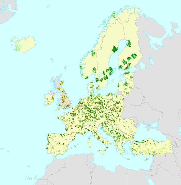
Urban Atlas Land Cover/Land Use 2012 (vector), Europe, 6-yearly, Jan. 2021
The European Urban Atlas provides reliable, inter-comparable, high-resolution land use and land cover data for 785 Functional Urban Area (FUA) for the 2012 reference year in EEA38 countries (EU, EFTA and Western Balkan countries as well as Türkiye) and United Kingdom. The spatial data can be downloaded together with a map for each FUA covered and a report with the metadata for the respective area.
Urban Atlas is a joint initiative of the Commission Directorate-General for Regional and Urban Policy and the Directorate-General for Defence Industry and Space (DEFIS) in the frame of the EU Copernicus programme, with the support of the European Space Agency and the European Environment Agency.
Simple
- Date ( Creation )
- 2016-08-04
- Date ( Publication )
- 2016-08-04
- Date ( Revision )
- 2021-01-20
- Edition
- 02.01
- Identifier
- copernicus_v_3035_10_m_ua-2012_p_2011-2013_v02_r01
- Identifier
- DAT-190-en
- Unique resource identifier
- 10.2909/debc1869-a4a2-4611-ae95-daeefce23490
- Maintenance and update frequency
- Continual
- GEMET - INSPIRE themes, version 1.0 ( Theme )
-
- Land use
- Keywords
-
- Continents, countries, sea regions of the world. ( Place )
-
- EEA38 (from 2020)
- United Kingdom
- Keywords
-
- GEMET ( Theme )
-
- land cover
- landscape alteration
- land use
- urban area
- Spatial scope ( Theme )
- EEA topics ( Theme )
-
- Land use
- EEA Management Plan ( Theme )
-
- 2018 3.6.2
- Access constraints
- Other restrictions
- Other constraints
- no limitations to public access
- Use constraints
- Other restrictions
- Other constraints
-
The Copernicus component is governed by Regulation (EU) No 2021/696 of the European Parliament and of the Council of 28 April 2021 establishing the Union Space Programme and the European Union Agency for the Space Programme and repealing Regulations (EU) No 912/2010, (EU) No 1285/2013 and (EU) No 377/2014 and Decision No 541/2014/EU. Within the Copernicus component, a portfolio of land monitoring activities has been delegated by the European Union to the European Environment Agency (EEA) and the DG Joint Research Centre of the European Commission.
The Copernicus land monitoring products and services are made available on a principle of full, open and free access, as established by the Commission Delegated Regulation (EU) No 1159/2013 of 12 July 2013.
Free, full and open access to the products and services of the Copernicus Land Monitoring Service is made on the conditions that:
1. When distributing or communicating Copernicus Land Monitoring Service products and services (data, software scripts, web services, user and methodological documentation and similar) to the public, users shall inform the public of the source of these products and services.
2. Where the Copernicus Land Monitoring Service products and services have been adapted or modified by the user, the user shall clearly state this.
3. Users shall make sure not to convey the impression to the public that the user's activities are officially endorsed by the European Union.
- Aggregate Datasetindentifier
- 2f86b35b-4c09-4aa4-80eb-e29426ac065b
- Association Type
- revisionOf
- Spatial representation type
- vector Vector
- Distance
- 10 m
- Metadata language
- en
- Character set
- utf8 UTF8
- Topic category
-
- Environment
- Imagery base maps earth cover
- Begin date
- 2011-01-01
- End date
- 2013-12-31
))
- Supplemental Information
- Spatial Resolution information: The Minimum Mapping Width is 10 m
- Unique resource identifier
- EPSG:3035
- Distribution format
-
-
SHP
(
1.1
)
-
Geopackage
(
)
-
SHP
(
1.1
)
- OnLine resource
- https://image.discomap.eea.europa.eu/arcgis/rest/services/UrbanAtlas/UA_UrbanAtlas_2012/MapServer ( ESRI:REST )
- OnLine resource
- https://doi.org/10.2909/debc1869-a4a2-4611-ae95-daeefce23490 ( DOI )
- OnLine resource
- UrbanAtlas_2012 ( OGC:WMS )
- OnLine resource
-
CLMS Website
(
WWW:DOWNLOAD
)
Download (requires authentication)
- OnLine resource
- Product Information & Technical Documentation ( WWW:LINK )
- Hierarchy level
- Dataset
Conformance result
- Date ( Publication )
- 2010-12-08
- Explanation
- See the referenced specification
- Statement
-
The Urban Atlas is mainly based on the combination of (statistical) image classification and visual interpretation of Very High Resolution (VHR) satellite imagery. Multispectral SPOT 5 & 6 and Formosat-2 pan-sharpened imagery with a 2 to 2.5m spatial resolution is used as input data. The built-up classes are combined with density information on the level of sealed soil derived from the High Resolution Layer imperviousness to provide more detail in the density of the urban fabric. Finally, the Urban Atlas product is complemented and enriched with functional information (road network, services, utilities etc…) using ancillary data sources such as local city maps or online map services.
During the mapping campaign for the update of Urban Atlas 2018, the LCLU status product of Urban Atlas 2012 was revised.
Version 021 marks the new revised FUAs with the population estimates added as attribute Pop2012.
Typology:
11100 Continuous Urban Fabric (S.L. > 80%)
11210 Discontinuous Dense Urban Fabric (S.L. : 50% - 80%)
11220 Discontinuous Medium Density Urban Fabric (S.L. : 30% - 50%)
11230 Discontinuous Low Density Urban Fabric (S.L. : 10% - 30%)
11240 Discontinuous Very Low Density Urban Fabric (S.L. < 10%)
11300 Isolated Structures
12100 Industrial, commercial, public, military and private units
12210 Fast transit roads and associated land
12220 Other roads and associated land
12230 Railways and associated land
12300 Port areas
12400 Airports
13100 Mineral extraction and dump sites
13300 Construction sites
13400 Land without current use
14100 Green urban areas
14200 Sports and leisure facilities
21000 Arable land (annual crops)
22000 Permanent crops (vineyards, fruit trees, olive groves)
23000 Pastures
24000 Complex and mixed cultivation patterns
25000 Orchards at the fringe of urban classes
31000 Forests
32000 Herbaceous vegetation associations (natural grassland, moors...)
33000 Open spaces with little or no vegetations (beaches, dunes, bare rocks, glaciers)
40000 Wetland
50000 Water bodies
External Quality control realized by IGNFI.
- File identifier
- debc1869-a4a2-4611-ae95-daeefce23490 XML
- Metadata language
- en
- Character set
- UTF8
- Hierarchy level
- Dataset
- Date stamp
- 2025-10-09T11:18:55.647392Z
- Metadata standard name
- ISO 19115/19139
- Metadata standard version
- 1.0
Overviews
Spatial extent
Provided by
