 Arctic SDI catalogue
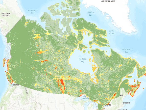
Archived - Flood Susceptibility Index (FSI)
This dataset is archived, please refer to:
- [Collection – Flood Susceptibility Mapping]( https://open.canada.ca/data/en/dataset/1074f781-85d3-4c86-86cb-fd1c339197dc ) for the new release.
This national map of flood susceptibility or flood prone areas is based on patterns of historic flood events as predicted by an ensemble machine learning model.
The recommended use is national, provincial or regional scale and can be used as a guide for identifying areas for further investigation. The Flood Susceptibility Index (FSI) Dataset, while processed and available at 30m cell size, is not recommended for use at the pixel or street level, given the uncertainty in the modelling process and the variability of results as discussed in https://www.mdpi.com/2673-4931/25/1/18 .
For additional details on the methods, tests, models and datasets used to generate this data layer, please see https://geoscan.nrcan.gc.ca/starweb/geoscan/servlet.starweb?path=geoscan/fulle.web&search1=R=329493
Simple
- Date ( RI_367 )
- 2022-06-15
- Date ( RI_366 )
- 2015-07-01
- Status
- completed; complété RI_593
- Maintenance and update frequency
- irregular; irrégulier RI_541
- Keywords ( RI_528 )
-
- Flood prone, Flood susceptibility, Hazard identification, Flood priority
- Government of Canada Core Subject Thesaurus Thésaurus des sujets de base du gouvernement du Canada ( RI_528 )
-
- Floods
- Earth sciences
- Surface water
- Hydrology
- Water management
- Use limitation
- Open Government Licence - Canada (http://open.canada.ca/en/open-government-licence-canada)
- Access constraints
- license; licence RI_606
- Use constraints
- license; licence RI_606
- Spatial representation type
- grid; grille RI_636
- Metadata language
- eng; CAN
- Metadata language
- fra; CAN
- Character set
- utf8; utf8 RI_458
- Topic category
-
- Geoscientific information
- Climatology, meteorology, atmosphere
- Environment
- Inland waters
- Begin date
- 2015-01-01
))
- Reference system identifier
- https://www.epsg-registry.org / EPSG:3979 /
- Distribution format
-
-
WMS
(
1.3.0
)
-
WCS
(
1.3.0
)
-
TIFF
(
Unknown
)
-
Web App
(
N/A
)
-
WMS
(
1.3.0
)
- OnLine resource
-
Accessing the Impact of Meteorological Variables on Machine Learning Flood Susceptibility Mapping
(
HTTPS
)
Supporting Document;PDF;eng
- OnLine resource
-
Prediction and Classification of Flood Susceptibility Across Canada
(
HTTPS
)
Supporting Document;PDF;eng,fra
- OnLine resource
-
Flood Susceptibility
(
HTTPS
)
Web Service;WCS;eng,fra
- OnLine resource
-
Flood Susceptibility Class
(
HTTPS
)
Dataset;TIFF;eng,fra
- OnLine resource
-
Flood Susceptibility Index
(
HTTPS
)
Dataset;TIFF;eng,fra
- OnLine resource
-
Accessing the Impact of Meteorological Variables on Machine Learning Flood Susceptibility Mapping
(
HTTPS
)
Supporting Document;PDF;fra
- OnLine resource
-
Flood Susceptibility
(
OGC:WMS
)
Web Service;WMS;eng
- OnLine resource
-
Flood Susceptibility
(
OGC:WMS
)
Web Service;WMS;fra
- OnLine resource
-
Web Viewer of Flood Susceptibility
(
HTTPS
)
Application;Web App;eng
- OnLine resource
-
Web Viewer of Flood Susceptibility
(
HTTPS
)
Application;Web App;fra
- File identifier
- df106e11-4cee-425d-bd38-7e51ac674128 XML
- Metadata language
- eng; CAN
- Character set
- utf8; utf8 RI_458
- Hierarchy level
- dataset; jeuDonnées RI_622
- Date stamp
- 2026-05-06T15:07:34
- Metadata standard name
- North American Profile of ISO 19115:2003 - Geographic information - Metadata
- Metadata standard version
- CAN/CGSB-171.100-2009
Overviews
Spatial extent
Provided by
