 Arctic SDI catalogue
Ortofoto historiska Visning
Produkten innehåller historiska ortofoton (ortogonalprojicerade flygbilder, skalriktiga i markytan) i sv/v, färg (RGB) och infrarött (IR) från åren 1949 – 2005, uppdelade i olika lager. Produkten uppfyller kraven för EU-direktivet Inspire.
Simple
Identification info
- Alternate title
- Historical orthophoto View Service
- Date ( Publication )
- 2018-03-20
- Date ( Revision )
- 2025-04-09
- Maintenance and update frequency
- Continual
- Maintenance note
- Produkten uppdateras kontinuerligt med nya ortofoton allt eftersom de framställs.
- GEMET - INSPIRE themes, version 1.0 ( Theme )
- Geografisk utsträckning ( Theme )
- Ämnesområde ( Theme )
-
- Arealtäckande bilder och bakgrundskartor
- Initiativ ( Theme )
-
- Inspire
- Öppna data
- Use limitation
- no condition apply
- Access constraints
- Other restrictions
- Other constraints
- Inga begränsningar för allmänhetens tillgång
- Access constraints
- Other restrictions
- Other constraints
- Ingen begränsning
- Use constraints
- Other restrictions
- Other constraints
- Historiska ortofoton tillhandahålls utan licensavgift och med förenklade användningsvillkor. Produkten tillhör Lantmäteriets öppna data.
- Service Type
- view
- Description
- Hela Sverige
N
S
E
W
))
Vertical extent
Coupled Resource
- Operation Name
- GetCapabilities
- Identifier
- c4c38adc-1e35-4054-a2f5-d6e77a95bd3c
Contains Operations
No information provided.
- Operates On
- Reference system identifier
- EPSG / http://www.opengis.net/def/crs/EPSG/0/4326
- Reference system identifier
- EPSG / http://www.opengis.net/def/crs/EPSG/0/3035
- Reference system identifier
- EPSG / http://www.opengis.net/def/crs/EPSG/0/3034
- Reference system identifier
- EPSG / http://www.opengis.net/def/crs/EPSG/0/3044
- Reference system identifier
- EPSG / http://www.opengis.net/def/crs/EPSG/0/3045
- Reference system identifier
- EPSG / http://www.opengis.net/def/crs/EPSG/0/3857
- Reference system identifier
- EPSG / http://www.opengis.net/def/crs/EPSG/0/3007
- Reference system identifier
- EPSG / http://www.opengis.net/def/crs/EPSG/0/3006
- Reference system identifier
- EPSG / http://www.opengis.net/def/crs/EPSG/0/4258
- Reference system identifier
- EPSG / http://www.opengis.net/def/crs/EPSG/0/4619
- Reference system identifier
- EPSG / http://www.opengis.net/def/crs/EPSG/0/3035
- Reference system identifier
- EPSG / http://www.opengis.net/def/crs/EPSG/0/3046
- Reference system identifier
- EPSG / http://www.opengis.net/def/crs/EPSG/0/3047
- Reference system identifier
- EPSG / http://www.opengis.net/def/crs/EPSG/0/3021
- Reference system identifier
- EPSG / http://www.opengis.net/def/crs/EPSG/0/3010
- Reference system identifier
- EPSG / http://www.opengis.net/def/crs/EPSG/0/3014
- Reference system identifier
- EPSG / http://www.opengis.net/def/crs/EPSG/0/3011
- Reference system identifier
- EPSG / http://www.opengis.net/def/crs/EPSG/0/3015
- Reference system identifier
- EPSG / http://www.opengis.net/def/crs/EPSG/0/3016
- Reference system identifier
- EPSG / http://www.opengis.net/def/crs/EPSG/0/3017
- Reference system identifier
- EPSG / http://www.opengis.net/def/crs/EPSG/0/3018
- Reference system identifier
- EPSG / http://www.opengis.net/def/crs/EPSG/0/25832
- Reference system identifier
- EPSG / http://www.opengis.net/def/crs/EPSG/0/25833
- Reference system identifier
- EPSG / http://www.opengis.net/def/crs/EPSG/0/25834
- Reference system identifier
- EPSG / http://www.opengis.net/def/crs/EPSG/0/25835
- Reference system identifier
- EPSG / http://www.opengis.net/def/crs/EPSG/0/32632
- Reference system identifier
- EPSG / http://www.opengis.net/def/crs/EPSG/0/32633
- Reference system identifier
- EPSG / http://www.opengis.net/def/crs/EPSG/0/32634
- Reference system identifier
- EPSG / http://www.opengis.net/def/crs/EPSG/0/32635
Distributor
- OnLine resource
-
Produktdokumentation för Ortofoto historiska Visning
(
HTTP:Information
)
Produktdokumentation för Ortofoto historiska Visning
- OnLine resource
-
Åtkomstpunkt till Ortofoto historiska Visning
(
HTTP:OGC:WMS
)
Åtkomstpunkt till tjänsten Ortofoto historiska Visning (ordinarie åtkomstpunkt)
- Hierarchy level
- Service
Conformance result
- Date ( Publication )
- 2009-10-20
- Explanation
- Enligt ovanstående specifikation
- Pass
- Yes
- File identifier
- e04a0e7c-2c86-4931-a6f5-bab4091c8745 XML
- Metadata language
- sv
- Hierarchy level
- Service
- Date stamp
- 2026-06-15T16:11:45.175Z
- Metadata standard name
- SS-EN-ISO-19115:2005-NMDP 4.0
- Metadata standard version
- 4.0
Point of contact
Lantmäteriet
-
Geodatasupport
www.lantmateriet.se
Gävle
,
801 82
,
Sverige
026-63 36 00
www.lantmateriet.se
Overviews
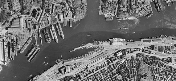
Historiska ortofoto Visning
Spatial extent
N
S
E
W
Provided by

Associated resources
Not available