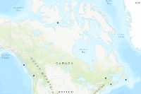
Cumulative Effects of Marine Shipping - Pilot areas
Launched in 2017, the Cumulative Effects of Marine Shipping (CEMS) initiative is part of Canada’s $1.5 billion Oceans Protection Plan, which is providing economic opportunities to Canadians today, while protecting our coasts and waterways for future generations. The Cumulative Effects of Marine Shipping initiative is another way that the Government of Canada is protecting our coasts and waterways.
As part of this initiative, Transport Canada is working with Indigenous partners and stakeholders in six pilot areas across Canada. Together, we are trying to understand the effects of marine shipping in various coastal areas. These pilot areas include:
- North Coast British Columbia
- South Coast British Columbia
- St. Lawrence and Saguenay Rivers, Quebec
- Bay of Fundy, New Brunswick and Nova Scotia
- Placentia Bay, Newfoundland
- Cambridge Bay, Nunavut
Simple
- Date ( RI_367 )
- 2021-09
- Date ( RI_366 )
- 2021-06
- Status
- completed; complété RI_593
- Maintenance and update frequency
- asNeeded; auBesoin RI_540
- Keywords
-
- Shipping
- Government of Canada Core Subject Thesaurus Thésaurus des sujets de base du gouvernement du Canada ( RI_528 )
-
- Transport
- Oceans
- Use limitation
- Open Government Licence - Canada (http://open.canada.ca/en/open-government-licence-canada)
- Access constraints
- licenseUnrestricted; licenceSansRestriction RI_610
- Use constraints
- licenseUnrestricted; licenceSansRestriction RI_610
- Spatial representation type
- vector; vecteur RI_635
- Metadata language
- eng
- Metadata language
- fra
- Topic category
-
- Transportation
- Oceans
- Begin date
- 2021-09-24
- End date
- 2021-09-24
))
- Reference system identifier
- http://www.epsg-registry.org / EPSG:3857 /
- Distribution format
-
-
ESRI REST
(
10.8.1
)
-
ESRI REST
(
10.8.1
)
- OnLine resource
-
Pilot Sites - Cumulative Effects of Marine Shipping
(
ESRI REST: Feature Service
)
Web Service;ESRI REST;eng
- OnLine resource
-
Pilot Sites - Cumulative Effects of Marine Shipping
(
ESRI REST: Feature Service
)
Web Service;ESRI REST;fra
- File identifier
- e218c8cb-5039-4706-b58f-d54c6c11a6fc XML
- Metadata language
- eng; CAN
- Character set
- utf8; utf8 RI_458
- Hierarchy level
- dataset; jeuDonnées RI_622
- Date stamp
- 2022-07-21T19:05:32
- Metadata standard name
- North American Profile of ISO 19115:2003 - Geographic information - Metadata
- Metadata standard version
- CAN/CGSB-171.100-2009
Overviews


Spatial extent
))
Provided by

 Arctic SDI catalogue