 Arctic SDI catalogue
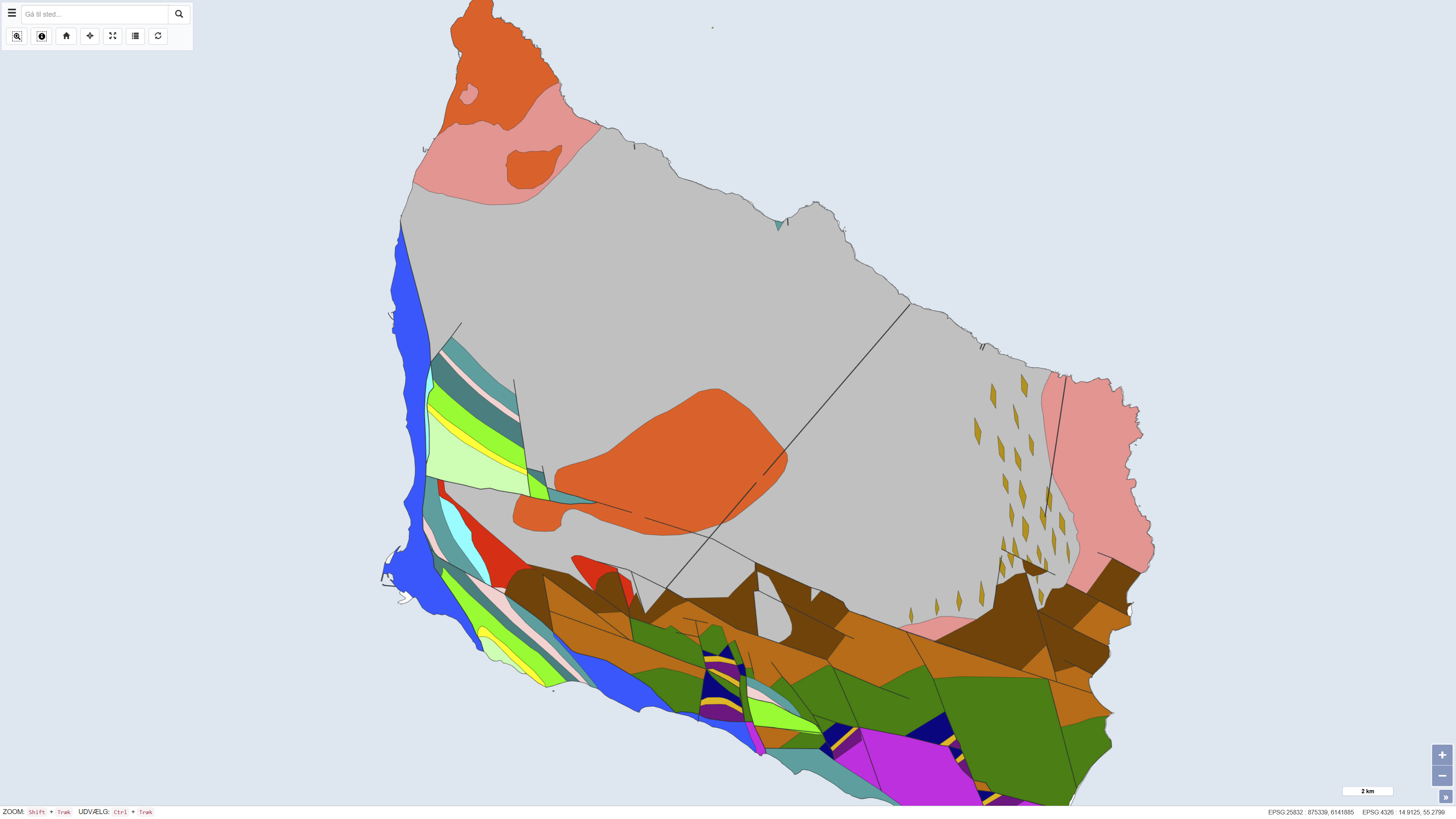
Pre-Quaternary surface of Bornholm
Simple
- Date ( Publication )
- 1977-01-01
- Identifier
- dk.geus / praekvartaeroverfladen_bornholm
- Presentation form
- Digital map
- Purpose
- The purpose of the dataset is to document and communicate the pre-Quaternary geological framework of Bornholm as a basis for regional geological understanding, research, and education. The map provides an integrated overview of pre-Quaternary structures and units and serves as a historical reference map.
- Status
- Completed
- Maintenance and update frequency
- As needed
- Keywords ( Theme )
-
- Dataset
- Geology
- Bornholm
- ArcGIS
- Pre-Quaternary
- Surface
- Forskningsemner Forskningsemner ( Theme )
- Geografisk Geografisk ( Place )
- Access constraints
- Other restrictions
- Use constraints
- Other restrictions
- Other constraints
- This dataset is based on material copyrighted by Varv journal (© 1992). GEUS is not the copyright holder of the original material. Use, redistribution or reproduction may be subject to copyright restrictions and requires permission from the rights holder. Users are responsible for ensuring compliance with applicable copyright legislation.
- Other constraints
- CC0 1.0
- Spatial representation type
- Vector
- Spatial representation type
- Grid
- Denominator
- 500000
- Metadata language
- Da
- Character set
- UTF8
- Topic category
-
- Geoscientific information
- Imagery base maps earth cover
- Begin date
- 1960-01-01
- End date
- 1977-01-01
))
- Supplemental Information
- The dataset represents a historical geological map reflecting the geological understanding at the time of publication. The map is not updated and should be used in conjunction with more recent geological maps, borehole data, and models where detailed or up-to-date interpretations are required.
- Reference system identifier
- ETRS 89 / UTM 32N (EPSG:25832)
- Distribution format
-
-
WMS
(
)
-
WMTS
(
)
-
REST
(
)
-
WMS
(
)
- OnLine resource
-
Download
(
WWW:DOWNLOAD-1.0-http--download
)
Download dataset from GEUS' Dataverse
- OnLine resource
-
Interactive webmap
(
WWW:LINK-1.0-http--link
)
Interactive map displaying the dataset.
- OnLine resource
-
Report
(
DOI
)
Search for publications by GEUS researchers in GEUS' Publications
- OnLine resource
-
Praekvartaer_Bornholm_Varv
(
ESRI:REST
)
ArcGIS REST Service
- OnLine resource
-
Prekvart_Bornholm
(
OGC:WMS-1.3.0-http-get-capabilities
)
ArcGIS WMS Service
- OnLine resource
-
Denmark_Praekvartaer_Bornholm_Varv
(
OGC:WMTS-1.0.0-http-get-capabilities
)
ArcGIS WMTS Service
- Hierarchy level
- Dataset
- Statement
- The map is based on geological mapping and interpretations carried out by Helge Gry in 1960 and 1969. The data foundation includes field observations, geological profiles, borehole information, and structural analyses representing the best available knowledge of Bornholm’s pre-Quaternary geology at the time. The map was editorially processed and published in VARV in 1977. The dataset is a historical product and is not subject to continuous updates.
- File identifier
- e591b1db-b052-4849-90a8-7b8acff7c451 XML
- Metadata language
- Danskda
- Character set
- UTF8
- Hierarchy level
- Dataset
- Date stamp
- 2026-03-20T10:34:27.90597Z
- Metadata standard name
- ISO 19115:2003/19139
- Metadata standard version
- 1.0
Overviews
Spatial extent
Provided by
