 Arctic SDI catalogue
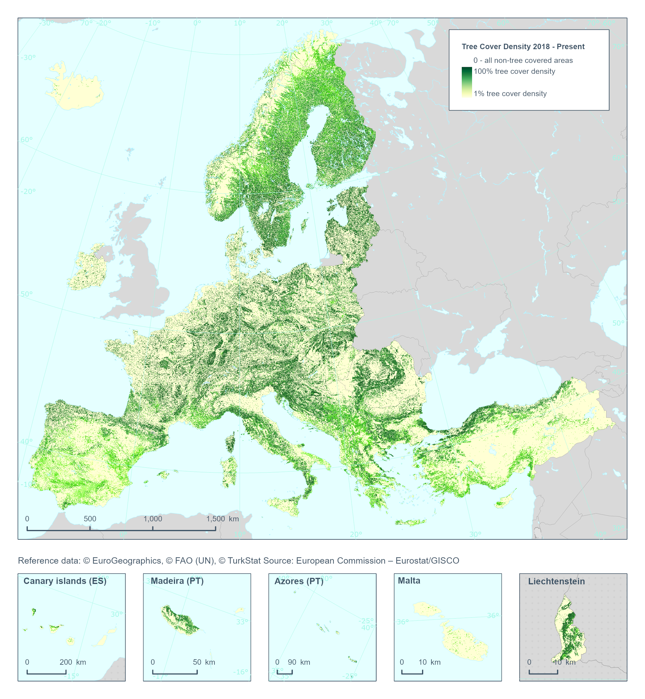
Tree Cover Density 2018 - Present (raster 10m), Europe, yearly, Nov. 2024
The High Resolution Layer Tree Cover Density (TCD) dataset provides information on the proportional crown coverage per pixel at 10 meter spatial resolution and ranges from 0% (all non-tree covered areas) to 100%, whereby Tree Cover Density is defined as the "vertical projection of tree crowns to a horizontal earth’s surface“.
This dataset is provided annually starting with 2018 in 10 meter rasters (fully conformant with the EEA reference grid) in 100 x 100 km tiles covering the EEA38 countries.
High Resolution Layer Tree Cover and Forest product is part of the European Union’s Copernicus Land Monitoring Service. Confidence layer available for the dataset.
This dataset includes data from the French Overseas Territories (DOMs).
Simple
- Date ( Creation )
- 2024-02-12
- Date ( Publication )
- 2024-12-01
- Edition
- 01.00
- Identifier
- copernicus_r_3035_10_m_tcd_p_2018-now_v01_r00
- Unique resource identifier
- 10.2909/e677441e-fb94-431c-b4f9-304f10e4dfd8
Point of contact
- Maintenance and update frequency
- As needed
- GEMET - INSPIRE themes, version 1.0 ( Theme )
- Keywords
-
- Continents, countries, sea regions of the world. ( Place )
-
- EEA38 (from 2020)
- Keywords
-
- GEMET ( Theme )
- Spatial scope ( Theme )
- EEA topics ( Theme )
- EEA Management Plan ( Theme )
-
- 2024 6.5.24
- Access constraints
- Other restrictions
- Other constraints
- no limitations to public access
- Use constraints
- Other restrictions
- Other constraints
-
The Copernicus component is governed by Regulation (EU) No 2021/696 of the European Parliament and of the Council of 28 April 2021 establishing the Union Space Programme and the European Union Agency for the Space Programme and repealing Regulations (EU) No 912/2010, (EU) No 1285/2013 and (EU) No 377/2014 and Decision No 541/2014/EU. Within the Copernicus component, a portfolio of land monitoring activities has been delegated by the European Union to the European Environment Agency (EEA) and the DG Joint Research Centre of the European Commission.
The Copernicus land monitoring products and services are made available on a principle of full, open and free access, as established by the Commission Delegated Regulation (EU) No 1159/2013 of 12 July 2013.
Free, full and open access to the products and services of the Copernicus Land Monitoring Service is made on the conditions that:
1. When distributing or communicating Copernicus Land Monitoring Service products and services (data, software scripts, web services, user and methodological documentation and similar) to the public, users shall inform the public of the source of these products and services.
2. Where the Copernicus Land Monitoring Service products and services have been adapted or modified by the user, the user shall clearly state this.
3. Users shall make sure not to convey the impression to the public that the user's activities are officially endorsed by the European Union.
- Spatial representation type
- grid Grid
- Distance
- 10 m
- Metadata language
- en
- Character set
- utf8 UTF8
- Topic category
-
- Environment
- Imagery base maps earth cover
))
- Begin date
- 2018-01-01
))
))
))
))
))
- Unique resource identifier
- EPSG:3035
- Unique resource identifier
- EPSG:32738
- Unique resource identifier
- EPSG:32740
- Unique resource identifier
- EPSG:32620
- Unique resource identifier
- EPSG:32622
- Distribution format
-
-
GTiff
(
)
-
GTiff
(
)
OnLine resource
- OnLine resource
-
WEkEO Portal
(
WWW:DOWNLOAD
)
Download (requires authentication)
- OnLine resource
-
CLMS Website
(
WWW:LINK-1.0-http--link
)
Product Information & Technical Documentation
- OnLine resource
-
HRL_TCF:TCD_S2018
(
OGC:WMS
)
CLMS_HRL_TreeCoverDensity_S2018_R10m
- OnLine resource
-
HRL_TCF:TCD_S2019
(
OGC:WMS
)
CLMS_HRL_TreeCoverDensity_S2019_R10m
- OnLine resource
-
HRL_TCF:TCD_S2020
(
OGC:WMS
)
CLMS_HRL_TreeCoverDensity_S2020_R10m
- OnLine resource
-
HRL_TCF:TCD_S2021
(
OGC:WMS
)
CLMS_HRL_TreeCoverDensity_S2021_R10m
- OnLine resource
- https://doi.org/10.2909/e677441e-fb94-431c-b4f9-304f10e4dfd8 ( DOI )
- Hierarchy level
- Dataset
Conformance result
- Date ( Publication )
- 2010-12-08
- Explanation
- See the referenced specification
- Statement
-
The Tree Cover Density (TCD) is estimated using a gradient boosting algorithm (CatBoost) for regression. The model is trained on median values of 6 Sentinel-2 bands over the vegetation season and classification probabilities for the leaf type (DLT). Reference TCD values are derived via stratified sampling from the existing HRL 2018 TCD layer over unchanged areas. Models are trained and rolled out separately for each year and production unit. The derived TCD time-series is subsequently further harmonized by applying a histogram matching technique and an additional smoothing step that limit sudden implausible increases in the TCD over time. Thematic target accuracy: 90% producer and user accuracy.
This dataset is a continuation of the HRL Tree Cover Density timeseries, previously generated on a 3-year update cycle since 2012. The models and input data used to generate the product have evolved and therefore higher quality is to be expected as the timeseries progress.
Quality assurance follows the ISO9000 standards for Quality Management and comprises of dedicated procedures of ongoing quality checks (QA breakpoints) during implementation of the production chain, in order to keep persistent control over the various stages of production, assure fitness-for-purpose of the end-products and that all quality requirements are fulfilled. Priority has been given to the target thematic accuracies to be achieved by each product, as well as to the issues of product consistency (spatial, thematic, temporal) and homogeneity. Quality Assessment: The quality assessment has been performed according to INSPIRE Data Specifications. The data quality elements considered are:
(i) Completeness,
(ii) Logical Consistency,
(iii) Thematic Accuracy,
(iv) Temporal quality and
(v) Usability.
Each of them (excl. the Thematic Accuracy hereafter) forms a section in the QA/QC Procedures.
- File identifier
- e677441e-fb94-431c-b4f9-304f10e4dfd8 XML
- Metadata language
- en
- Character set
- UTF8
- Hierarchy level
- Dataset
- Date stamp
- 2025-10-09T11:20:16.402433Z
- Metadata standard name
- ISO 19115/19139
- Metadata standard version
- 1.0
Overviews
Spatial extent
Provided by
