 Arctic SDI catalogue
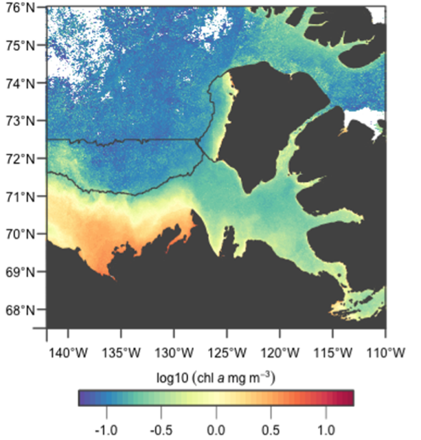
Satellite-measured Chlorophyll-a concentration in the Canadian Beaufort Sea (1998-2020)
This record contains satellite-sensed chlorophyll-a concentration images of the Canadian Beaufort Sea at 1.1 km resolution. The dataset consists of 276 images, aggregated into two-week composites by calculating the mean value at each pixel, comprising years 1998 through 2020.
The dataset spans two ocean colour sensors, MODIS-Aqua and SeaWiFS. The Arctic Ocean Empirical algorithm was used to calculate chlorophyll-a concentration, after images were corrected for atmospheric effects using the NIR-SWIR switching algorithm, and Remote Sensing Reflectance (Rrs) were produced. A linear transform in log-10 space was applied to the chlorophyll-a concentration measured by SeaWiFS to improve its correlation with chlorophyll-a concentration measured by MODIS-Aqua.
The months of October through February were excluded from these datasets as the sun angle in winter is too low (e.g., polar night) for reliable data to be acquired, and the region is mostly covered in sea ice.
For further details, see Galley et al., 2022.
Simple
- Date ( RI_366 )
- 1998-04-30
- Date ( RI_367 )
- 2022-02-11
- Purpose
- This record contains the data processed and summarized in the technical report "Remotely-sensed sea-ice and chlorophyll a variability in the Beaufort Sea from 1998 to 2020" (Galley et al., 2022; ISSN 1488-5417; https://waves-vagues.dfo-mpo.gc.ca/Library/41030035.pdf).
- Status
- onGoing; enContinue RI_596
- Maintenance and update frequency
- asNeeded; auBesoin RI_540
- DFO Areas Zones du MPO ( RI_525 )
-
- Arctic Ocean
- Beaufort Sea
- Government of Canada Core Subject Thesaurus Thésaurus des sujets de base du gouvernement du Canada ( RI_528 )
-
- Oceans
- Classification
- unclassified; nonClassifié RI_484
- Use limitation
- Open Government Licence - Canada (http://open.canada.ca/en/open-government-licence-canada)
- Access constraints
- license; licence RI_606
- Use constraints
- license; licence RI_606
- Spatial representation type
- grid; grille RI_636
- Metadata language
- eng; CAN
- Character set
- utf8; utf8 RI_458
- Topic category
-
- Environment
- Oceans
- Biota
- Climatology, meteorology, atmosphere
- Begin date
- 1998-04-30
- End date
- 2020-10-01
- Description
- Beaufort Sea Region
))
- Supplemental Information
-
PARAMETERS COLLECTED:
Chlorophyll-a concentration
- Reference system identifier
- http://www.epsg-registry.org / EPSG:4326
- Distribution format
-
-
GeoTIF
(
n/a
)
-
GeoTIF
(
n/a
)
- OnLine resource
-
Remotely-sensed sea-ice and chlorophyll a variability in the Beaufort Sea from 1998 to 2020
(
HTTPS
)
Supporting Document;PDF;eng
- OnLine resource
-
Data Dictionary
(
HTTPS
)
Supporting Document;PDF;eng,fra
- OnLine resource
-
File descriptions
(
HTTPS
)
Supporting Document;CSV;eng,fra
- OnLine resource
-
Satellite-measured Chlorophyll-a concentration in the Canadian Beaufort Sea (1998-2020)
(
HTTPS
)
Dataset;GeoTIF;eng,fra
- OnLine resource
-
Satellite-measured Chlorophyll-a concentration in the Canadian Beaufort Sea (1998-2020)
(
ESRI REST: Map Server
)
Web Service;ESRI REST;fra
- OnLine resource
-
Satellite-measured Chlorophyll-a concentration in the Canadian Beaufort Sea (1998-2020)
(
ESRI REST: Map Server
)
Web Service;ESRI REST;eng
- File identifier
- ee27e86f-7b18-4e3f-8444-0c5efb6110a4 XML
- Metadata language
- eng; CAN
- Character set
- utf8; utf8 RI_458
- Hierarchy level
- dataset; jeuDonnées RI_622
- Date stamp
- 2025-02-06T16:22:07.563Z
- Metadata standard name
- North American Profile of ISO 19115:2003 - Geographic information - Metadata
- Metadata standard version
- CAN/CGSB-171.100-2009
Overviews
Spatial extent
Provided by
