 Arctic SDI catalogue
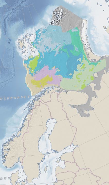
Biotopes of the Barents Sea
Biotopes are unique combinations of species and their environment. This dataset shows a predicted distribution of marine biotopes in the Barents Sea, based on modeling of species composition, seabed sediments, and oceanographic data.
Simple
- Date ( Creation )
- 2025-02-21
- Date ( Publication )
- 2015-09-20
- Date ( Revision )
- 2025-02-24
- Unique resource identifier
- biotoper_barentshavet
- Purpose
- The Barents Sea hosts a wide variety of marine life, including unique species and ecosystems. The Barents Sea is a key area for scientific research due to its unique Arctic conditions. The dataset was developed to show what are the characteristic biotopes of the Barents Sea and to delineate the geographical distribution of these distinct biotopes.
- Status
- Completed
- Maintenance and update frequency
- Not planned
- Keywords ( Place )
-
- Barents Sea
- Keywords ( Theme )
-
- marine
- biotope
- prediction
- modelled
- seabed
- Specific usage
-
The species that live on the seabed are not evenly distributed, but occur in patches linked to different environments and bottom types. This distribution is important to undrestand in order to manage the seabed in the most sustainable way possible. The maps can be used when designing management plans, scientific research, conservation and for making recommendations related to the use of the marine areas.
The level of detail of the dataset indicates use within the map scale: 1:3 000 000 - 1:10 000 000.
- Use limitation
- Detaljnivået på datasettet tilsier bruk innenfor kartmålestokken: 1:3 000 000 - 1:10 000 000.
- Access constraints
- Other restrictions
- Other constraints
- Åpne data
- Use constraints
- Other restrictions
- Other constraints
- Norsk lisens for offentlige data (NLOD)
- Spatial representation type
- Grid
- Distance
- 4000 m
- Metadata language
- Norskno
- Topic category
-
- Geoscientific information
N
S
E
W
))
- Supplemental Information
- The biotope map is a full coverage raster dataset at 4000m resolution.
- Unique resource identifier
- EPSG:25836
- Distribution format
-
-
GeoTIFF
()
Distributor
- Units of distribution
- Region, County
- OnLine resource
- https://nedlasting.ngu.no/api/capabilities/ ( GEONORGE:DOWNLOAD )
-
PNG
()
Distributor
- Units of distribution
- Region
- OnLine resource
- https://geo.ngu.no/mapserver/NOR_RUS_BarentsSeaWMS/?request=getcapabilities&service=wms&version=1.3.0 ( OGC:WMS )
-
GeoTIFF
()
Distributor
- OnLine resource
- https://nedlasting.ngu.no/api/atom/efd21e7a-2aaa-4d43-87e5-41f84483aa86 ( W3C:AtomFeed )
-
GeoTIFF
()
- Units of distribution
- regional inndeling, fylkesvis
- OnLine resource
- https://nedlasting.ngu.no/api/capabilities/ ( GEONORGE:DOWNLOAD )
- Hierarchy level
- Dataset
Completeness omission
- Name of measure
- Prosentvis dekning i forhold til datasettets utstrekning
- Measure description
- Datasettets faktiske kartlagte areal i forhold til datasettets spesifiserte utstrekning
Quantitative result
- Value
- 100
Completeness omission
- Name of measure
- Prosentvis oppfyllelse av FAIR-prinsipper
- Measure description
- Angir fullstendighet i forhold til krav fra FAIR-prinsippene (The FAIR Guiding Principles for scientific data management and stewardship)
Quantitative result
- Value
- 87
- Statement
- Each biological sampling station across the Barents Sea study area was assigned to a biotope class based on species composition as identified from trawl samples from the joint Norwegian-Russian Ecosystem Survey made annually by the Institute of Marine Research (IMR, Norway) and the Institute of Marine Fisheries and Oceanography (PINRO, Murmansk, Russia). The relationship of these biotope classes to the physical environment was analysed and selected full coverage physical data were used to create a model and to predict the distribution of biotopes across the entire study area. Biotope classes, defined from species composition, have been published (Jørgensen et al., 2015), and a subset of these biotope classes was used for modelling and prediction of the biotope map by the Geological Survey of Norway, Trondheim. The oceanography data are from a 4 km resolution ROMS model (Lien et al., 2013). The grain-size data are from NGU-SEVMORGEO compilation (Lepland et al., 2014) and bathymetry data are from IBCAO v. 3 provided by the Norwegian Hydrographic Service. The datasettet was modelled at NGU by using ESRI ArcGIS tools.
- File identifier
- efd21e7a-2aaa-4d43-87e5-41f84483aa86 XML
- Metadata language
- Norskno
- Hierarchy level
- Dataset
- Date stamp
- 2026-06-14
- Metadata standard name
- ISO19115
- Metadata standard version
- 2003
Overviews

original

miniatyrbilde

medium
dekningsoversikt
Spatial extent
N
S
E
W
Provided by

Associated resources
Not available