 Arctic SDI catalogue
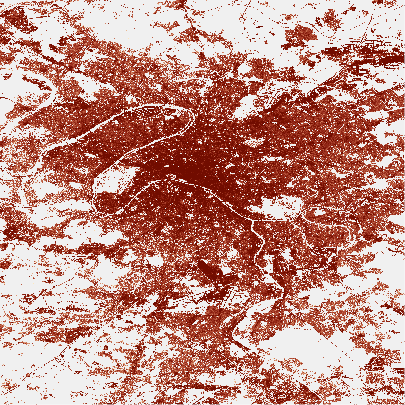
Imperviousness Density 2024 (raster 10 m), Europe, 3-yearly, May 2026
The Imperviousness Density (IMD) 2024 layer is part of the High Resolution Layer (HRL) Imperviousness and contains the approximate density of artificial sealing per pixel (range: 0-100%) for the reference year 2024 as derived from Sentinel-2 image time series. The production of the HRL Imperviousness is coordinated by EEA in the frame of Copernicus, the Earth observation component of the European Union’s Space programme.
The product is a raster dataset with 10-meter grid spacing (spatial resolution) that covers the 38 Eionet member and cooperating countries as well as the United Kingdom (i.e. EEA38+UK). It is distributed as 100 x 100 km tiles that are fully conformant with the EEA reference grid.
Simple
- Date ( Creation )
- 2026-04-21
- Date ( Publication )
- 2026-04-22
- Edition
- 01.00
- Identifier
- copernicus_r_3035_10_m_imd-2024_p_2024_v01_r01
- Identifier
- DAT-14-en
- Unique resource identifier
- 10.2909/f0bcb6f0-d775-4218-bec1-13adea01ff8f
- Codespace
- doi.org
Point of contact
- Maintenance and update frequency
- Continual
- GEMET - INSPIRE themes, version 1.0 ( Theme )
- Keywords
-
- Keywords
-
- GEMET ( Theme )
- Spatial scope ( Theme )
- EEA topics ( Theme )
- Access constraints
- Other restrictions
- Other constraints
- no limitations to public access
- Use constraints
- Other restrictions
- Other constraints
-
The Copernicus component is governed by Regulation (EU) No 2021/696 of the European Parliament and of the Council of 28 April 2021 establishing the Union Space Programme and the European Union Agency for the Space Programme and repealing Regulations (EU) No 912/2010, (EU) No 1285/2013 and (EU) No 377/2014 and Decision No 541/2014/EU. Within the Copernicus component, a portfolio of land monitoring activities has been delegated by the European Union to the European Environment Agency (EEA) and the DG Joint Research Centre of the European Commission.
The Copernicus land monitoring products and services are made available on a principle of full, open and free access, as established by the Commission Delegated Regulation (EU) No 1159/2013 of 12 July 2013.
Free, full and open access to the products and services of the Copernicus Land Monitoring Service is made on the conditions that:
1. When distributing or communicating Copernicus Land Monitoring Service products and services (data, software scripts, web services, user and methodological documentation and similar) to the public, users shall inform the public of the source of these products and services.
2. Where the Copernicus Land Monitoring Service products and services have been adapted or modified by the user, the user shall clearly state this.
3. Users shall make sure not to convey the impression to the public that the user's activities are officially endorsed by the European Union.
- Spatial representation type
- grid Grid
- Distance
- 10 m
- Metadata language
- en
- Character set
- utf8 UTF8
- Topic category
-
- Environment
- Imagery base maps earth cover
- Begin date
- 2024-01-01
- End date
- 2024-12-31
))
- Supplemental Information
-
Pixel codes:
0: All non-impervious areas
1-100: 1-100% Imperviousness Density
255: Outside area
- Unique resource identifier
- EPSG:3035
- Unique resource identifier
- EPSG:32740
- Unique resource identifier
- EPSG:32738
- Unique resource identifier
- EPSG:32620
- Unique resource identifier
- EPSG:32622
- Distribution format
-
-
GeoTIFF
(
1.0
)
-
GeoTIFF
(
1.0
)
- OnLine resource
-
WEkEO Portal
(
WWW:URL
)
Download (requires authentication)
- OnLine resource
- Product Information & Technical Documentation ( WWW:LINK-1.0-http--link )
- OnLine resource
-
HRL_NVLCC_IMD_2024_10m
(
OGC:WMS
)
CLMS_NVLCC_IMD_S2024_R10m
OnLine resource
- OnLine resource
- Digital Object Identifier (DOI) ( DOI )
- Hierarchy level
- Dataset
Conformance result
- Date ( Publication )
- 2010-12-08
- Explanation
- See the referenced specification
- Statement
-
Input data:
Copernicus Sentinel-2 imagery (L2A) acquired from January to December for the reference year 2024.
Pre-processing:
A data reduction algorithm was applied on of the Sentinel-2 time-series to obtain a set of band quantiles. Additionally, a combination of polynomial and harmonic functions were fitted to the time-series of Normalized Difference Vegetation Index (NDVI) to derive harmonic coefficients.
Training and auxiliary data:
Sentinel-2 quantiles 2021/2024,HRL Imperviousness 2021 and CLCplus Backbone 2021/2023, building footprints from different sources (Open Street Maps, Google Open Buildings, Microsoft Building Footprints) were used for model training.
Classification and prediction:
A modified deep convolutional neural network (CNN) called U-Net was trained. The trained model was applied to the Sentinel-2 harmonics and quantiles input to predict raw Imperviousness Densities for the reference year 2024. From these predictions, only high probability predictions (> 70%) were extracted and combined with the sealed areas (class 1) of the CLCplus Backbone 2023 layer to create a binary mask of the impervious surfaces for reference year 2024.
Post-processing:
Steps applied comprise: 1) Calibration using data from different sources (IMD 2021, IBU 2021, NDVI Sentinel 2 harmonics 2021/2024 and CLCplus Backbone 2023) and 2) re-calculation and refinement of the final Imperviousness Density values for the valid impervious surface mask (class 1).
Changes to previous release (2021):
-Interannual rule-based calibration refinement.
-Sentinel 2 input data from Collection 1 (processing baseline => 5.00).
- File identifier
- f0bcb6f0-d775-4218-bec1-13adea01ff8f XML
- Metadata language
- en
- Character set
- UTF8
- Hierarchy level
- Dataset
- Date stamp
- 2026-06-09T08:57:40.731912Z
- Metadata standard name
- ISO 19115/19139
- Metadata standard version
- 1.0
Overviews
Spatial extent
Provided by
