 Arctic SDI catalogue
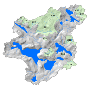
Turkey Lakes Watershed Study
The Turkey Lakes Watershed Study (TLWS) was established in 1979 and is one of the longest running ecosystem studies in Canada. It is 10.5 km2 and is located approximately 60 km north of Sault Ste. Marie, Ontario at the northern margin of the Great Lakes – St. Lawrence forest region. Researchers from Natural Resources Canada, Environment Canada and Fisheries and Oceans Canada established the research watershed to evaluate the impacts of acid rain on terrestrial and aquatic ecosystems. Since its inception, the study has taken a multi-disciplinary approach to investigating the processes that govern ecosystem responses to natural and anthropogenic perturbations.
The goal of the TLWS is to obtain a whole-ecosystem analysis of the biogeochemical processes operating at the site. This permits system models to be developed and validated. The holistic approach that has been adopted from the outset allows research to evolve and expand from its original acidification focus to include evaluations of other environmental issues.
Partnerships and collaboration are part of the founding principles behind the TLWS to improve our ability to measure, model and predict effects of human activity on ecosystem function. Over time, research and monitoring have expanded to explore the effects of forest harvesting, climate change, aquatic habitat manipulations and toxic contaminants. Advancements of our scientific knowledge of forest ecosystems and a baseline of long-term environmental data enables study results to inform Canadian governments on environmental policy and forest management legislation.
Hydrological, meteorological, and vegetation data collected by scientists at the Great Lakes Forestry Centre is included in this directory. Experimental sites and scientific investigations in the TLW are summarized in the compendium document. Visit our website at:
Simple
- Date ( RI_367 )
- 2020-01-27
- Date ( RI_366 )
- 1979
- Status
- onGoing; enContinue RI_596
- Maintenance and update frequency
- asNeeded; auBesoin RI_540
- Keywords ( RI_525 )
-
- Turkey Lakes Watershed
- Government of Canada Core Subject Thesaurus Thésaurus des sujets de base du gouvernement du Canada ( RI_528 )
-
- Air pollution
- Water
- Acid rain
- Wetlands
- Watersheds
- Aquatic ecosystems
- Biological diversity
- Boreal ecosystems
- Chemistry
- Climate change
- Environmental adaptation
- Environmental sciences
- Environment
- Ecology
- Environmental indicators
- Environmental management
- Natural resources
- Scientific information
- Soil
- Resources management
- Inland waters
- Hydrology
- Scientific research
- Streams
- Trees
- Terrestrial ecosystems
- Trends
- Water quality
- Ecosystems
- Fresh water
- Forestry
- Forests
- Environmental quality
- Model forests
- Forest management
- Lakes
- Research
- Use limitation
- Open Government Licence - Canada (http://open.canada.ca/en/open-government-licence-canada)
- Access constraints
- license; licence RI_606
- Use constraints
- license; licence RI_606
- Spatial representation type
- textTable; texteTable RI_637
- Metadata language
- eng; CAN
- Topic category
-
- Environment
- Begin date
- 1979
- End date
- 2020
))
- Reference system identifier
- http://www.epsg-registry.org / EPSG:3978 /
- Distribution format
-
-
HTML
(
unknown
)
-
PDF
(
unknown
)
-
HTML
(
unknown
)
- OnLine resource
-
Turkey Lakes Watershed
(
ESRI REST: Map Server
)
Web Service;ESRI REST;eng
- OnLine resource
-
A Compendium of Experimental Sites and Scientific Investigations in the Turkey Lakes Watershed
(
HTTPS
)
Supporting Document;PDF;eng
- OnLine resource
-
A Compendium of Experimental Sites and Scientific Investigations in the Turkey Lakes Watershed _French Version
(
HTTPS
)
Supporting Document;PDF;fra
- OnLine resource
-
Turkey Lakes Watershed
(
ESRI REST: Map Server
)
Web Service;ESRI REST;fra
- OnLine resource
-
Turkey Lakes Watershed
(
OGC:WMS
)
Web Service;WMS;eng
- OnLine resource
-
Turkey Lakes Watershed
(
OGC:WMS
)
Web Service;WMS;fra
- File identifier
- f2ac0ae9-dd2f-4a70-b059-f8a49d9f5982 XML
- Metadata language
- eng; CAN
- Character set
- utf8; utf8 RI_458
- Hierarchy level
- series; série RI_623
- Date stamp
- 2021-11-18T20:39:42
- Metadata standard name
- North American Profile of ISO 19115:2003 - Geographic information - Metadata
- Metadata standard version
- CAN/CGSB-171.100-2009
Overviews
Spatial extent
Provided by
