 Arctic SDI catalogue
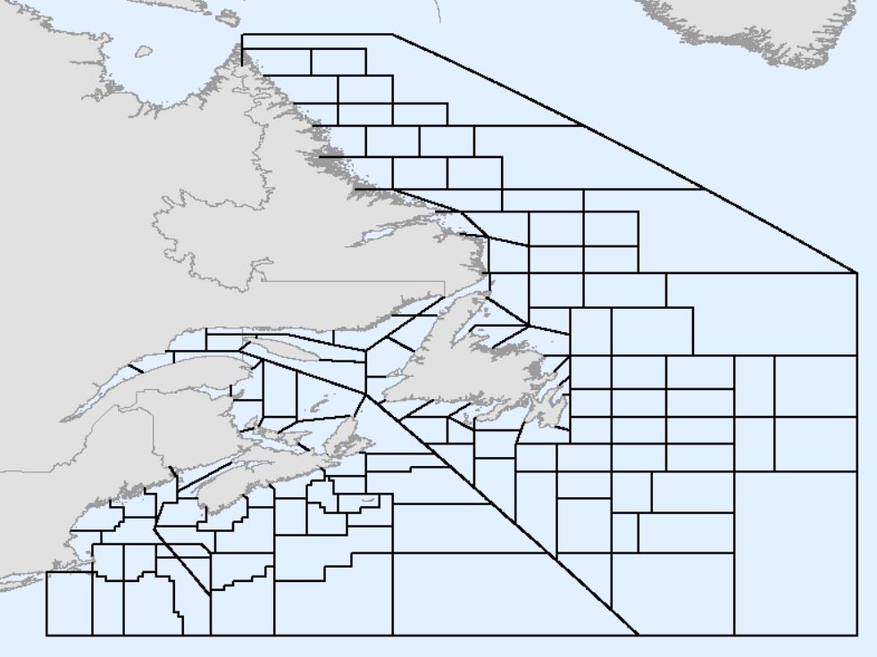
DFO Unit Areas, Atlantic Canada
Fisheries and Oceans Canada (DFO) statistical unit areas (also referred to as unit areas) are smaller portions of the Northwest Atlantic Fisheries Organization (NAFO) Subareas, Divisions, and Subdivisions defined in the Convention on Cooperation in the Northwest Atlantic Fisheries (2020). The spatial representation of boundaries defined by NAFO has recently been updated to address inconsistencies and errors in earlier versions, which is available here: https://open.canada.ca/data/dataset/59af1c96-fc8f-4fa0-b398-d65e953eadaa#comment-41855. Unit areas are used by DFO for a variety of purposes including, but not limited to stock assessments, privacy screening of fisheries maps, and statistical analyses.
Unit areas were originally defined throughout the 1940s and 1950s. Subsequently, several revisions and alternate versions were created by DFO in various regions leading to inconsistencies in spatial extent and naming conventions. These changes have not been formally documented. The datasets often have topological errors such as gaps and overlaps, especially along diagonals and coastlines. In addition, inconsistencies have arisen from conflicting interpretations of the NAFO divisions, where not all land points are defined by coordinates. Therefore, DFO, with input from the Canadian Hydrographic Service (CHS), has created an updated version of the DFO unit areas file to address inconsistencies and errors among previous versions. The recently updated NAFO divisions were used as the basis for an updated DFO unit areas file.
This version of the DFO unit areas must not be used for legal purposes. Legal descriptions of fishing area boundaries can be found in the Atlantic Fisheries Regulations, Maritime Provinces Fishery Regulations, and DFO License Conditions.
Simple
- Date ( RI_367 )
- 2023-04-11
- Date ( RI_366 )
- 2023-03-31
- Status
- completed; complété RI_593
- Maintenance and update frequency
- asNeeded; auBesoin RI_540
- Keywords ( RI_528 )
-
- Unit Areas
- Statistical Unit Areas
- Government of Canada Core Subject Thesaurus Thésaurus des sujets de base du gouvernement du Canada ( RI_528 )
-
- Fisheries
- Fishing area
- Boundary waters
- Statistical analysis
- Fisheries management
- Classification
- unclassified; nonClassifié RI_484
- Use limitation
- Open Government Licence - Canada (http://open.canada.ca/en/open-government-licence-canada)
- Access constraints
- otherRestrictions; autresRestrictions RI_609
- Use constraints
- otherRestrictions; autresRestrictions RI_609
- Other constraints
- This version of the DFO must not be used for legal purposes. Legal descriptions of fishing area boundaries can be found in the Atlantic Fisheries Regulations, Maritime Provinces Fishery Regulations, and DFO License Conditions.
- Spatial representation type
- vector; vecteur RI_635
- Metadata language
- eng; CAN
- Topic category
-
- Boundaries
- Oceans
- Begin date
- 2023-04-11
- End date
- 2026-04-28
))
- Reference system identifier
- https://epsg.io / EPSG:4269 /
- Distribution format
-
-
FGDB/GDB
(
10.8.1
)
-
SHP
(
10.8.1
)
-
FGDB/GDB
(
10.8.1
)
- OnLine resource
-
DFO Unit Areas, Atlantic Canada (Methodology)
(
HTTPS
)
Supporting Document;PDF;eng
- OnLine resource
-
DFO Unit Areas, Atlantic Canada (Methodology)
(
HTTPS
)
Supporting Document;PDF;fra
- OnLine resource
-
DFO Unit Areas, Atlantic Canada (ESRI REST)
(
ESRI REST: Map Service
)
Web Service;ESRI REST;eng
- OnLine resource
-
DFO Unit Areas, Atlantic Canada (ESRI REST)
(
ESRI REST: Map Service
)
Web Service;ESRI REST;fra
- File identifier
- f46313a7-f1b5-4dc7-aa3e-1f009a35b345 XML
- Metadata language
- eng; CAN
- Character set
- utf8; utf8 RI_458
- Hierarchy level
- dataset; jeuDonnées RI_622
- Date stamp
- 2026-05-08T13:26:37.502427Z
- Metadata standard name
- North American Profile of ISO 19115:2003 - Geographic information - Metadata
- Metadata standard version
- CAN/CGSB-171.100-2009
Overviews
Spatial extent
Provided by
