 Arctic SDI catalogue
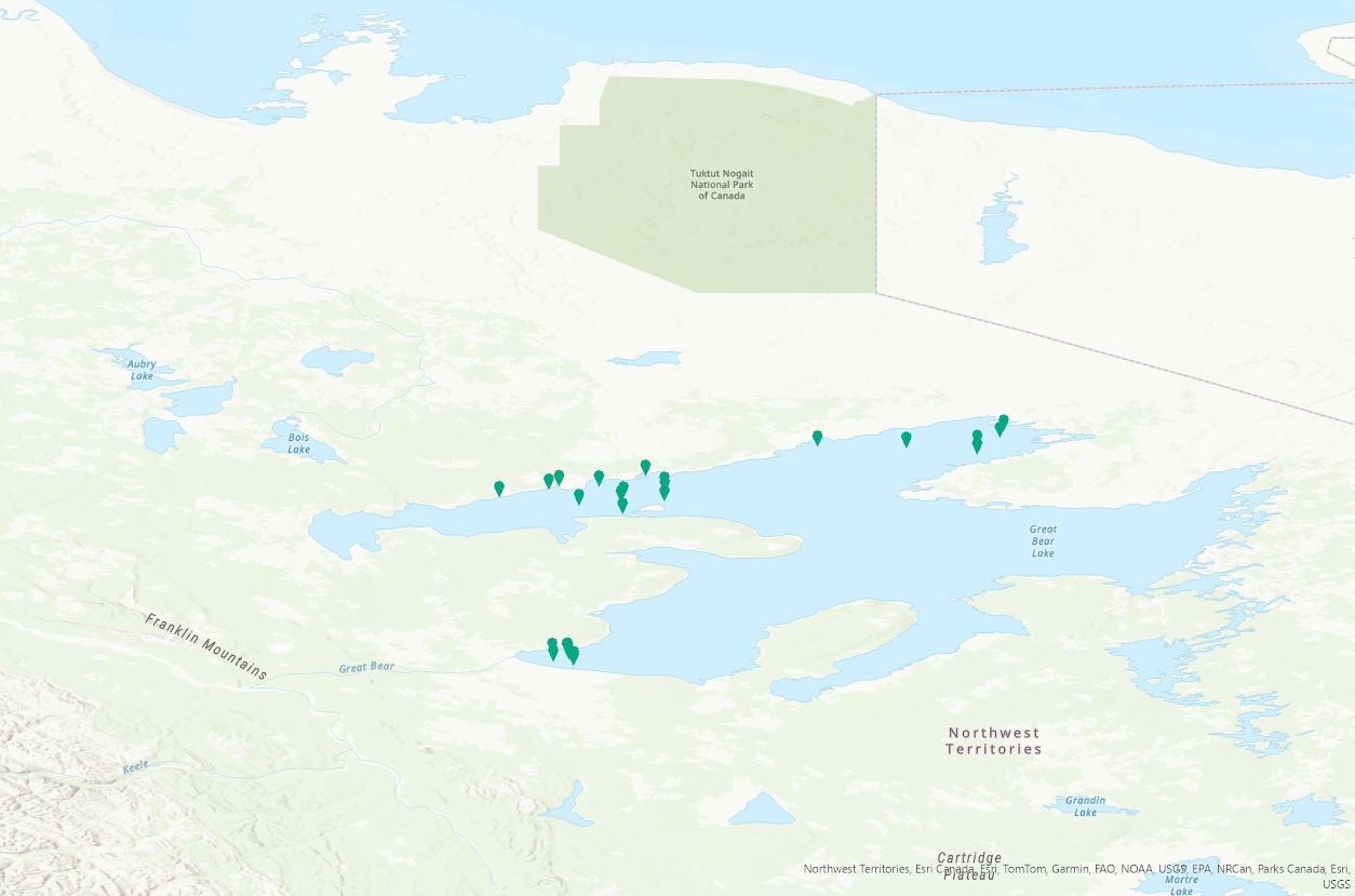
Great Bear Lake (Sahtú) Surface water temperature monitoring: 2021 to 2024
PURPOSE:
This study is part of a two-decade series of research aimed to provide a comprehensive synthesis of the effects of harvest and environmental change on fisheries in Great Bear Lake. The main objectives are to assess demographic traits and the current status of harvested species, with a focus on evaluating sustainable harvest levels of lake trout, a cold-adapted species with a relatively narrow thermal niche. As part of this research, trends in water quality and primary productivity are monitored to evaluate potential effects of change on fisheries.
DESCRIPTION:
Great Bear Lake, one of the largest lakes in North America, contains culturally and recreationally important fish species. Great Bear Lake is located in the sub-Arctic and Arctic Circle. As part of a two-decade series of research aimed to provide a comprehensive synthesis of the effects of harvest and environmental change on fisheries in Great Bear Lake, the main objectives of this study are to assess demographic traits and the current status of harvested species, with a focus on evaluating sustainable harvest levels of lake trout, a cold-adapted species with a relatively narrow thermal niche. As part of this research, trends in water quality and primary productivity are monitored to evaluate potential effects of change on fisheries. From 2021 to 2024, surface water temperature data was collected at depths of 0.1 to 1.0 meters using an RBR Maestro3 through partnered community-led and community/Fisheries and Oceans Canada/university partner collaborative sampling. The project has strong community involvement, including youth through the Guardian Program, to facilitate capacity building and community leadership in the long-term monitoring of Great Bear Lake fisheries and the aquatic ecosystem. This data is an extension of baseline data sets on water quality on the lake. These data will contribute to a better understanding cumulative impacts of climate change on the functioning of large northern lake ecosystems and provide a benchmark for monitoring further change. This data will be important for developing effective strategies for maintaining community-led aquatic monitoring and managing natural resources, particularly fish, which are expected to be increasingly important to communities with declines in other country foods such as caribou.
We acknowledge the data were collected in the Sahtú Settlement Area and are made publicly available with the agreement of the Délı̨nę Renewable Resources Council (Délı̨nę Ɂehdzo Got’ı̨nę (Renewable Resources Council)).
Collaborators include: the Community of Délı̨nę partners (data collection), Délı̨nę Renewable Resource Council, Sahtú Renewable Resource Board, and University of Manitoba. Community of Délı̨nę partners and field workers that participated in data collection include Chris Yukon, Archie Vital, Ted Mackienzo, Daniel Baton, Lloyd Baton, Simon Neyelle, and Stanley Ferdanan.
Funding and logistical support was provided by: Northwest Territories Cumulative Impact Monitoring, Sahtú Renewable Resource Board, the Polar Continental Shelf Program and Fisheries and Oceans Canada.
Simple
- Date ( RI_366 )
- 2021
- Date ( RI_367 )
- 2024-12-03
- Purpose
- This study is part of a two-decade series of research aimed to provide a comprehensive synthesis of the effects of harvest and environmental change on fisheries in Great Bear Lake. The main objectives are to assess demographic traits and the current status of harvested species, with a focus on evaluating sustainable harvest levels of lake trout, a cold-adapted species with a relatively narrow thermal niche. As part of this research, trends in water quality and primary productivity are monitored to evaluate potential effects of change on fisheries.
- Status
- completed; complété RI_593
- Maintenance and update frequency
- notPlanned; nonPlanifié RI_542
- uncontrolled vocabulary; user-specified vocabulaire libre; spécifié par l'utilisateur ( RI_528 )
-
- Freshwaters
- Great Bear Lake (Sahtú)
- Ecosystem monitoring
- RBR Maestro
- Sub-Arctic
- NASA/Global Change Master Directory (GCMD) Science Keywords Version 6.0.0.0.0 NASA/Global Change Master Directory (GCMD) Science Keywords Version 6.0.0.0.0 ( RI_528 )
-
- Aquatic Ecosystems
- Water Quality
- Surface Water
- Government of Canada Core Subject Thesaurus Thésaurus des sujets de base du gouvernement du Canada ( RI_528 )
-
- Arctic
- Temperature
- DFO Areas Zones du MPO ( RI_525 )
-
- Great Bear Lake
- Use limitation
- Open Government Licence - Canada (http://open.canada.ca/en/open-government-licence-canada)
- Access constraints
- license; licence RI_606
- Use constraints
- license; licence RI_606
- Use limitation
- Open Government Licence - Canada (http://open.canada.ca/en/open-government-licence-canada)
- Classification
- unclassified; nonClassifié RI_484
- Spatial representation type
- textTable; texteTable RI_637
- Metadata language
- eng; CAN
- Character set
- utf8; utf8 RI_458
- Topic category
-
- Biota
- Climatology, meteorology, atmosphere
- Environment
- Begin date
- 2021
- End date
- 2024
- Description
- Great Bear Lake
))
- Reference system identifier
- http://www.epsg-registry.org / EPSG:4326
- Distribution format
-
-
CSV
(
n/a
)
-
CSV
(
n/a
)
- OnLine resource
-
Great Bear Lake (Sahtú) Surface water temperature monitoring Datastream
(
HTTPS
)
Web Service;HTML;eng,fra
- OnLine resource
-
Data Dictionary.pdf
(
HTTPS
)
Supporting Document;PDF;eng,fra
- OnLine resource
-
surface_temps_2021-2024.csv
(
HTTPS
)
Dataset;CSV;eng,fra
- OnLine resource
-
Great Bear Lake Sahtu Surface Water Temp Monitoring 2021-2024
(
ESRI REST: Map Service
)
Web Service;ESRI REST;eng
- OnLine resource
-
Great Bear Lake Sahtu Surface Water Temp Monitoring 2021-2024
(
ESRI REST: Map Service
)
Web Service;ESRI REST;fra
- File identifier
- f54da23c-3a17-11ef-90aa-8b219c568296 XML
- Metadata language
- eng; CAN
- Character set
- utf8; utf8 RI_458
- Hierarchy level
- dataset; jeuDonnées RI_622
- Date stamp
- 2025-10-15T14:08:26.725Z
- Metadata standard name
- North American Profile of ISO 19115:2003 - Geographic information - Metadata
- Metadata standard version
- CAN/CGSB-171.100-2009
Overviews
Spatial extent
Provided by
